Home page > Maps > Russia on Maps > Maps of the Petrine Era
A REMARKABLE TRIAD: THE SCIENCE, ART AND EDUCATION

Maps of Peter the Great's Time

Peter I on the background of the Russian Grand Embassy in Amsterdam.
The name of Peter I is associated with great advances made in Russian mapping. When coming to the throne in 1682, the Tsar embarked an essential state reforms, including the development of Russian cartography as a science. Peter I proceeded from the current political, military and economic needs of the country, guided by a strictly defined plan and system. Peter the Great undertook the task of geographically studying and mapping the whole country. Нis decrees were intended to carry out systematic surveys for the needs of the fleet and for compiling up a general map of Russia. Peter I issued orders to establish domestic schools to train professional map-makers, cartographers, geodesists, engravers etc, and to organize map-printing in Russia.

The Petrine era's cartographic material is represented by three types of maps.

  1. Charts of Water Areas and Adjacent Coastal Areas.
  2. Maps of the Newly Acquired Territories.
  3. Plans of Individual Battles (See the section «Maps of the Northern War»).


Charts of Water Areas and Adjacent Coastal Areas

Azov and Black Seas

Mapping of the seas is an important milestone in the history of Russian cartography. The first instrumental surveys in Russia were based exactly on hydrographic studies. They were connected during the Azov campaigns of Peter I:

  • 1696 – survey and description of the Voronezh river from the city of Voronezh to the point of its confluence into the Don and further along the Don to Korotoyak;
  • 1699 – hydrographic and survey work on the Don River;
  • 1699-1700 – оsurvey and description of the southern coast of Crimea during the embassy of E. Ukraintsev in Turkey.

First Russian navigational atlas
The atlas «A Diligent Description of the Don or Tanais River…» was compiled from the materials of these surveys. The atlas later was printed in Amsterdam, the profiles of the Black Sea and the map of the eastern part of the Azov Sea.

First Russian Navigational Atlas.
It was the first Russian navigational atlas to made not from foreign materials, but on the basis of a survey conducted under the leadership of Admiral Cornelius Cruys. Peter I also took part in the work.
K 1-RossE 8/16
Electronic resource

Map of the Eastern Part of Sea of Azov
Sea of Azov The Eastern Part of the Sea [usually known as] Palus Maeotis and now Called the Sea of Azov…(Vostochnaja chast' morja palus meotis i nyne nazyvaetsja azovskoe more…) - [Moscow: Kremlin Armoury], 1701
The map of the eastern part of the Sea of Azov, the Kerch Strait and parts of the Black Sea was compiled from measurements and surveys performed in 1699 with the participation of Peter I.
It is the first printed sea map to be produced from Russian materials.
K 1-Cher 2/11
Electronic resource

Description of the Sea Coasts Starting from the Sea of Azov, even to Constantinople…
Description of the sea coasts starting from the Sea of Azov, even to Constantinople… (Izobrazhenie okazanija morskih beregov nachinajushhajasja ot azovskogo morja, dazhe do Konstantinopolja…) (profiles). − Moscow : [Kremlin Armoury], 1704.
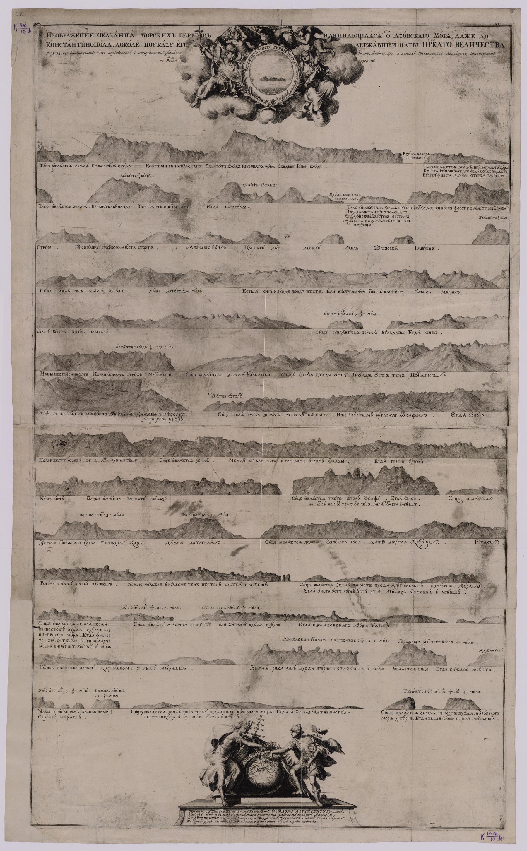
The engraving is produced from a picture made by Christian Ott by order of Peter I in 1700.
Christian Ott was the first captain's mate on the ship of the Ambassador E. Ukraintsev. He surveyed the Bosporus, drew a profile of the coast and compiled a map of the Black Sea in Russian and Dutch in 1700. His handwritten map served as the material for creating a map of the eastern part of the Azov Sea.
K 1-Cher 4/10
Electronic resource


White Sea

View of Arkhangelsk on the map «Tabula Russiae…»

View of Arkhangelsk on the map «Tabula Russiae…»
The only port through which Russia conducted its trade with European partners was located at Arkhangelsk on the White Sea. That is why, mapping of the White Sea was given great attention since the beginning of the 18th.

Electronic resource

Plan of the Dvina River or Arkhangelsk
Plan of the Dvina River or Arkhangelsk. Made by Adriaan Schoonebeeck in 1701 by the order of his Tsar's Majesty. − Moscow : [Kremlin Armoury], 1701.
The map of the mouths of the Northern Dvina River is one of the first dated maps engraved and published by the Kremlin Armoury in Moscow. It is was re-engraved with changes in the cartouches and slight changes in the inscriptions from the edition: J. van Keulen «Nieuwe Lichtende Zee-Fakkel», [1681-1684].
K 1-Sev 2/19
Electronic resource

Map of the Northern Part of the White Sea
Map of the Northern Part of the White Sea (Rozmernaja karta nachinajushhaja ot uskogo prohoda mezhdu Ruskago i Belago morja i ot Tipeny dazhe do kaskarivy takozhde ot Kandenosa dazhe do Katsnusa). By the order of his Tsar's Majesty. Copper-plate engraving by Adriaan Schoonebeeck. − [Moscow : Kremlin Armoury, 1702].
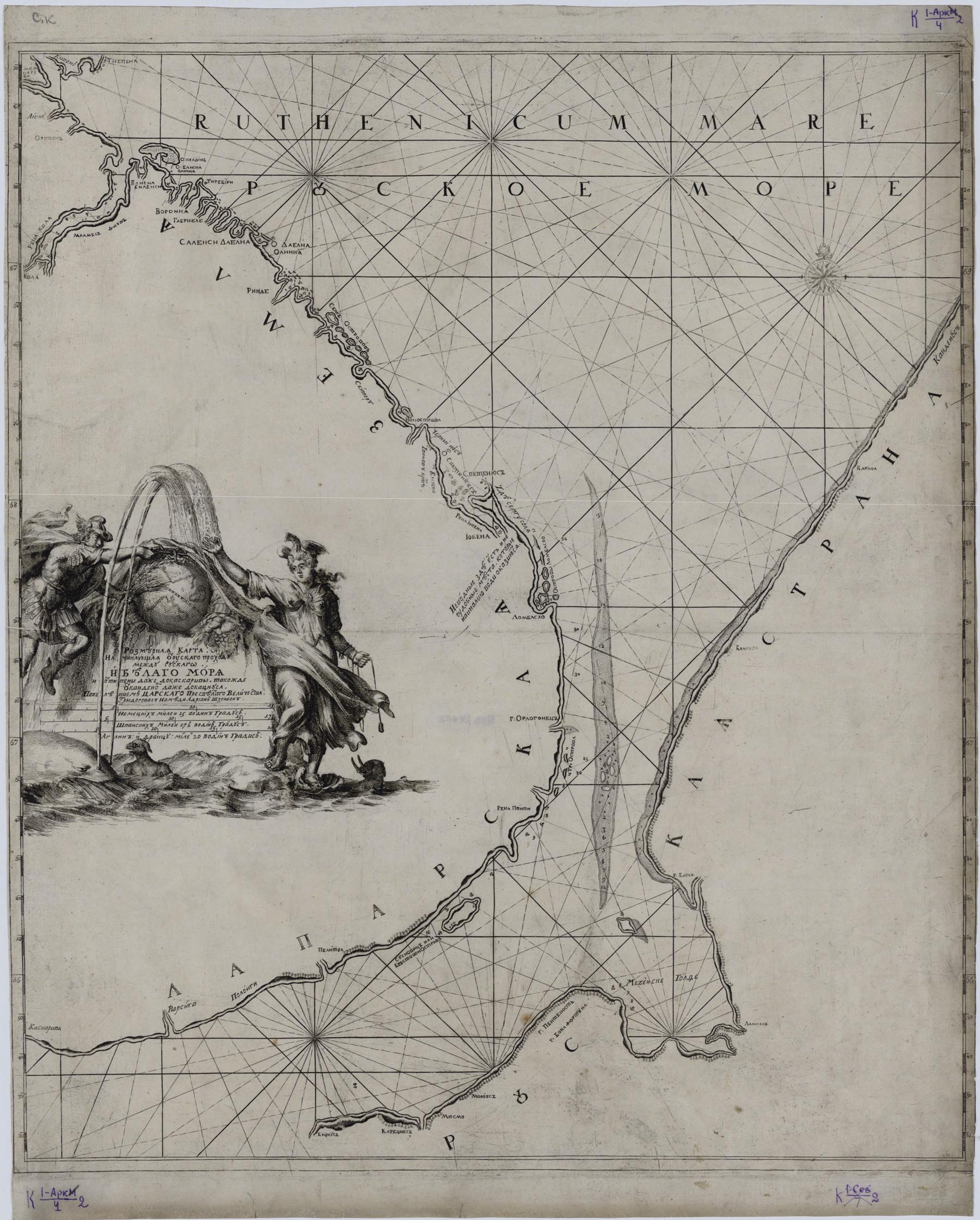
Map of the northern part of the White Sea was re-engraved with changes in the cartouches and slight changes in the inscriptions from the edition: J. van Keulen «Nieuwe Lichtende Zee-Fakkel» [1681-1684]. Some of the place names from the Dutch map were transliterated, for example "Svetenius" instead of "Saint Nose". The map partially overlaps with the map «Map of the White Sea with Adjacent Territories…», somewhat different in scale.
K 1-Ark 2/4
Electronic resource

Map of the White Sea with Adjacent Territories
Map of the White Sea with Adjacent Territories (Rozmernaja karta Belago morja nachinajushhajasja otpelitcy dazhe do Kovady …) − Moscow : Kremlin Armoury, 1703.
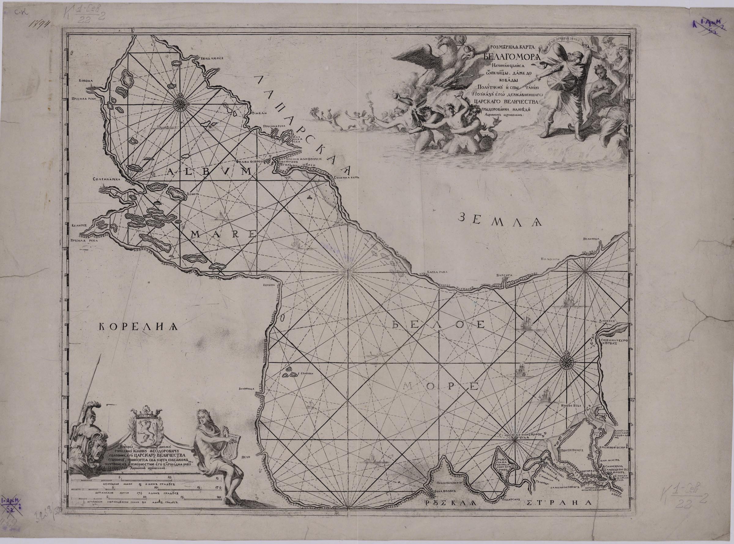
Map of the White Sea with adjacent territories. It is was re-engraved with changes in the cartouches and slight changes in the inscriptions from the edition: J. van Keulen «Nieuwe Lichtende Zee-Fakkel» [1681-1684]. The map partially overlaps with the map «Map of the Northern Part of the White Sea», somewhat different in scale.
K 1-Sev 2/2
Electronic resource


Baltic Sea

At first, Russian maps of the Baltic Sea were compiled from information obtained from Swedish and Dutch sources because the first Russian hydrographic surveys were not large-scale and could not meet the needs of the fleet.

Map of the Eastern Part of the Gulf of Finland
Map of the Eastern Part of the Gulf of Finland (Rozmernaja karta chasti v nachale Baltijskogo morja nachinajushhajasja ot brokloma dazhe do strelny idezhe ost finskij i ot Parny dazhe doshlotburga). By the order of the Tsar's Majesty, Pieter Pickaerdt etched on copper. [Cartouche was engraved by Adriaan Schoonebeeck]. - Shlisselburg: Mobile engraving workshop; Moscow: Kremlin Armoury, 1703].
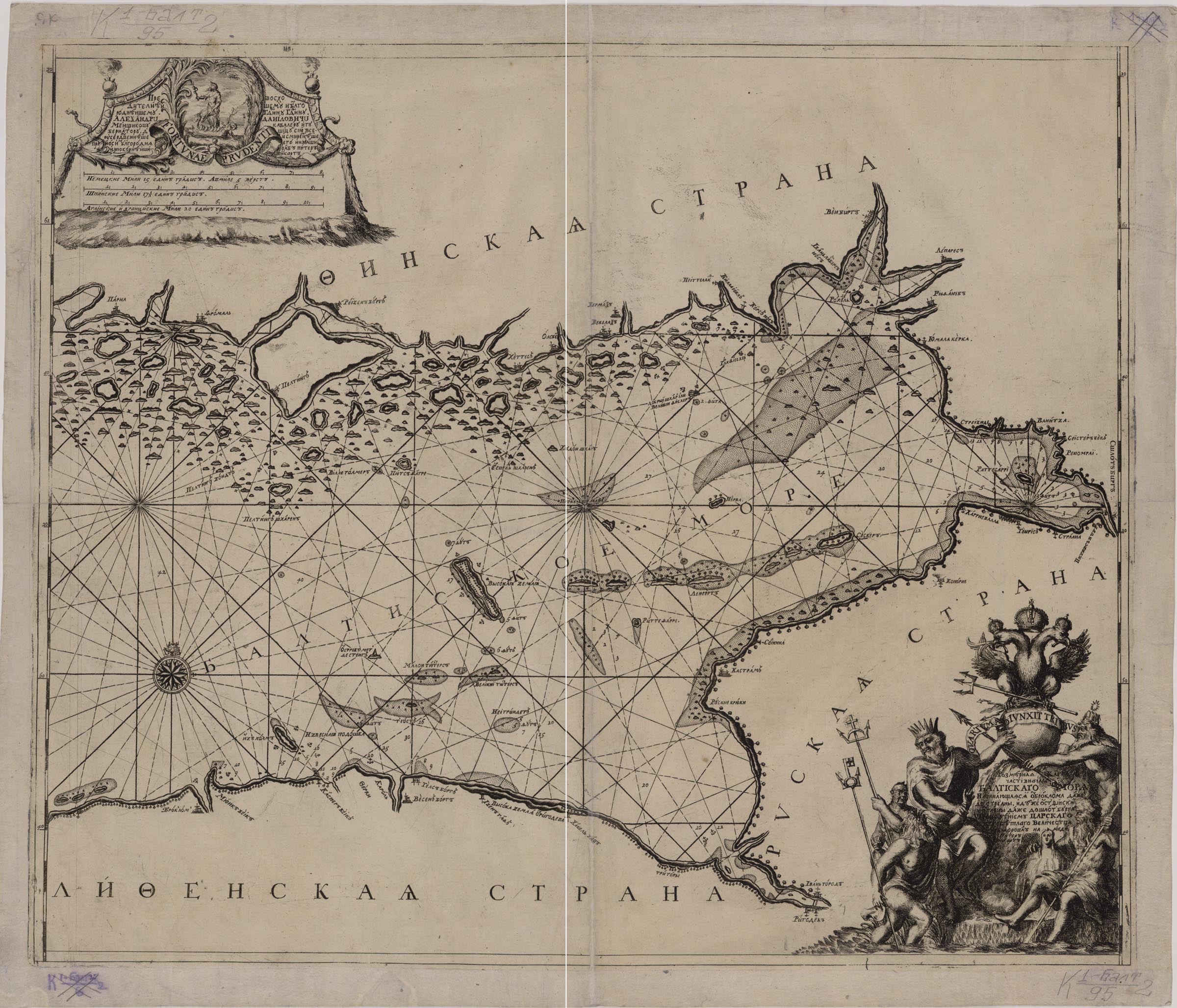
Map of the Eastern Part of the Gulf of Finland is one of the first Russian nautical charts. It was drawn from Swedish sources and was engraved by Pieter Pickaerdt at a mobile engraving workshop that was established by order of Peter I to quickly give display of the military operations during the Northern War. It is one of the first Russian printed maps to depict the newly founded St. Petersburg.
K 1-Balt 2/95
Electronic resource

New Map of the Eastern Part of the Gulf of Finland
New Map of the Part of the Baltic Sea … (Novye rozmernye karta chast' Baltijskoe more) [Drawn by A. Schoonebeeck]. − Shlisselburg : mobile engraving workshop; Moscow : Kremlin Armoury, 1703].
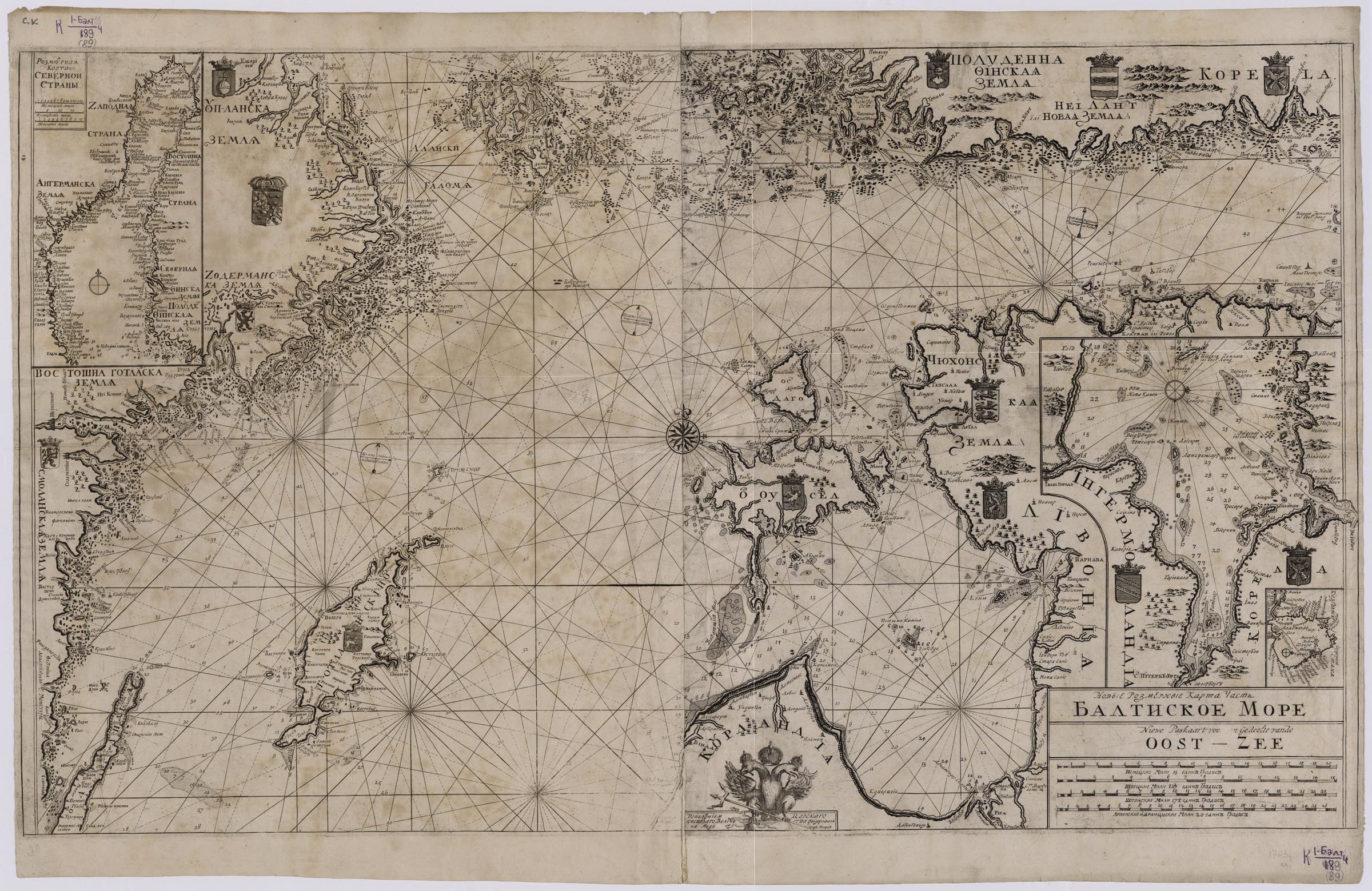
It includes supplementary maps: The Map of thе Northern Country (the Gulf of Bothnia); [Eastern Part of the Gulf of Finland]; [Lake Ladoga]. The New Map of the Part of the Baltic Sea is one of the first Russian nautical charts. It was drawn from Swedish sources and was engraved by Pieter Pickaerdt at a mobile engraving workshop that was established by order of Peter I to quickly give display of the military operations during the Northern War. It is one of the first Russian printed maps to depict the newly founded St. Petersburg.
K 1-Balt 4/89
Electronic resource

Map of the Eastern Part of the Baltic Sea with the Western Part of the Gulf of Finland
Map of the Eastern Part of the Baltic Sea with the Western Part of the Gulf of Finland … (Chast' snachala Vostochnago Morja iz'javljaja Strany, Melei, Kamennyh gor). By the decree of the most powerful Tsar's Majesty, Adrian Shkhonebek etched on cooper, in 1705 in Moscow.− Moscow : [Kremlin Armoury] , 1705.
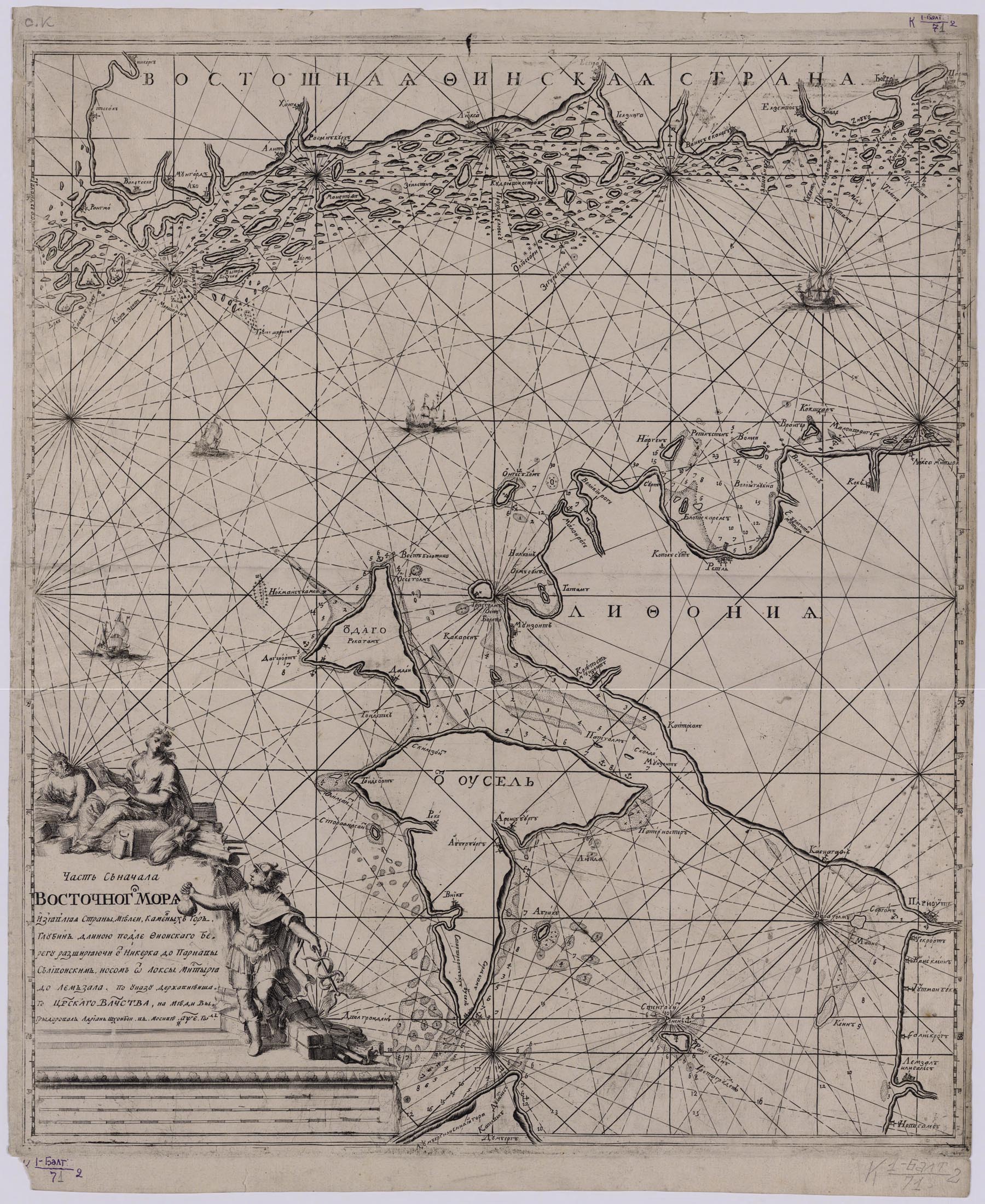
The map of the Eastern Part of the Baltic Sea with the Western Part of the Gulf of Finland includes also the northern part of the Gulf of Riga and the islands of Dago (modern Hiiumaa) and Ezel (morden Saaremaa).
K 1-Balt 2/71
Electronic resource

Map of the Gulf of Finland from Cape of Kleynrog to Cape of Vessenburg
[Map of the Gulf of Finland from Cape of Kleynrog to Cape of Vessenburg. Engraver Pieter Pickaerdt. – Moscow : Kremlin Armoury, 1708].
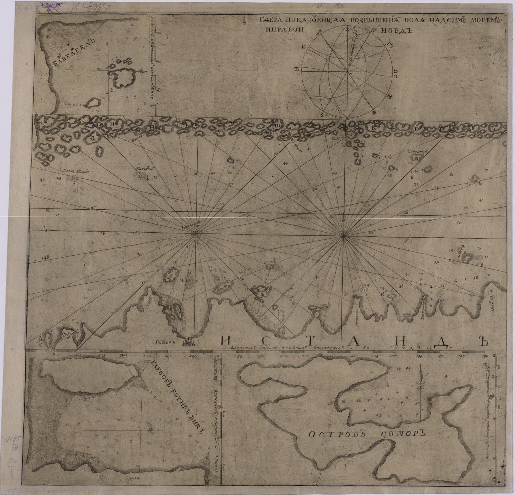
It includes supplementary maps: [Paldiski Bay; Prangli Island; Island of Somor].
K 1-Balt 2/216
Electronic resource

Atlas of the Baltic Sea
In 1714, there was published the first Russian maritime atlas «Atlas of the Baltic Sea (Kniga rozmernaya gradusnykh kart Ost-Zee ili Varyazhskogo morya)». It consists of 15 maps, 12 ones out them were re-engraved from a Swedish atlas of the Baltic Sea, which was compiled using the surveys carried out under the supervision of Swedish admirals Werner von Rosenfelt and Peter Gedda in the 1670s and 1680s. The rest three maps were made from a Russian survey conducted in August 1714 (immediately after the Gangut battle), under the guidance of Lieutenant M. Gris. In 1718 and 1719 the atlas was re-issued with identical content. Seeing the imperfection of published navigational charts, Peter I sent naval officers to many areas of the Baltic to describe them and made measurements. On the basis of these works, several new domestic maps were compiled and then were included in the reissued atlas in 1723.
The cartography department holds an atlas, published in 1719. The title page of the atlas has Pieter Pickaerdt's plate with the view of Petersburg.
K 1-Balt 8/1
Electronic resource


Maps of the Newly Acquired Territories

This type of the Petrine era's maps is represented by a relatively small number of overview maps that do not include significant detail.

Geographical Drawing of Ingermanland
Geographical Drawing of Ingermanland with its Towns, Districts… (Geograficheskii Chertezh nad Izherskoyu Zemlei ssvoimi Gorodami uezdami…)Engraved by Adriaen Schoonebeck. − [Moscow : Kremlin Armoury, 1705].
Electronic resource

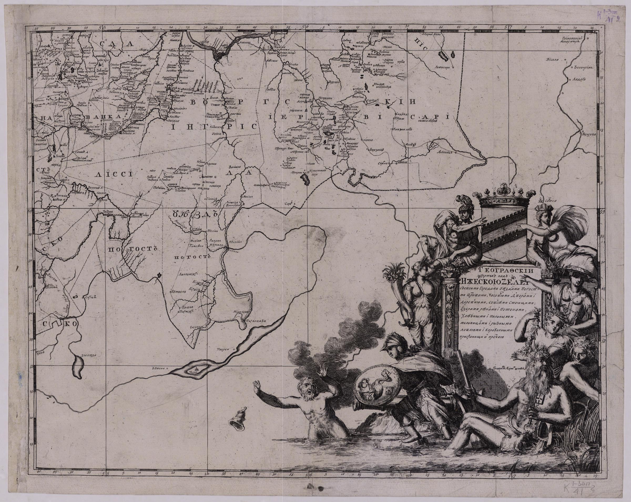
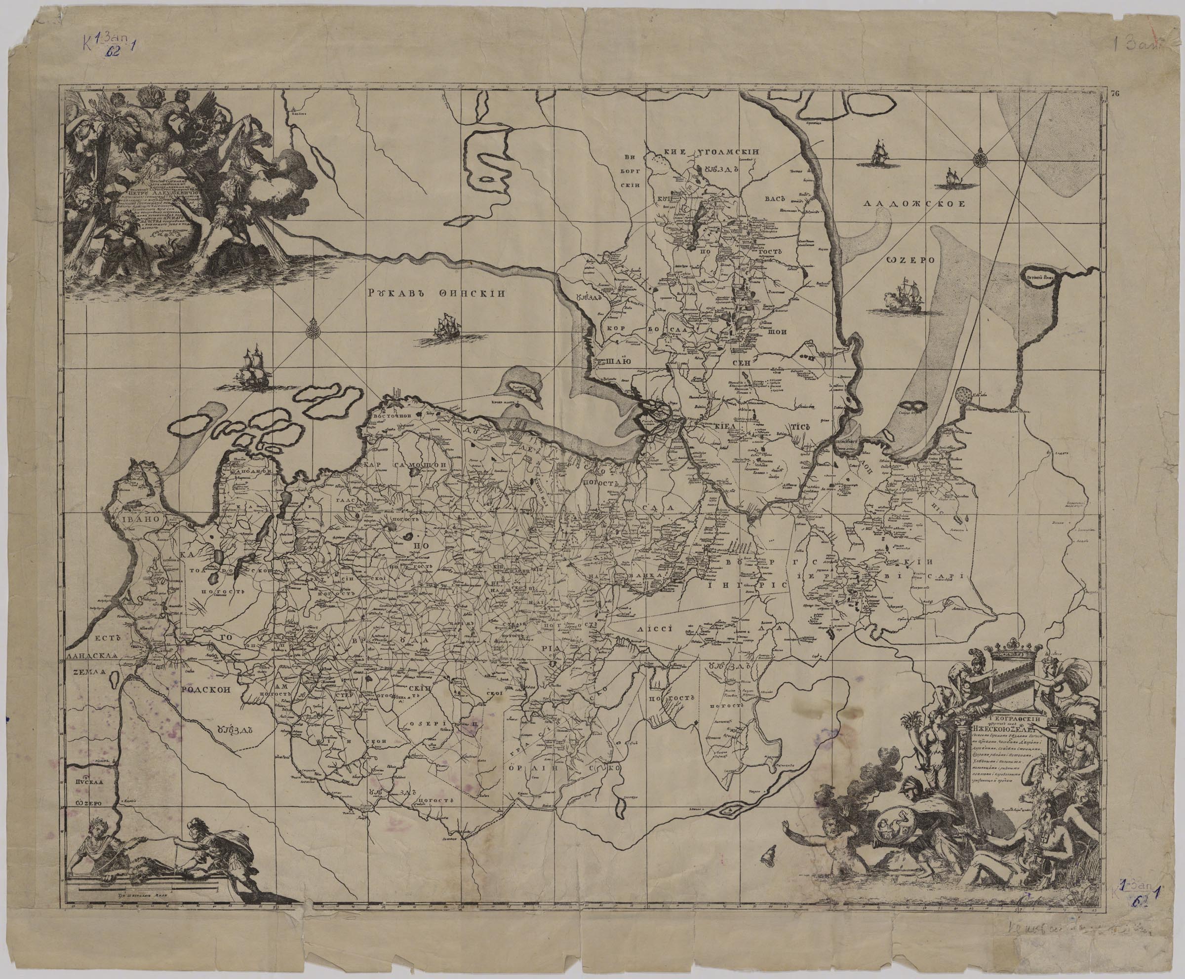
The drawing to the engraving was produced in 1703–1704, immediately after the conquest of Ingermanlandia (Ingria, Izhora land) during the Northern War, in the mobile engraving workshop from Swedish sources with the usage of old place names. Adriaen Schoonebeck began to engrave the map in four sheets in Ganuary 1705. After his death, the work was finished by Pieter Pickaerdt and his Russian pupils. According to some available information, because of the expectation of the final establishment of the border with Sweden, the map was printed only in 1724, after the conclusion of the Nystad Peace.
The Maps Department has an incomplete copy of the original map (2 sheets out of 4) and a reduced reproduction.
K 1-Zap 2/41
K 1-Zap 2/62
Electronic resource

Map of Kingdom of Poland and the Grand Duchy of Lithuania
Map of Kingdom of Poland and the Grand Duchy of Lithuania (Karolevstva Polskago i Velikago Knjazhestva Litovskago Chertezh). By the order of his most powerful Tsar's Majesty, engraved in Moscow by Pieter Pickaerdt. [Cartouche is engraved by A. Schoonebeeck]. − Moscow : [Kremlin Armoury, 1705].
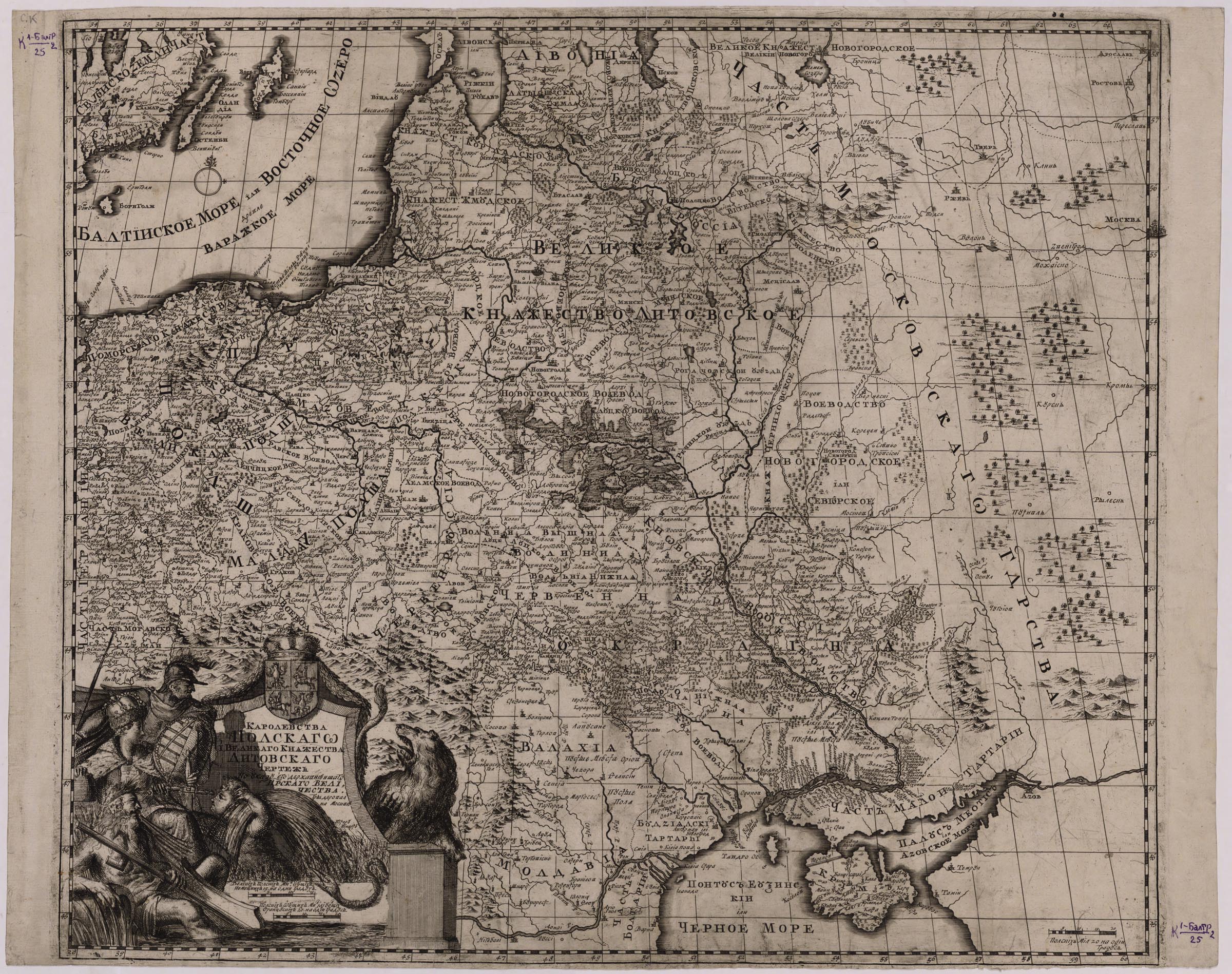
The map covers the territories of Poland, the Grand Duchy of Lithuania, parts of the Moscow Principality and other adjacent states. The map borrowed a drawng of the coast of the Baltic Sea and parts of the charts of water bodies from a map from K. Allard's Atlas (late 17th century). Allard, in his turn, used an image from the map of G. Levasser de Boplan (1650-1651).
K 1-BaltR 2/25
Electronic resource

Map of the Border between Russia and Sweden Established by the Peace Treaty of Nystad of 1721
Map of Russian-Swedish Borders by the Perpetual Peace Terms of 1722 AD (Siya Karta Razgranichenia zemel Vechnogo Mira Mezhdu Rossiiskim i Shvedtskim Gosudarstvy) …. Engraved in Moscow by Pieter Pickaerdt. − [Saint-Petersburg : Saint-Petersburg Printing House, 1724].
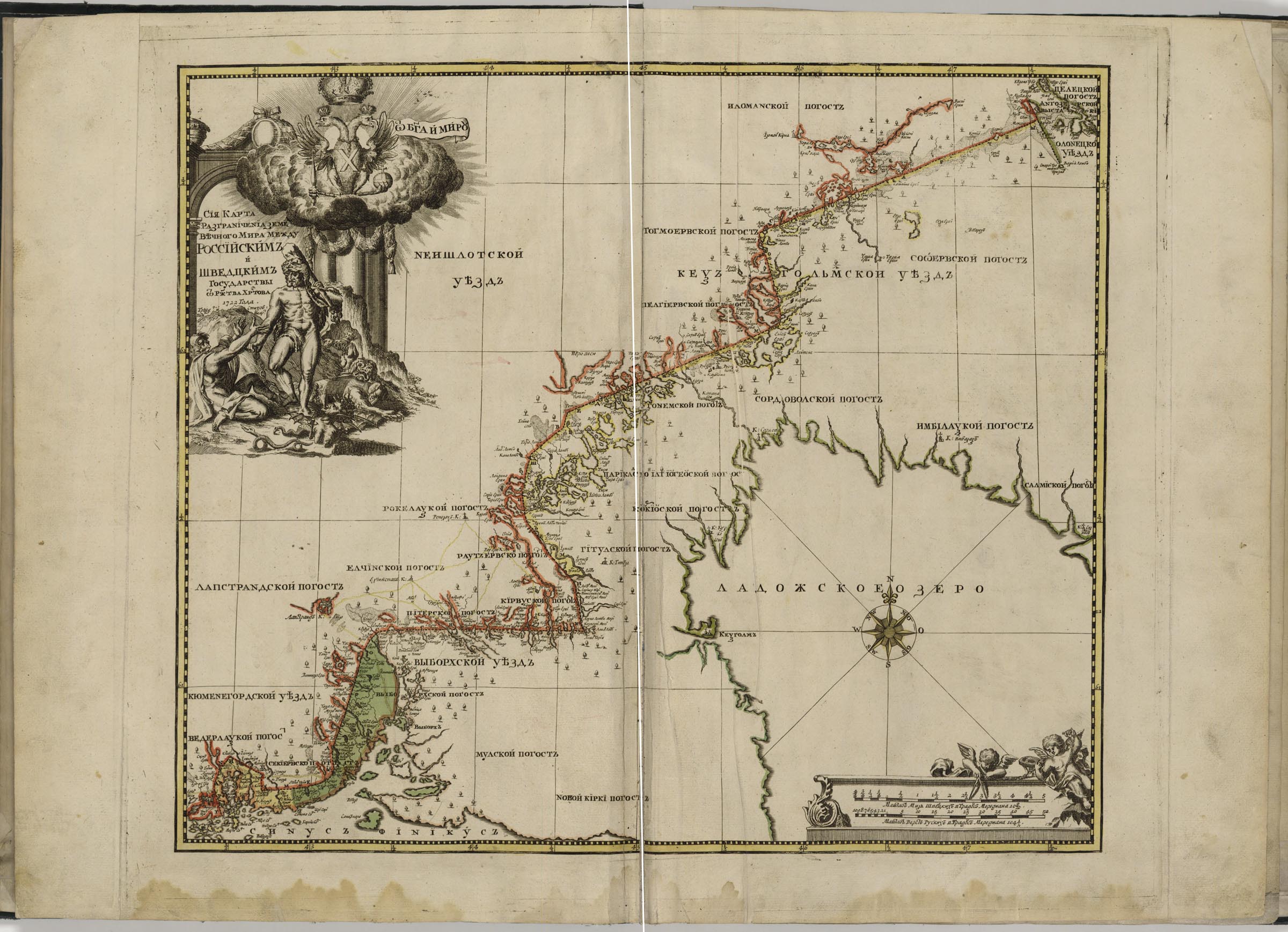
The map of the border between Russia and Sweden established by the Peace Treaty of Nystad of 1721 was produced from the surveys of A. Kleshnin, one of the best geodesists of Peter's time, and A. Zhikhmanov. The first 500 copies of the map were printed in 1724 in Saint-Petersburg at the request of the Senate "for sale to the people". All the surviving copies of the Kirilov Atlas are opened with this map, including an item kept in the Mapps Department of the National Library of Russia.
K 1-Ross 8/4
Electronic resource


<<   Contents   >>

First Russian navigational atlas
Electronic resource
The Eastern Part of the Sea [usually known as] Palus Maeotis and now Called the Sea of Azov…
Electronic resource
Description of the Sea Coasts Starting from the Sea of Azov, even to Constantinople…
Electronic resource
View of Arkhangelsk on the Map «Tabula Russiae…»
Electronic resource
Plan of the Dvina River or Arkhangelsk
Electronic resource
Map of the Northern Part of the White Sea
Electronic resource
Map of the White Sea with Adjacent Territories…
Electronic resource
Map of the Eastern Part of the Gulf of Finland
Electronic resource
New Map of the Eastern Part of the Gulf of Finland…
Electronic resource
Map of the Eastern Part of the Baltic Sea with the Western Part of the Gulf of Finland …
Electronic resource
Map of the Gulf of Finland from Cape of Kleynrog to Cape of Vessenburg
Electronic resource
Atlas of the Baltic Sea
Electronic resource
Geographical Drawing of Ingermanland with its Towns, Districts and their Subdivisions - Pogosty, Churches, Chapels, Homesteads and Villages…
Electronic resource
Geographical Drawing of Ingermanland with its Towns, Districts and their Subdivisions - Pogosty, Churches, Chapels, Homesteads and Villages…
Electronic resource
Map of Kingdom of Poland and the Grand Duchy of Lithuania
Electronic resource
Map of Russian-Swedish Borders by the Perpetual Peace Terms of 1722 AD
Electronic resource