Siberia Mapping
Siberia is a part of Asian territory of Russia. Before 1917 all territories extending from the Ural Mountains to the Pacific were called as Siberia in official documents and scientific literature. Siberian territory was divided into two regions (Siberian Krai and Far Eastern Krai) after establishing Soviet power in Siberia. Since that time the term “Siberia” has two meanings. In one case it means all territory eastwards the Ural Mountains, in another case it means the territory only of western and eastern Siberia without Far East. Siberia (with Far East) occupies 12 765 900 sq.km.
Novgorod dwellers knew northern part of western Siberia as the Yugor land as far back as the 11th century. In the 13th century Yugra was referred among volosts subordinated to Novgorod. In 1558, Moscow government sanctioned the foundation of Stroganovs’ Permic patrimony and this action promoted the development of Siberia by the Russians. The ataman Yermak campaign of 1581 (according to some data of 1579) opened the way to Irtysh valley to the Russians, and the defeat of khan Kuchum in 1598 meant the end of the Siberian khanate.
From the beginning of the 17th century the Russians entered the basin of the middle reaches of the Yenisei. Founded in 1661, Irkutsk stockaded town became the centre of the vast region governed by a voevode which comprised Cis-Baikal and Trans-Baikal lands.
At the beginning of the 18th century Russian possession in the North and East of Siberia reached natural borderlands (with small exceptions): the frontier on the South followed the boundary between forests and steppes, the foothill of Altai and Sayan Mountains, Yablonovy and Stanovoi Ranges.
The development of such vast territory set the grand geographical tasks the solution of which belongs to the Russian science. The most important discoveries in this part of the Earth have been recorded on maps in the period of one hundred years (from the middle of the 17th century, after the campaign of Semen Dezhnev, to the middle of the 18th century, when the Great Siberian-Pacific expedition has finished). The Northern and Eastern boarders of Asian continent were defined and mapped, the correlation between Asian continent and North America was established, the sea routes from Okhotsk to Kamchatka and from Kamchatka to Japan were laid during that century. The astronomical determination of a number of points in Siberia (considering Siberia and Far East) were made, “Baikal Sea” and the most important Siberian rivers were mapped. Apparently, Russian geographical discoveries and investigations of Siberia and Far East in the 17th and 18th centuries made a significant contribution in the world science.
Catalogue
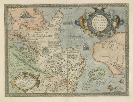
Tartariae sive Magni Chami regni typus / [A. Ortelius. – Antverpen : C. Plantijn, 1570]. // Theatrum orbis terrarum. Л. [98].
К 0-Мир 7/11
See in the Digital Lubrary
The first printed map of Siberia. A map from the atlas "Teatrum orbis terrarum"(Antwerp, 1570) is made up by A.Ortely For a whole century after this map has been published (i.e., before the appearance of the map of Siberia made up by N.Witsen in 1687), west European mapping of Siberia did not reach any appreciable results.
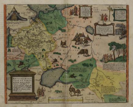
Russiae, Moscoviae et Tartariae descriptio / Auctore Antonio Ienkensono Anglo : edita Londini Anno 1562 et dedicata illustriss. D. Henrico Sydneo Walliae presidi. − [Antverpiae [Antverpen], 1579].
К 0-МоскЕ 2/13
See in the Digital Lubrary
Map of Moskoviae by Antonio Jenkensono is made after the first travel of the author on Russia and Asia and is made on the basis of his personal supervision. In the left top corner of a card there is an image of king Ivan the Terrible. A card from the atlas A.Ortely: "Teatrum orbis terrarum". (Antwerp, 1579).
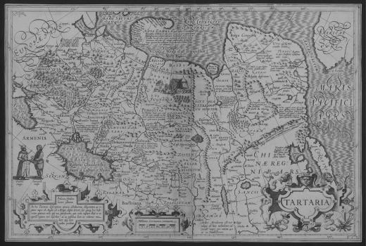
Tartaria. – [Amsterdam : J. Hondius, 1606].
К 0-Сиб 2/1
See in the Digital Lubrary
Map of Siberia is made up by Iodocus Hondius. First it was published in the atlas by Gerhard Mercator complemented by Hondius and published in 1606 under the title Atlas sive cosmographicae meditationes … (Amsterdam). Apparently, it was made up on the basis of Mercator’s World Map of 1569. It also comprised the results of expedition of Willem Barents to Novaya Zemlya (1595-1597). The picture of Siberia does not correspond to reality and partly reflects Ptolemy’s conception. North shore of Asia is washed by “Quiet sea of Russians” (“Niaren More id est Tranguillum …”) with the Island of Tazata and the Cape of Tabin.
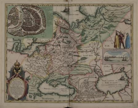
Tabula Russiae ex autographo, quod delineandum curavit Foedor fililus Tzaris Boris desumta, et ad fluvios Dwinam, Zuchanam, aliaque loca, quantum ex tabulis et notiis ad nos delatis fieri potuit, amplificata ……/ dedicata ab Hesselo Gerardo M.DC. XIII. – [Amsterdam], 1613.
К 0-Мир 8/45
See in the Digital Lubrary
Map of Russia is made up by the known Netherlandish geographer and cartographer Hessel Herrits. The map was published in Amsterdam in 1614. It is noted in its cartouche that it is performed according to autograph of czarevitch Fedor Borisovich Godunov, as well as according to maps and information which he could get additionally. Northeastern part of the map is brought to the Pyasina river. The Teneseya (Yenisei) river is shown to the westward from the river Pyasina. The Ob river is shown rising from the Kitaika lake. A part of Novaya Zemlya is shown conventionally.
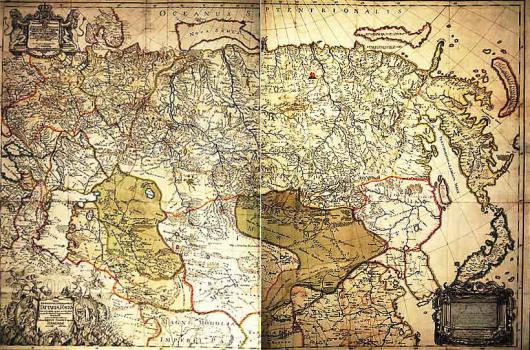
Nova Descriptio Geographica Tartariae Magnae tam orientalis quam occientalis in particularibus et generalibus Territoriis una cum Delineatione totius Imperii Russici imprimis Siberiae accurate ostensa [Philipp-Johann V. Strahlenberg, T.A.Matern, P.F.Frisch, sculpsit. Paris, 1725].
Map of Russia (New geographical description of Tartar). The map is made up by Philipp Strahlenberg (F.Tabbert), captive Swedish officer which lived in Tobolsk from 1711 to 1721. Materials from S.U.Remesov’s atlas and other private maps of Siberia were used to make it up. It was published for the first time in 1725 in Paris, and in 1730 in Stockholm as a supplement to the book by Strahlenberg Das Nord und Ostliche Their von Europa und Asia. There are many uncertainties in this map, and the materials of the First stage of the Second Siberian-Pacific expedition have not been taken into consideration. However, Strahlenberg gives much new information as compared with general maps of Siberia made up by other authors. Though imperfectly he shows Chukchi Peninsula, Kamchatka and gives more exact contours of Caspian Sea detached from Aral Sea etc.
General map of Russian Empire compiled as much diligently as possible by Ivan Kirilov, a chief-secretary of the Senate, in Saint Petersburg in 1734. [G.I.Unverzaht, Engraver. St.Petersburg, 1734]
К 1-Росс 4/50
See in the Digital Lubrary
It is the first review geographical map of Russian Empire. When compiling it, Ivan Kirilov used the maps made up by geodesists-participants of cartographic and geodetic works which were carried out in Russia since 1721 and all achievements of Russian cartography known to him at that time. The materials of the First Expedition of Vitus Bering to Kamchatka were also included in the map. When compiling the map
the disagreement in the maps of provinces and uyezds with each other became apparent which resulted from the insufficient number of reference geodetic points. So the map overstated the extension of the country in longitude for 7-8?. The general map of Russian Empire made up by Kirilov were widely used both in Russia and abroad and served as a source for compiling a number of maps included in atlases made up by Homan, Rober de Vagondi and so on.
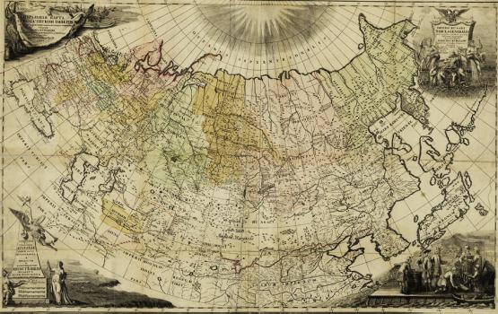
General map of Russian Empire … presenting with possible correctness in a real outlook all the territory of Russian Empire with its provinces. It was begun by the wise intention of Peter the Great … completed at the time of Empress Elizaveta Petrovna … published to nationwide utilization … 1745. [St.Petersburg, Acad.Sci.], 1745.
К 1-Росс 4/52
See in the Digital Lubrary
Map of Russia from the atlas: "Atlas of Russia consisting of 19 special maps presenting All-Russian Empire with borderlands compiled according to geographical rules and new observations …" (St.Petersburg: Acad.Sci., 1745). This atlas is made up and pub-lished by the St.Petersburg Academy of Sciences. The maps are based on the instrumental survey organized over the whole Russia using the materials of the Second expedition of Bering to Kamchatka and the Great North Expedition. The table of conventional signs is used for the first time. This Atlas was the result of twelve-year work of the Academy of Sciences and has been published in Russian, Latin, German, and French. It was made at the high level of possibilities of that time and its publication had the great scientific and political significance for Russia.
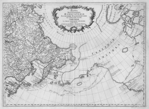
Map of North America with adjacent places made by Russian navigators. Comp. by Ivan Truskot, Titular Counsellor at the Imp.Acad.Sci. [St.Petersburg: Acad.Sci., 1761].
К 1-Тих 2/12
See in the Digital Lubrary
Map of northeastern part of Siberia and northwestern coast of America with the navigation routes of Russian expeditions.
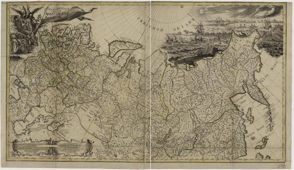
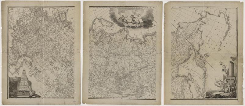
New map of Russian Empire divided into regions ruled by governor-generals. Comp. 1786. [St.Petersburg: Acad.Sci.], 1786.
К 1-Росс 4/57
See in the Digital Lubrary
Map of Russian Empire is made up on the basis of new astronomical observations by I.Truskot together with F.I.Schubert and Ya.Schmidt and published by Geographical Department of the Academy of Sciences. It is the result of the intensive expeditionary and cartographic activity of the Academy of Science in the 18th century.
