Kronstadt. 300 years of its founding
Brief Historical Background
The town of Kronstadt is situated on the small island of Kotlin in the eastern part of the Gulf of Finland, 48 km west of Saint Petersburg.
During the period from 1323 to 1617, the island of Kotlin (Retusari in Finnish, or Rat Island) was considered as a borderland between Russia and Sweden, at that time, it was an area with no people living in. The island was ceded to Sweden in 1617, but Russia regained it along with the Ingrian land from Sweden in the reign of Peter the GreatŴṁ.
The naval base on the island of Kotlin was built by order of Tsar Peter the Great. Construction of the fortness began in 1703, when Prince Menshikov set up a fort on the sandback of the south coast from a model, made by Peter himself. On 7 May 1704 the first fortifications, including two batteries, were constructed. This day is regarded as the date of Kronstadt founding. The fort beared the suggestive name of Kronslott (Crown's Castle). It covered the principle approach to the mouth of the Neva river which was the site of a new capital of the Empire, Saint Petrsburg.
The first defences could protect only the south side of the gulf from the threat of invasion. Soon after a Swedish attempt to approach Saint Petersburg from the north of the island, Tzar Peter the Great continued to reinforce the vulnerable north coast. In 1710, he ordered to enlarge the fortress. Building work was carried out by captive Swedes and Russian soldiers under the supervision of Captain-Commander Len. In 1719, work began on canals and dockyards. In 1720, the war and merchant harbours were constructed. New streets, private houses, public buildings were also created. On the island a new town was springing up. The town, named Kronstadt (Crown's Town), was growing very vast.
The fortness's strategic location gave it a great importance and ensured that it was improved with the development of military and marine engineering by all Russian Tzars, starting with Peter the Great. From the plan of Opperman, all defences were refortified in 1807-1808. In 1824 the fortifications suffered from inundations, so that they were again rebuilt.
During the reign of Emperor Nicholas I, between 1825 and 1840, there were constructed western forts, defensive walls, dams and military barracks. In 1854, builders added fortifications on the spit for extra defence. Soon, with the development of attacking artillery, granite forts of Kronstadt became vulnerable. These stone defences were replaced by a new earth construction. Armoured earthworks were much more secure and cheaper than their stone predecessors.
Kronstadt has always been a major training center for the Russian Navy's staff, where served a whole number of the Russian fleet commanders, including admirals Feodor Ushakov, Georgy Spiridov, Dmitri Seniavin, Mikhail Lazarev, Pavel Nakhimov, Vladimir Kornilov, Stepan Makarov, as well as the most famous sea explorers such as Adam Johann Ritter von Krusenstern,
and Yuri F. Lisianski, Fabian Gottlieb von Bellingshausen, Vasili Golovnin, Friedrich Benjamin Lutke. The town has also been the home of important scientific inventions.
At Kronstadt, the physicist Alexander Popov, then a lecturer of the Navy's Torpedo School, invented radio in 1895, and he was the first to use wireless for communicating with and between ships over long distances.
Many distinguished people can be associated with Kronstadt. Among them are the prominent historian Nikolai Karamzin, the world-famous composer Nikolai Rimsky-Korsakov, the well-known writer Ivan Goncharov; the renowned poet Nikolai Gumilev, the remarkable poet Semen Nadson etc.
Mutinies of the naval garrison took place in 1905 and 1906 and played a part in the revolutions of 1905 and 1917. After a while, Kronstadt was the scene of an unsuccessful rebellion of the sailors against the communist government of the early Soviet state in March 1921. During the years of World War II (1939-1945), Kronstadt and the Baltic Fleet, based there, took park in defence of Tallinn, the island of Hanko. Artillery and naval forces of Kronshtadt played a major role in the courageous defense of the besieged city of Leningrad (the name for St. Petersburg in 1924-1990) against the Germans.
Starting with the time of Peter the Great, Kronstadt' growth has been ordely. Many famous architects, including the French architect Jean-Baptiste Leblond and the Italian architect Dominico Tresini, were commissioned to devise a plan for building of the town. This compactly planned town is laid out in a rectangular street grid. Kronstadt comprises works of outstanding Russian architects such as Vasili Bazhenov, Adrian Zakharov, Alexander Briullov etc. Among the town's important buildings and structures are fortification works of the first quarter of the 18th century, the 18th century harbours, the by-pass canal, the stone complex of militery barracks, naval warehouses and shops, constructed between 1785 and 1796 by Mikhail Vetoshnikov, as well as, the biscuit factory for the manufacture ship breads, built between 1795 and 1797 by Vasili Bazhenov, the Tolbaaken lighthouse of 1810 by Adrian Zakharov, and workshops of 1834-1837 by Alexander Briullov.
The town skyline is dominated by the Naval Cathedral of St. Nicholas, designed by Vasili Kosiakov and built between 1903 and 1913. Kronstadt is filled with trees and shrubs. There are many green spaces and gardens, the largest of which are the Park of Peter the Great and Summer Garden. The town owns numerous monuments which comprise Peter the Great, Admiral Fabian Gottlieb von Bellingshausen, the Crew of Clipper ÂḋOprichnik /Guardsman/ÂṠ, Admiral Stepan Makarov Monuments.
Exhibition Catalogue
- Plan des Castels Cronslot im Finnischen Meer Busen nebst den fÃỳrnehmsten Vestungen an den beiden KÃỳsten derselben = Plan du Chateau de Kronslot dans le Golfe de Finnland conjointement avec les plans des plus celebres forteresses du meme Golfe. â NÃỳrnberg : HomÃĊnnischen Erben,1750. Kronslott. Engraver Pieter Pickaerdt. [Moscow, 1703]
- View of the Russian fleet nearby the Island of Kotlin. Engraver Pieter Pickaerdt. [St. Petersburg,1715]
- Gulf of Finland from Kronstadt to Saint Petersburg with Notable Buildings Lying along the Coast. Accurata Delineatio sinus FinniciâḊ
[Augsburg, after 1742].
- Prospect von Cronstadt.[S.l., the latter half of the 18th century]
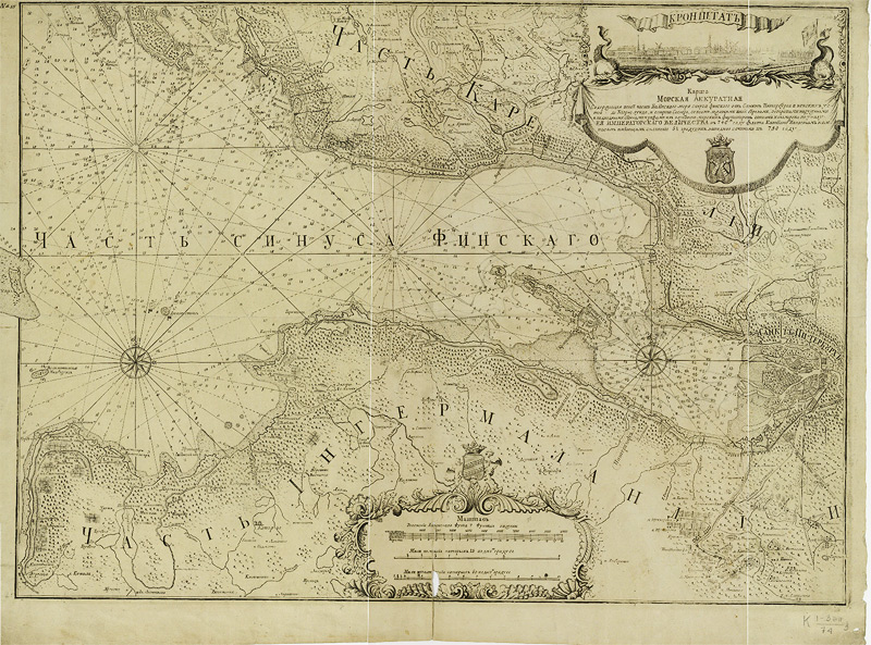
- Accurate Marine Map containing part of the Baltic Sea ... composed by Navy Captain Nagaev ... in the year 750.
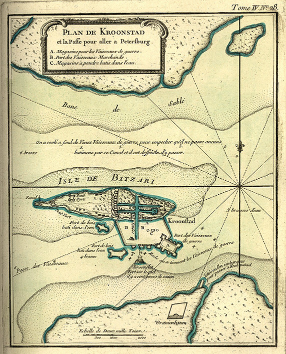
- Plan de Kronstad et la Passe pour aller a Petersburg.
- Topographic Map of Saint Petersburg
Administrative Province. Compiled by F. Schubert. St. Petersburg, 1834. Pl. 2.
- Plan de Kronstadt. Paris, [1853].
- Die bucht von Kronstadt mit Sankt Petersburg. Von H. Mahlmann. Berlin 1854.
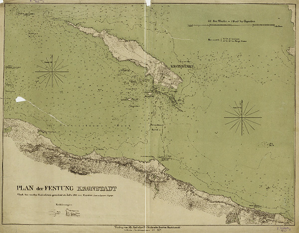
- Plan der Festung Kronstadt Nach den neusten Elufnahmen gercichnet im Jahre 1854 von Westerheid, Lieut.u.Ingenieur-Geograph. Berlin, 1854. - Berlin: 1854.
- View of the Island, Harbours and Fortifications of Kronstadt, Accompanied by Remote Views of the Mouth of the Neva River and St. Petersburg. Moscow, 1855.
- Bird's Eye View of the Island, Harbours and Fortifications of Kronstadt. St. Petersburg, 1855.
- View of Kronstadt Fortress. Moscow, 1855.
- View of Kronstadt. Moscow, 1855.
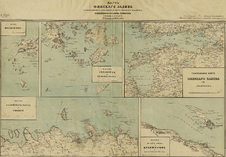
- Map of Finish Gulf showing the most important places on it in individual plans of bigger scale. Compiled by G.Ototsky. St. Petersburg. 1855.
- Kronstadt. Das Ende des Finnischen Meerbusens u S. Petersburg. S.l. 185?
- Plan of Kronstadt. The map was prepared at the Geographic Section of the Building Department of the Navy Ministry. [Moscow, 1858].
- [Military Topographic Map of Saint Petersburg Province]. [Saint Petersburg, 1863]. Line II, sheet 8.
- Plan of Kronstadt Showing Harbours and Canals Designed by Peter the Great, and the South Coast as It Appeared in 1723. [St. Petersburg, 1885].
- Environs of St. Petersburg. N 42. Kronstadt. Series: Tourist Maps of Russia. St. Petersburg, 1901.
- Plan of the Town of Kronstadt. [St. Petersburg, 1911].
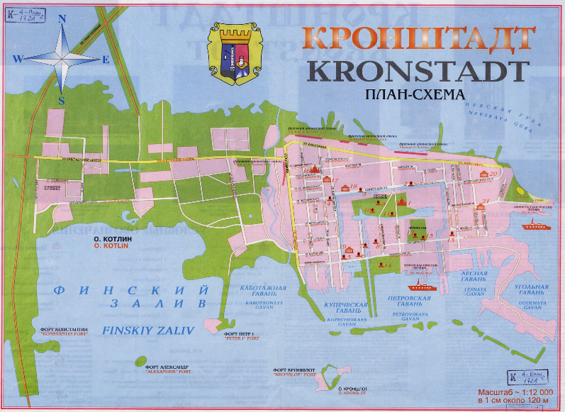
- Kronstadt. Plan-scheme. St. Petersburg, 1997.
- Kronstadt. The Center of the Town.
On the reverse side there are additional maps: Kronstadt Fortress; The Town of Kronstadt from the Plan of the Year 1887. St. Petersburg, 2000.
- Kronstadt. St. Petersburg, 2001.
Plan des Castels Cronslot im Finnischen Meer Busen nebst den fÃỳrnehmsten Vestungen an den beiden KÃỳsten derselben = Plan du Chateau de Kronslot dans le Golfe de Finnland conjointement avec les plans des plus celebres forteresses du meme Golfe. â NÃỳrnberg : HomÃĊnnischen Erben,1750 (electronic version)
The engraved image of the Kronstadt fortress was published by Heirs of Homann in 1750 after A. Schhonebeck's plate. Schhonebeck made this engraving by design of Peter the Great in 1703. Later in the same year, it served as a plan from which the model of four-storey battery was created at the town of Voronezh. The fort named Kronschlot (Germ. for "Crown's Castle") was constructed on the island of Kotlin from this model in May 1704. The flagstaff of the fort features the crown. Kronschlot defied the Swedish fleet as early as July 1704.
Additional maps: Der Finnische Meerbusen von Cronstadt bis S. Petersburg (Gulf of Finland from Kronstadt to St. Petersburg); Cronstad auf der Insel Rebusarri (Kronstadt on the island of Kotlin); Kexholm (modern Priozersk); Wiborg (Vyborg); Narva; Wilmanstrand (modern Lappeenranta, Finland); Frederichshamn (modern Hamina, Finland); Revel (Revel, modern Tallinn, Estonia).
View of the Russian fleet nearby the Island of Kotlin. Engraver Pieter Pickaerdt. [St. Petersburg,1715]
The engraving shows the Russian fleet arriving at the island of Kotlin from the campaign in the Baltic Sea, where the Russian fleet, under the command of Peter the Great, had battled with Anglo-Dutch fleets. The view depicts many galleys in the immediate foreground. Beyond are frigates and other sail vessels. The heavily wooded island of Kotlin with its buildings can be seen on the horizon.
Accurata Delineatio Sinus Finnisi Cronstadio Petropolin usque, una cum locis amoenis in litore ejus exstructis, ad exemplar Petropolitanum calamo expressit Matthaeus Seutter, Sac. Caes. Maj. Geogr. Ang. Vind. Cum Priv. Sumi Vicariat in partibus Rhem, Franc. Et Suer. Juris.
Gulf of Finland from Kronstadt to Saint Petersburg with Notable Buildings Lying along the CoastâḊ Engraver Matthaeus Seutter. [Augsburg, Seutter's Publishing House, 1742](electronic version)
The map of environs of Saint Petersburg was engraved by Matthaeus Seutter, a German cartographer and publisher. It is a replica of the well-known Russian map published by the Academy of Sciences in Saint Petersburg in 1742.
The map shows the built up area within each district of the city of Saint Petersburg and the town of Kronstadt; settlements, palace ensembles and country estates along the coast of the Gulf of Finland; roads, the coachmen's settlement and sentry boxes at the south end of Saint Petersburg, Sestroretsk factories, arable land; woodland, meadow plants, coastal shoals. The map also depicts parks and canals in the suburbs of St Petersburg - Strelna, Peterhof and Oranienbaum; as well as harbours, fortifications, buildings and other structures in Kronstadt.
At the bottom left and at the top right are the indexes where letters indicate suburbs, islands, farms, roads; figures indicate buildings and other structures at Kronstadt.
Illustrations: The view of the town of Kronstadt with the Kronslott fortress.
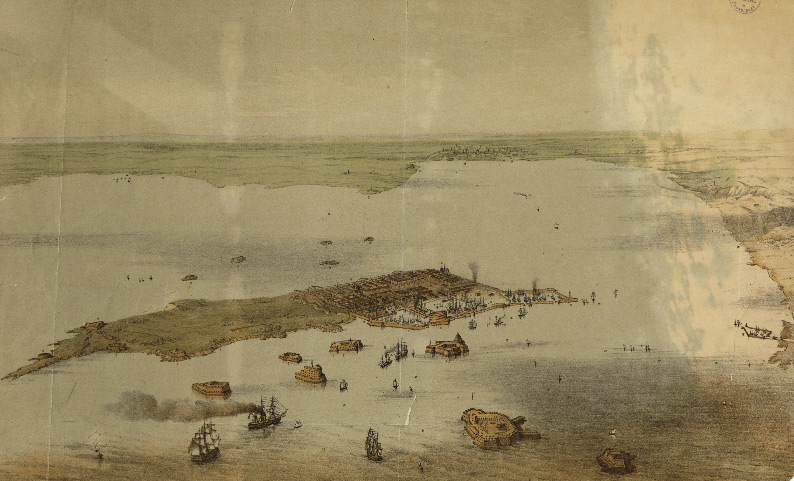
Prospect von Cronstadt. - [S. l., the latter half of the 18 century].
Perspective View of the Town of Kronstadt from South. (electronic version)
Below the view is the index where figures indicate the first palace of Emperor and the second one; new and old Russian churches, the Kronslott fortress, the harbour for naval vessels, Srednayay (Middle) and Kupecheskaya (Merchants) Harbours (1-8)âḊ
Accurate Marine Map containing part of the Baltic Sea ... composed by Naval Captain Nagaev ... in the year 750. - [St. Petersburg]: [Printing House of the Sea Cadet Corps], [1756]. (electronic version)
Plan de Kronstad et la Passe pour aller a Petersburg. [Plan of Kronstadt and the Passage to St. Petersburg].
From : Le petit Atlas Maritime Recueil de cartes et planes des quatre parties do monde en 5 volumesâḊ
Volume 4. Contenant lâErope et les divers etats quâelle renferme Excepte la France. Paris, [1853]. No. 28. (electronic version)
Topographic Map of Saint Petersburg
Administrative Province. Compiled by F. Schubert. St. Petersburg, 1834. Pl. 2. (electronic version)
The map was printed in 8 sheets. This is an extract from the second sheet.
Scale: 1 inch:5 versts (1:210 000).
The map shows the administrative boundaries between provinces, settlements, farms, roads (including small country and winter roads), rail lines with stations, post-offices, monasteries, works and factories, mills (3 types), telegraph offices, lighthouses, woodland and shrubs, marshlands.
Plan de Kronstadt avec ses fortifications, ses batteries et la portee de ses cannons dresse dâapre les documents anglais et russes les plus recents. - Paris: [1853]. - Engraving, Hand-Coloured.
(electronic version)
Supplement: Kronstad et St. Petersbourg. Shows the Gulf of Finland, Kronstadt and St. Petersburg, lighthouses, water depths, settlements along the coast, the embankment.
The plan depicts the island of Kotlin, the town districts, churches. It includes the Cathedral of St. Andrew, the Stock-exchange and Bank, the Observatory, the steam engine, the Powder Magazine, military and commercial ports, the Governor's Palace with their names; shows location and names all the forts and batteries with the number of guns in them and their arc of fire (indicated by lines), the embankment between Kronstadt and Lisy Nos built of solid granite, water depths.
Die bucht von Kronstadt mit Sankt Petersburg. Von H. Mahlmann. Berlin 1854.
Bay of Kronstadt with Saint Petersburg. By H. Mahlmann. Berlin 1854. - Berlin: 1854. (electronic version)
Conventional symbols indicate arc of fire of the fort guns (the area covered by the fire of fort guns), depth curves, the navigating waterway passable by large naval vessels, powder magazines, the saltworks, dockyards, the Exchange, the Observatory, the Peter and Catherine Canals in Kronstadt.
The map also shows the Winter palace, the new Admiralty and the previous structure, the Academy of Sciences, the Academy of Arts, the Custom House, the military school, Gostiny Dvor (a shopping center), the General Staff building, the Palace of Grand Duke Michael, the Cathedral of Our Lady of Kazan, the Cathedral of St. Nicholas, the Tauride Palace, the Smolny College (educational institute for young ladies of noble families) in Saint Petersburg.
Plan der Festung Kronstadt Nach den neusten Elufnahmen gercichnet im Jahre 1854 von Westerheid, Lieut.u.Ingenieur-Geograph. Berlin, 1854. - Berlin: 1854. (electronic version)
The plan shows the island Kotlin, town districts, churches, the Cathedral of St. Andrew, harbours, roads, vegetation, forts with their names, lighthouses, water depths.
Conventional symbols indicate warning signs, fire, rivers, houses, the powder magazine.
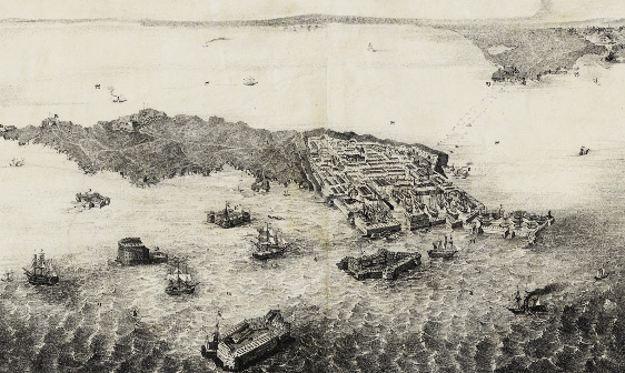
View of the Island, Harbours and Fortifications of Kronstadt, with distant views of the delta of the Neva and St. Petersburg. - Moscow: 1855. - Lithograph, b/w. (electronic version)
In the index: the Armoury, harbours, the shipyard, the lighthouse, churches, the Custom House and the Stock-exchange, the summer residence of the governor, forts with their names, the North Passage, the sandbar, etc. Drawings of ships.
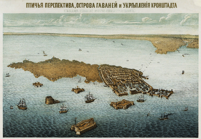
Bird's View of the Island, Harbours and Fortifications of Kronstadt (with distant views of of the delta of the Neva and St. Petersburg). - St. Petersburg in 1855. - Lithograph, hand-coloured. (electronic version)
In the index: the Armoury, harbours, the shipyard, the lighthouse, churches, the Custom House and the Stock-exchange, the summer residence of the governor, forts with their names, the North Passage, the sandbar, etc. Drawings of ships.
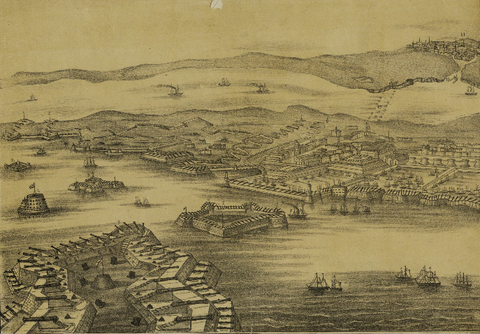
View of Kronstadt Fortress. - Moscow: 1855. - Lithograph, bicolour (electronic version)
The index contains forts with their names, harbours, the shoal, the delta of the Neva and view of St. Petersburg. Drawings of ships.
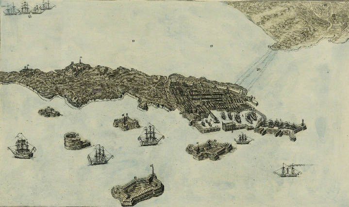
View of Kronstadt. - Moscow: 1855. - Hand-coloured (electronic version)
The index includes (wrong spelling of some names): the island of Kotnoy [Kotlin], Armoury, harbours, the bridge fortification and drawbridge, St. Andrew's Church, the Sea School, the Church of St. Nicholas, the Custom House, the Observatory, forts with their names, the residence of the governor, canals [roadsteads], "shallow water formed by sunken vehicles, stockade and pieces of granite in the North canal from Kranshtat [Kronstadt] to Lisynov [Lisy Nos]", the settlement of Lisynov [Lisy Nos], the delta of the Neva River, St. Petersburg. Drawings.
Map of the Gulf of Finland Showing the Most Important Places Lying on it. Compiled by G.Ototsky. Saint Petersburg 1855. Saint Petersburg,1855. (electronic version)
Plan of the Island of Kotlin with Kronstadt and Surrounding Forts.
From : Map the Gulf of Finland with Plans of the Bigger Scale Showing the Most Important Places Lying on It. Compiled by G.Ototsky. Saint Petersburg 1855. - Saint Petersburg: 1855.
The map depicts the island Kotlin, town districts, the fortified line? or wall, Kronslott, entrenchments, forts and batteries, the church of the Holy Trinity, the house of Commander in Chief, Kupecheskaya (Merchants), Srednayay (Middle) and Voennaya (Military) Harbours , "Small Roadstead", artilery with their names. Buildings.
Kronstadt. Das Ende des Finnischen Meerbusens u S. Petersburg. - S.l.: [1850-s]. - Lithograph, coloured. (electronic version)
The index includes: forts and batteries with their names, harbours, the lighthouse, churches, the Custom House and the Stock-exchange, the summer residence of the governor, the North Passage which became non-navigational after Peter the Great had sunk old vessels filled with granite blocks, roadsteads, the sandbar, the Cape Lisy Nos, villages along the coast. Drawings of ships.
Plan of Kronstadt / Compiled in Construction Department of the Marine Ministry. - [Moscow]: [1858]. - Lithograph. (electronic version)
The plan shows the town districs and individual buildings, the town gates with their names, Bastions (some of them with names), the Church of Our Lady of Vladimir, the Cathedral of St. Andrew, the monument to Peter the Great, the Italian pond, the swimming pool, the Peter Canal, harbours, parks and gardens with their layout, vegetable gardens and buildings outside the town walls.
[Military Topographic Map of Saint Petersburg Administrative Province]. - [Saint Petersburg]: [1863]. (electronic version)
Shows the island of Kotlin, the town districs, the fortified line? or a wall, roads, churches, the Church of Holy Trinity with its name.
Plan of Kronstadt Showing Harbours and Canals Designed by Peter the Great, and the South Coast as It Appeared in 1723.] - [1885]; [St. Petersburg]. (electronic version)
Depicts built up areas.
The index shows canals designed by Peter the Great, and the original harbour layout. The outline of the coast appears as it did in 1723.
Kronstadt. - Saint Petersburg: 1901. - Lithograph, coloured - (Russia's sightseeing map; Environs of Saint Petersburg. No. 42). (electronic version)
The map shows is the island of Kotlin, the town districts, water depths. It depicts the Catholic and English churches, the Church of Our Lady of Vladimir, the Cathedral of St. Andrew, the Observatory, the Custom House, the Sawmill and Steamship Plant, St. Petersburg and Parahodnaya Piers, the Powder Magazine, forts and batteries, Small Roadstead, East Roadstead with their names.
Supplement maps:
1. South Waterway. Ŵ.1:16800. Shows Kupecheskaya (Merchants), Srednayay (Middle) and Voennaya (Military) Harbours; Kupecheskie (Merchants), Srednie (Middle), Skvoznie(Cross-cutting), Lesnyie (Forest), Pochtovyie (Post) Gates; the Lumber the Stock-exchange, the Custom House, monuments to Pahktusov and Peter the Great, the Steamship Plant, the lighthouse and others;
2. Environs of St. Petersburg.
Plan of the Town of Kronstadt. - [Saint Petersburg]: [1913]. - Coloured (electronic version)
Shows only built up area of the island of Kotlin, the town districts with corner house numbers, churches, gardens (with their layout), street names, squares and main buildings with their names; the Barracks, the shopping center, the Charity School after Crown Prince Nicholas I, the Credit Society, the Town Council, the Civic Prison.
It depicts the Lumber the Stock-exchange, the Custom House, the Stock-exchange Yard, the Marine Engineering College, the monument to Pahktusov, the men's and women's high schools, the Office of Military Governor, the maritime arena, the Italian pond and the swimming pool, the gas works, Kupecheskaya (Merchants) Harbour.
Kronstadt: Layout. - Saint Petersburg: 1997. (electronic version)
Kronstadt: Layout. - St. Petersburg: 1997.
Conventional signs: churches, monuments and other objects, piers.
On the back is historical information, illustrations, conv. signs with the index.
Shown are the town districts, streets, harbours, forts with their names.
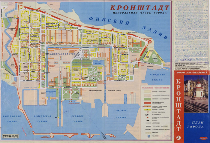
Kronstadt: Central Part of the City. - St. Petersburg: LLC "Eurokarta": 2000. (electronic version)
On the reverse side are supplement maps, the index, illustrations.
Supplement maps: 1. Kronstadt Fortress 2. Town of Kronstadt as it was depicted on the plan of 1887.
Residential districts, territories of industrial enterprises, green areas, fortifications, architecture attractions and other buildings, museums, exhibitions, monuments, design elements, guns, ladders, iron roadways, artistic fences, slopes, public conveniences are represented by conventional symbols.
The town districts with house numbers, street names, names of fortifications, towers and gates, architecture monuments and other buildings are given on the map.
Kronstadt. - Saint Petersburg: 2001. (electronic version)
On the reverse side are historical information, the table of simbols, the supplement map.
Supplement map: [Environs of Island of Kotlin]. Depicted are: the island of Kotlin, forts with names.
Shown are: the town districts, names of streets, gardens,parks etc.
![Plan des Castels Cronslot im Finnischen Meer Busen nebst den fÃỳrnehmsten Vestungen an den beiden KÃỳsten derselben = Plan du Chateau de Kronslot dans le Golfe de Finnland conjointement avec les plans des plus celebres forteresses du meme Golfe. â NÃỳrnberg : HomÃĊnnischen Erben,1750. Kronslott. Engraver Pieter Pickaerdt. [Moscow, 1703]](images/kronhlot.jpg)
![View of the Russian fleet nearby the Island of Kotlin. Engraver Pieter Pickaerdt. [St. Petersburg,1715]](images/kotlin.jpg)
![Gulf of Finland from Kronstadt to Saint Petersburg with Notable Buildings Lying along the Coast. Accurata Delineatio sinus FinniciâḊ [Augsburg, after 1742].](images/kronst-1742.jpg)
![Prospect von Cronstadt.[S.l., the latter half of the 18th century]](images/prospekt.jpg)
![Plan de Kronstadt. Paris, [1853].](images/004.jpg)
![Plan of Kronstadt. The map was prepared at the Geographic Section of the Building Department of the Navy Ministry. [Moscow, 1858].](images/013.jpg)
![[Military Topographic Map of Saint Petersburg Province]. [Saint Petersburg, 1863]. Line II, sheet 8.](images/014.jpg)
![Plan of Kronstadt Showing Harbours and Canals Designed by Peter the Great, and the South Coast as It Appeared in 1723. [St. Petersburg, 1885].](images/015.jpg)
![Plan of the Town of Kronstadt. [St. Petersburg, 1911].](images/017.jpg)