A Mirror of the World: Five Centuries of Geographical Atlases.
The exhibition, entitled Speculum Orbis Terrae: Five Centuries of Geographical Atlases in the Collections of the National Library of Russia, and a published catalogue of the same name marked the completion of the final stage of an eighteen-month project, led by the National Library of Russia in close collaboration with the Netherlands Institute in St. Petersburg, and the Netherlands Institute for Cultural Heritage. This international project was launched to help the Library safeguard
the unique masterpiece of the 16th-century Netherlandish cartography in collections of the Cartography Department: the Braun-Hogenberg's Civitates Orbis Terrarum /Atlas of World Towns/ published in Cologne in 1577-1581. Six major Dutch universities (University of Amsterdam, Free University of Amsterdam, Universities of Leiden, Utrecht, Groningen and Nijmegen), and Wilhelmina Jansen Fund supported conservation of the Atlas. In September-October 2004 the restored atlas was exhibited in public.
The exhibition traced the evolution of printed atlases, starting with the very ealiest items to modern-day compact discs.
The exhibition showcased more than eighty printed Russian and foreign atlases, which reflects the major achievements of world atlas-making from the 16th to 21st century. The most valuable exhibits included works by Claudius Ptolemy, Gerardus Mercator, Abraham Ortelius, Johannes Homann and other well known map makers.
An important part of the Cartography Department holdings is its Russian atlas collection that contains both the first publications from the time of Tsar Peter the Great and the present-day electronic collections of maps.
A special place was occupied by the restored volumes of the Braun-Hogenberg's Civitates Orbis Terrarum /Atlas of World Towns/and plans of the Dutch towns, whose universities funded the conservation of this marvellous 16th-century Netherlandish atlas.
The exhibition catalogue describes atlases, selected for the exhibition. A bibliographic description includes author, title, details of publication, number of total volumes and pages, size, printing technique, library shelfmark. A catalogue entries also provide brief information about authors and publishers, atlas contents, history of atlas creation and exceptional features. List of atlas and map titles, index of names (authors, compilers, engravers, artists, publishers), and list of sources are printed at the end of the catalogue.
The exhibition catalogue housed in the Cartography Department.
An online showcase of eighteen maps that were part of the major exhibition is available on the web:
List of atlas and map titles
- Universalior cogniti orbis tabula ex
recemtibus con confecta observationibus. [1508]. From: [Collected Maps of
Claudius Ptolemy. Rome, 1508].
- Gerardi Mercatoris et J. Hondii Atlas
ou representation du monde universel… Amsterdam, Henry Hondius, 1633. Vol. I.
- Theatrum orbis terrarum, sive Atlas Novus…Editae
Guiljl. Et Joanne Blaeu. Vol.1. Amsterdam, J. G. Blaeu, 1645.
- Systema solare et Planetarium.
[1742]. From: Atlas coelestis…exhibentur a Joh. Gabriele Doppelmaiero…
Nurnberg, Heredum Homannianorum, 1742.
- The West-India atlas or compendious description of the West-Indies… taken from actual survey actual survey …by Late Thomas Jefferis. London: R.Sayer a. J. Bennet, 1775.
- Atlas of the World's Commerce. Compiled from the latest official returns at the Edinburgh Geographical institute and edited by J.G.Bartholomew etc. London: George Newnes, [1907].
- [Portolan Atlas von Battista Agnese (1546)].
Disentis, Graz, Moscow: Desertina, Akademishe Druck-u.Verlagsanstalt, Autor, 1993.
- The –°oasts of Central America. From:[Diego Homem. Atlas Universal. 1565]. Barcelona: M. Moleiro, 2002.
- The Map of Easten Part of the Baltic Sea.
From: [Atlas of the Baltic Sea]. St. Petersburg, 1719.
- [The Map of Ingermanland, 1727.] From:
[Ivan Kirilov. Atlas of the Russian Empire. St. Petersburg, 1731.]
- The Map of St. Petersburg Province by
A. Vil'brekht. From: [Geographical Atlas of the Russian Empire],
1792.
- [Atlas of Maps and Drawings of the Voyage in North-East Part of Russia and on the Islands of the Northen Part of the Pacific Ocean by the Fleet of Capitain G.Sarychev.St. Petersburg, 1802].
- The Map of St. Petersburg Province. St. Petersburg,
1871. From the Detailed Atlas of the Russian Empire, with Plans of the Most Important Towns. St. Petersburg: A.Ilyin's Cartographic Establishment, 1871.
- Geographical and Statistical Pocket
Atlas of Russia. Adolf Marx. St. Petersburg: Adolf Marx's Publishing House, 1907.
- Atlas of Asiatic Russia. St. Petersburg:
The Migration Administration, 1914.
- Civitates orbis terrarum… Libr. 3... Col. Agr., [1581]
- Exactissima Amstelodami veteris et novissimi delineatio per F. de Wit. Amsterdam, gedr…by Fr. De Wit, [p. 1690].
- Lugduni Batavorum vulgo Leyden sic ultimo amplificati delineatio. F. de Wit. Amstelodami, 1670
Universalior cogniti orbis tabula ex recemtibus con confecta observationibus. [1508].
1 pl. 40,5—Ö 54 cm. Copperplate engraving.
Scale: [1:56 000 000]
The map of the world by Johannes Ruysch is one of the first printed map to show discoveries made on Columbus' voyage. It depicts the coast-line of South America, named the New World, and several of the islands of the West Indies. North America is not represented. This map marked a new stage in the development of map making, and is remarkable for its entire revision of cartographic canons, based on the Ptolemaic views.
electronic version
The map of the world by Johannes Ruysch is one of the first printed map to show discoveries made on Columbus' voyage. It depicts the coast-line of South America, named the New World, and several of the islands of the West Indies. North America is not represented. This map marked a new stage in the development of map making , and is remarkable for its entire revision of cartographic canons, based on the Ptolemaic views.
From: [Collection of the Maps of Claudius Ptolomaeus. Rome,1508].
1 vol. (33 map plates, without a title page) 42—Ö30 cm. Copperplate engraving.
Shelfmark: –ö 0-–ú–ł—Ä-7/345
electronic version
It was dated and described both from the copy of Ptolemy's Geographia, held in the Russian State Library in Moscow, and also from A.E.Nordenskiold's Facsimile-atlas… Vol. XXXII, Briquet C.M. [3], no. 6280.
The collection of the maps to Ptolemy's Geographia was published in Rome in 1508. Twenty seven of the thirty three maps accord with those included in the previous editions of 1478 and 1490. The maps Tabula moderna Hispaniae, Tabula moderna Franciae, Tabula moderna Italiae, Tabula moderna Terra Sanctae, Tabula moderna Prussiae, Livoniae, Norvegiae et Gotiae, Universalior cogniti… were issued in the edition of 1507 and reprinted in this edition. The last two mentioned were the first published representations of parts of Scandinavia and the coastal line of the New World, respectively. It was at the very time that the tradition of including morden maps into Ptolemy's classical work started, since the atlas as a form of publication had not yet become established. Several decades later, this practice resulted in a complete confusion of ancient and new geography.
This collection is the oldest dated atlas in the holdings of the Cartographic Department of the National Library of Russia.
Gerardi Mercatoris et J. Hondii Atlas ou representation du monde universal… Amsterdam, Henry Hondius, 1633. T. I.
1 vol. (303 pp.) 47—Ö30 cm. Copperplate engraving.
Shelfmark: –ö 0-–ú–ł—Ä-8/48
This French-language work, dating from 1633, is a reprint of Mercator's
Atlas. The celebrated world atlas of Gerardus Mercator was first issued in 1595, a year after his death. The atlas contained a treatise on the creation of the world and 107 maps with geographical descriptions, of wich 102 were compiled by Mercator himself. In 1602 the heirs of Mercator brought out a second edition of the atlas. In 1604 they sold all the copper plates from which the atlas was printed, to the Amsterdam publisher Jodocus Hondius the Elder, together with the rights to issue the atlas. Hondius continued to publish Mercator's work, constantly adding new maps and information. After Hondius' death in 1612, the atlas was continued by his sons. In 1638 publication was transferred to Jan Janssonius, who removed Mercator and Hondius' names from the title page of the
Atlas and separate maps.
In Russia, the text of the
Atlas was translated into Russian in 1630 and given the title
Cosmography in Seventy Six Chapters (Semidesyatishestiglavaya Kosmografia). In 1637, a new translation called the
Description of the Whole Earth, Lands, and Great States (Kniga glagolema sirech opisaniya sego sveta, zemel', i gosudarstv velikikh) was made by order Tsar Mikhail Fyodorovich. A third translation also appeared. These translations were not printed, but were widely read in manuscript form, they are valuable landmarks of literature of the era in translation. They were used in the compilation of the map
Description of the Whole Earth, Lands, and Great States, which was printed at the beginning of the 18th century and was extremly popular, eventually becoming a cheap popular picture known as the
Illustrated Cosmography (Litsevaya kosmografia)
(
electronic version).
Theatrum orbis terrarum, sive Atlas Novus…Editae Guiljl. Et Joanne Blaeu. T.1. Amsterdam, J. G. Blaeu, 1645.
1 vol. (295 pl.) 46—Ö31 cm. Copperplate engraving. Hand-Coloured.
Shelfmark: –ö 0-–ú–ł—Ä-8/112-1
electronic version
The
Novus Atlas is one of the most important works of Willem Blaeu, the founder of the well-known publishing house. It was originally issued in two volumes (1635), but subsequently expanded by Joan Blaeu to four volumes (this edition), and in 1655 a six-volume publication appeared. The atlas contains maps of the world, single continents, countries and parts of countries. It is accompanied by five highly coloured and extensive discriptions. Blaeu's works were unparalleled in their size and the richness of their decoration, and were a brilliant examples of the Golden Age of Dutch Cartography.
Nova totius terrarum orbis geographica ac hydrographica tabula. [1645].
1 pl. 30—Ö49 cm. Copperplate engraving. Hand-Coloured.
Scale: [1:93 000 000]
electronic version
It is one of the most impressive world maps from the seventeenth-century Dutch atlases, compiled by Blaeu and engraved by Joshua van den Enden. The map was originally published separately in 1606. From 1606 to 1658 it was included in atlases. The map shows state frontiers, countries, towns, and mountains. Supplementary maps of the Polar Regions are located in the bottom corners of the map. The map is divided into four climatic zones, based on the duration of the longest day of the year (the summer solstice), and into four latitudinal zones. The zones are designated along the edges of the map.
The decorative borders consist of allegorical representations of the Sun and Moon, the five known planets (Mercury, Venus, Mars, Jupiter, Saturn); the four basic elements (Fire, Air, Water and Earth); the seasons and the Seven Wonders of the World.
Systema solare et Planetarium. [1742].
1 pl. 50—Ö57 cm. Copperplate engraving. Hand-Coloured.
It is a scheme for the heliocentric system of the world with images of zodiac constellations. The map has a scheme for comparative sizes of the Sun and the planets, a massage to the reader, a scheme for the solar eclipse of May 12, 1776; and Ptolemaic, Tychonic and Coppernican world systems in its corners.
From: Atlas coelestis…exhibentur a Joh. Gabriele Doppelmaiero… Nurnberg,Heredum Homannianorum,1742.
1 vol. (30 pl.) 54—Ö36 cm. Copperplate engraving. Hand-Coloured.
Shelfmark: –ö 1-–ź—Ā—ā—Ä 8/5a
It is one of the first atlases of the sky, compiled on basis of the work of the German scholar Johann Doppelmeier and published by Homann. In addition to maps of the night sky with symbolic representations of constellations, the atlas includes schemes for the structure of the Solar System, schemes for the planetary motions, and a map of the Moon.
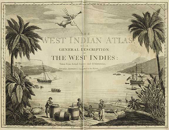
The West-India atlas or compendious description of the West-Indies… taken from actual survey actual survey …by Late Thomas Jefferis. London: R.Sayer a. J. Bennet, 1775.
1 vol. (27 pp., 39 pl.) 58—Ö40 cm. Copperplate engraving.
Shelfmark: –ö 1-–¶–ź–ľ-8/36
This atlas of the West Indies (the Caribbean region and the Pacific coast of the noth-west part of South America) was compiled by Thomas
Jefferis.
The atlas contains a detailed description of the geographical locations, populations, economies, religions of the West Indian countries, with special attention paid to trading opportunities and export goods.
Atlas of the World's Commerce.
A new series of maps with descriptive text and diagrams showing products, imports, exports commercial conditions and economic statistics of the countries of the world. Compiled from the latest official returns at the Edinburgh Geographical institute and edited by J.G.Bartholomew etc. London: George Newnes, [1907].
1 vol. (274 pp.) 39,5—Ö25 cm. Coloured. Lithograph.
Shelfmark: –ö 3-–ú–ł—Ä 7/232
The atlas gives a general idea of production and consumption of the most popular agricultural and industrial goods. The maps, diagrams and graphs show many different aspects of international trade. A large amount of statistics are also included, and there is an index with about 600 names. This was the first atlas of that kind and scope to be published in the Great Britain. Work on the atlas took several years, trade data from all of the world countries were used in its creation.
Languages of commerce.
From: Atlas of the World's Commerce.
1 pl. 21—Ö35,5 cm. Scale: [1:76 000 000].
The map depicts the distribution of languages that were prevalent in different market zones of the world, and commercial shipping routes with distances in miles.
[Portolan Atlas von Battista Agnese (1546)].
Disentis, Graz, Moscow: Desertina, Akademishe Druck-u.Verlagsanstalt, Autor, 1993.
1 vol. (21 pl.) 37,5—Ö 26 cm.
Shelfmark: –ö 4-–ú–ł—Ä-27/3306
It is a facsimile edition of a manuscript atlas by the renowned Italian map-maker Battista Agnese from the collection of the Cartography Department of the National Library of Russia, produced through the joint efforts of publishing firms in Austria, Switzerland and Russia.
Nautical navigational maps from the Middle Ages were the predecessors of Agnese's atlas, although, it is characterised by a number of new traits. The comparatively small scales of the maps, additional inland features, and the special attention paid to its artistic decoration - all this indicates that the Portolan Atlas was not suitable for use in practical navigation. It was intended primarily for libraries as a reference publication.
In this edition, one of the finest illustrations is especially interesting in connection with the origin of the term "atlas". The first person to use the word "atlas" in the title of his work was Gerardus Mercator, who also included a depiction of the Greek Titan Atlas on the title-page. The same figure can be seen in Agnese's work, although the map collection itself does not has a title.
[The –°oasts of Central America].
1 pl. 41,2—Ö53,4 cm
The map covers the north-east part of the Pacific Ocean, the coasts of Central America (California, Mexico, the Caribbean, the Isthmus of Panama) and the north-west extremity of South America.
The map has four 32-point compass roses with c–†–ĺ—Ā—Āes indicating the east which are a common feature of all Portuguese nautical charts.
There are illustrations: vessels, fishes, perspective representations of towns and figures of rulers. The map includes the coat of arms of Spain.
From: [Atlas Universal. 1565]. Barcelona: M. Moleiro, 2002
1 vol. (19 pl.) 46—Ö30 cm
Shelfmark: –ö 4-–ú–ł—Ä-28/3794
It is a facsimile edition of a manuscript atlas of the renowned Portuguese map-maker Diogo Homem from the collection of the Manuscripts Department of the National Library of Russia, produced through the joint efforts of the Library and the publishing house Manuel Moleiro Editor, in Barcelona.
The wold atlas comprises ninteenth plates (sixteen map plates, including two maps of the world, a calendar, the zodiac circle, and an –ź—Ā—ā—Äonomical table). It is the second largest atlas by Homem. This atlas was not really used aboard ship; instead, its content, scales, decoration and purpose suggests that it is an universal reference work.
The ornamentation of the atlas clearly shows traditions of the Portuguese cartographic school. All maps are characterized by drawn scales of distance in leagues and numerous ornate compass roses.
Diego Homem's atlases were some of the best works of the Golden Age of the Portuguese cartography, based on the results of many years of the Great Geographical Discoveries by the Portuguese. They are some of the impressive examples of the manuscript atlases, which were soon replaced by Dutch printed atlases.
Supplement: Atlas Universal [Commentaries]/Marques A.P., Kildushevskaya L. Barcelona, 2002.
[Atlas of the –Ď–į–Ľ—āic Sea].
Kniga rozmernaya gradusnykh kart Ost-Zee ili Varyazhskogo morya napechatana poveleniem Tsarskogo velichestva v Sanktpiterburkhe Leta gospodnya 1719. Maya v 20 den'. St.-Petersburg, 1719.
1vol. (12 pl.) 53—Ö30 cm. Copperplate engraving.
Shelfmark: –ö 1-–Ď–į–Ľ—ā 8/1
electronic version
It is the second edition of the first Russian maritime atlas. The maps were re-engraved from maps in a Swedish atlas of the –Ď–į–Ľ—āic Sea, which was compiled on the basis of surveys carried out under the supervision of Swedish ad–ú–ł—Äals Werner von Rosenfelt and Peter Gedda in the 1670s and 1680s. The first edition appeared in 1714. In 1718 and 1719 the atlas was re-issued with identical content. Three new maps, based on surveys by I.L. Lyuberas and A.N. Nagaev, were added to the later edition of the atlas, published in 1723. Only the first edition of the atlas has survived in two copies, of the other editions only a single copy remaines.
[The Map of Easten Part of the –Ď–į–Ľ—āic Sea].
Rozmernaya gradusnaya karta nad Ost-Zee ili Varyazhskim morem nachinayushchayasya ot Skagena dazhe Do nord Bodem iSankt Piters Burkha. Predely imesta pri-smotreny opisany, vvmeste svedeny, Poprilezhnomu opisaniyu Vitse Ad–ú–ł—Äala Shvetskogo Berna Rosenfelta. 1694. Godu. [1714].
From: [Atlas of the –Ď–į–Ľ—āic Sea]
1pl. 61—Ö53 cm. Copperplate engraving.
Scale: [1:1 850 000].
electronic version
The map shows states, populated places along the coast, anchorages, navigation channels, mouths of the inflowing rivers, water depths, shoals and sandbanks, rocks and reefs, compass points. Swedish coats of arms of the individual areas are also depicted on the map. The title of the map is within a decorative cartouche with an image of the crowned double-headed eagle holding oak and laurel branches in its beaks and a shield with Peter the Great's monogram in its claw, and figures of navigators with a sounding lead, a nautical map and a measuring instrument.
[Map of Ingermanland, 1727]
Siyu novuyu Idostovernuyu vsei Ingermanlandii lant kartu obderzhashchuyu vsebe Gorody kreposti slobody zavody myzy derevni melnitsy reki ozera ichast'Zaliva finskago iozera Laduzhskogo takozhde Ladozhskoi i inyia kanaly iperspektivnyia dorogi iprotchaya, yazhe vse sobrano oseleniyakh dorogakh ikanalach ponovomu v 1726 godu opisaniyu uchinennomu chrez rosiiskikh Geodezistov areki iozera slant karty pechatnoi sankt. peter burkh 1727 iyunya d.29. ...Kirilov. Grydoroval Aleksey rostovtsev. [St.-Petersburg: Synodal printing house], 1727.
1 pl. 44.5—Ö55.5 cm (52.6—Ö71.7 cm)
Copperplate engraving. Hand-Coloured.
Scale: [1:400000].
Engraver Alexei Rostovtsev.
It is a map of the area covering Yamburg, Kaporye, and Shlisselburg districts. The map shows borders of districts and their subdivisions (pogosty), populated places, factories, mills, broad roads to Moscow and Saarskaja Myza (Tsarskoye Selo), the St. Alexander Nevsky Monastery, breweries, the carpenters' settlement in the environs of St.-Petersburg, canals, islands in the delta of the Neva River, "seaside houses" along the south coast of the Gulf of Finland, Dubki palaces, the quarry near the Tosna River, Osinovaya Roshcha vacant lands and "empty pub" nearby them, tav[erns?] along the road to Moscow, the swamp in the upper reaches of the Sestra River, shoals and sandbanks.
There are the index where figures indicate names of the islands in the delta of the Neva River (1-13). The text contains I.Kirilov's dedication to Peter II, elements of the content of the map, sources used for compiling the map. A drawing of a view of Saint Petersburg (a copy from the work by Pieter Pickaerdt the Atlas of the –Ď–į–Ľ—āic Sea /Kniga rozmernaya Ost-Zee/ from 1723) is located at the top left; above is a portrait of Peter II framed by olive branches and surrounded by allegorical figures, wearing crowns and holding round shields with monograms. A decorative cartouche in the top right hand corner shows a view of Shlisselburg with the inscription "Schlutel Burg", allegorical figures, military attributes. A decorative cartouche in the bottom right hand corner has the coat of arms of the Russian Empire topped with the crown, Cupids, Tritons, one of them with a sounding lead, a depiction of the first wooden fortress in the Gulf of Finland Kronslot. At the bottom left is the coat of arms of Ingermanland supported by infants, and a river god depicted as an old man with an urn, holding a trident.
From: [Atlas of the Russian Empire, 1731]
Atlas Vse–†–ĺ—Ā—Āiiskoi Imperii v kotorom eya tsarstva, gubernii, provintsii, uezdy i granitsy skol'ko vozmogli –†–ĺ—Ā—Āiiskiya geodezisty opisat' onye v landkarty polozhit' po dline i shirote tochno iz''yavlyautsya i goroda, prigorody, monastyri, slobody, derevni, zavody, mel'nitsy, reki, morya, ozera, znatnye gory, lesa, bolota, bol'shiya dorogi i protchaya so vsyakim prilezhaniem izsledovannye –†–ĺ—Ā—Āiiskimi i latinskimi imenami podpisany imeyutsya trudom i tshchaniem Ivana Kirilova. Ves' sei Atlas rezdelen budet v tri toma i budet soderzhat' v sebe vsekh na vse 360 kart, ezheli vremya i sluchai vse onyya sobrat' i grydorom napechatat' dopustit. Dliny zachal svoe priemlyut ot pervago meridiana chrez ostrova Dagdan i Ezel' provedennogo, konchayutsya zhe v zemle Kamchatke tak chto Imperiya –†–ĺ—Ā—Āiiskaya bolee 130 gradusov prostiraetsya kotorykh ves' zemnoi globus 360 v sebe soderzhit. St.-Petersburg: [St.-Petersburg printing house, 1731].
1 vol. (10 pl.) 54—Ö37 cm.
Copperplate engraving. Hand-Coloured.
In Russian and Latin.
Shelfmark: –ö 1-–†–ĺ—Ā—Ā 8/4
It is the first atlas of Russia, created on the basis of materials from the systematic topographic instrumental survey of the whole state begun by order of Peter the Great in 1720. Ivan Kirilov managed Russia's first –ź—Ā—ā—Äogeodetic and cartographic work and himself produced several maps; he was also the initiator and organizer of the compilation of the atlas, and its publisher.
The work was left unfinished for some reasons, just thirty five maps were made, of which seven are lost. The maps include a lot of information pertaining to the country's phisical geography, administrative and political matters, while the texts provide a certain amount of economic information.
The maps are decorated with decorative cartouches. In spite of the fact that the atlas contains many inaccuracies, it has great historical and geographical value as a memorial of the early years of Russian research cartography.
[Geographical Atlas of the Russian Empire].
–†–ĺ—Ā—Āiiskoi atlas izsoroka chetyrekh kart sostoyashchii i na sorok na dva namestnichestva, imperiyu razdelyayushchii. Sochin. gravir.ipechat.pri Gornom Uchilishche 1792. Soch.–ź. Vil'brekht. Grav. Aleksei Savinkov, I. Leonov. Vyrez. T. Mikhailov. St.-Petersburg: Geographical Department of Her Imperial Majesty, 1792.
1 vol. (title-page with Catherine the Great's monogram, 90 pl.) 55—Ö44 cm
Copperplate engraving.
Shelfmark: –ö 1-–†–ĺ—Ā—Ā 8/11–į
Compiler: –źlexander Vil'brekht
Engravers: Alexei Savinkov, I. Leonov.
Carver: T. Mikhailov.
electronic version
The work was engraved and printed at the Mining Academy's engineering school in 1792. After the Academy's Atlas of 1745, it is the second largest desktop reference atlas, representing the administrative structure of the Russian Empire, established from the
New Regulations on Provinces of 1775. The atlas provides information about the density and character of populated places, about the extraction of mineral resources, about vegetation, with sub-divisions into deciduous, mixed, and evergreen forests and shrubs. In some cases, waterways are indicated down to small streams. Marshes are shown. Roads are not included. Each plate is embellished with a subject cartouche, illustrating the main occupations of the population of the represented area. In 1800 the atlas was re-issued because of changes in the country's administrative divisions.
The Map of St. Petersburg Province. Compiler –źlexander Vil'brekht.
Engraver Alexei Savinkov. [Engraver of the cartouche] G. Kharitonov. [1792].
Karta St. Peterburgskoi gubernii. Soch. Alek. Vil'brekht. Grav. Alek. Savinkov. [Grav. kartush] G. Kharitonov. [1792].
From: [Geographical Atlas of the Russian Empire]
1pl. 46—Ö57 cm.
Copperplate engraving. Hand-Coloured borders.
Scale: [1:760 000].
electronic version
The map shows borders of provinces and disricts, populated places, fishermen's houses along the coast of Lake Ladoga, fortresses, monasteries, factories, windmills, the Ladoga and Syas Canals; forests, and marshs. The map is decorated with a subject decorative cartouche, featuring allegorical images: the goddess Athena is depicted with a ceptre in the foreground; Mercury with an unrolled scroll is on bended knees before her; next to him is a globe, books, a palette and brushes; symbols of the Tsar's power are on a support; triumphal gates are to the left of the pyramid; on a pediment is an allegory of the victories over Sweden - a chained lion, a banner with the coat of arms of Sweden, tilted down in dishonour, and military attributes; above them is a soaring double-headed eagle with lightnings of Jupiter; in the opening of the gates is the figure of the Bronze Horseman (a monument to Peter the Great); in the background are sailing boats. The cartouche symbolizes the successes of Catherine's rule and the importance of St. Petersburg as the state capital, the residence of Emperors, a trading and port city, and a center for science and culture.
A Yakut shaman invoking spirits to cure a sick person.
Engraved by Englishman Sanders. 1803. To the p. 30.
1pl. 40—Ö31 cm. Copperplate engraving.
electronic version
From: [Atlas of Maps and Drawings of the Voyage in the Noth-East Part of Russia and on the Islands of the Northen Part of the Pacific Ocean by the Fleet of Captain G.Sarychev. Saint-Petersburg, 1802].
1 vol. ( 51 pl. of maps and drawings without a title-page) 43—Ö55 cm.
Copperplate engraving.
Shelfmark: –ö 2-–Ę–ł—Ö 8/54
electronic version
The atlas is a supplement to the book the Travels of Fleet Captain Sarychev in the Northeastern Part of Siberia, the Arctic Sea [Arctic Ocean] and Eastern [Pacific] Ocean in the Course of Eight Years on the Geographic and –ź—Ā—ā—Äonomical Naval Expedition under Fleet Captain Billings from 1785 to 1793 (Puteshestvie flota Kapitana Carycheva po severo-vostochnomi chasti Sibiri, Ledovitomu Moryu i Vostochnomu okeanu, v prodolzhenii os'mi let pri geograficheskoi i –ź—Ā—ā—Äonomicheskoi Morskoi ekspeditsii, byvshei pod nahal'stvom flota Kapitana Billingsa s 1785 po 1793 goda). St.-Petersburg, 1802.
During the expedition, Gavriil Sarychev made –ź—Ā—ā—Äonomical measurements and determinations and collected divers data which were used to compile new maps. Among them are maps representing part of the coast of the Arctic Ocean around the mouth of the Kolyma River, parts of the coast of the Sea of Okhotsk, parts of the coastline of Kamchatks, and also maps of several gulfs on the islands of Unalashka and Kadyak and the coast of Alaska. The Atlas comprised fifteen maps, as well as, some illustrations with views of the coastline and harbours, plus drawings depicting the appearance and
ways of living of the inhabitants of that places.
View of the merchant Shelekhov's settlement on the island Kadyak in the harbour of Manikaksyak or Three Saints.
From: [Atlas of Maps and Drawings of the Voyage in the Noth-East Part of Russia and on the Islands of the Northen Part of the Pacific Ocean by the Fleet of Captain G.Sarychev. St.-Petesburg, 1802]].
1pl. 40—Ö31 cm. Copperplate engraving.
electronic version
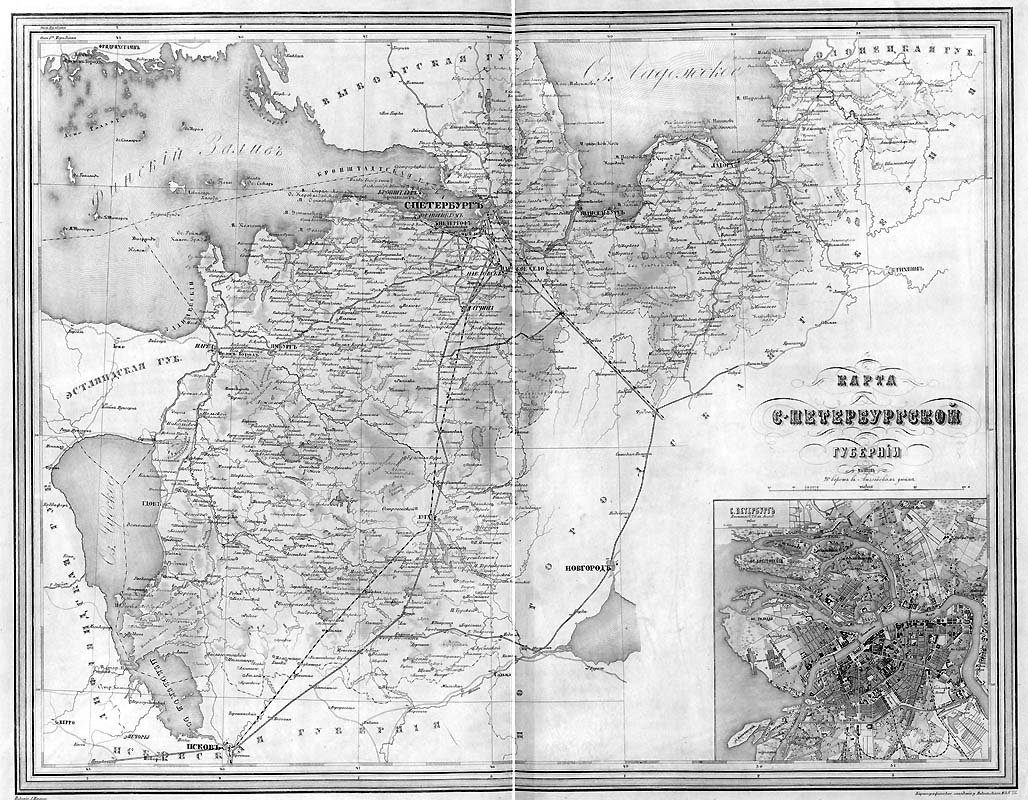
[The Map of St. Petersburg Province. Saint Petersburg, 1871].
KartaS.Peterburgskoi gubernii.Masshtab 1:840 000. St.Petersburg, 1871
1 pl. 37—Ö50 cm. Hand-Coloured borders. Lithograph.
Scale: 1:840 000.
A supllementary map: St. Petersburg.
Scale: 1:84 000.
electronic version
From: From: [he Detailed Atlas of the Russian Empire, with Plans of the Most Important Towns. Saint Petersburg: A. Ilyin's Cartographic Establishment, 1871.
1 vol. (70 pl.) 53—Ö38 cm. Hand-Coloured borders. Lithograph.
Shelfmark: –ö 3-–†–ĺ—Ā—Ā 8/306 electronic version
1 vol. (70 pl.) 53—Ö38 cm. Hand-Coloured borders. Lithograph.
Shelfmark: –ö 3-–†–ĺ—Ā—Ā 8/306
This atlas comprises general maps representing Russia's provinces, territories and regions, with plans of the most important towns. In addition, it includes several thematic maps of Russia (orohydrographical, ethnographical, administrative, etc.). The atlas is the only large publication of this kind.
[Geographical and Statistical Pocket Atlas of Russia. Adolf Marx. St.-Petersburg: Adolf Marx's Publishing House, 1907.]
Geograficheskii i statisticheskii Karmannii atlas –†–ĺ—Ā—Āii. A.F.Marks. St.Petersburg: Izdanie Tovarishchestva A.F.Marks,1907.
1 vol. (172 pp., 46 pl.) 19—Ö12 cm. Coloured. Lithograph.
Shelfmark: –ö 3-–†–ĺ—Ā—Ā 6/217
electronic version
The atlas represents the state, social and economic life of the Russian Empire in simple and popular form. Physical geography, political and administrative, ethnographic, population density, transport, land-use maps are included. Most of the information (on population, languages and dialects, popular education, natural resources, industry, trade, communication, finances) is given in tables and colourful diagrams. Illustrations show Russian flags and coins.
The idea to create the atlas was formulated by Adolf Marx. He also developed the plan for the edition and the arrangement of the material. Work on the atlas took four years.
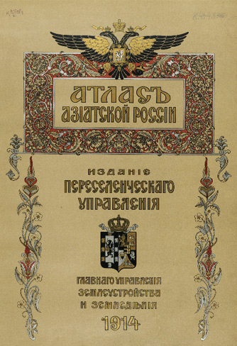
Atlas of Asiatic Russia.Published under the direction of G.V.Glinka. Text is edited by I.I.Tkhorzhevskii. Maps are under the general editorship of M.A.Tsvetkov. St. Petersburg: The Migration Administration, 1914
Atlas Aziatskoi –†–ĺ—Ā—Āii. Izdano pod rukovodstvom G.V.Glinki. Tekst redaktirovan I.I.Tkhorzhevskim. Obshchaya redaktsiya kart M.A.Tsvetkov. St. Petersburg: Pereselencheskoe Upravlenie
1 vol. (223 pp.) 55—Ö43 cm. Coloured. Lithograph.
Shelfmark: –ö 3-–°–į–∑ 8/61
electronic version
It is a composite atlas that contains more than seventy maps and diagrams, covering historical, physicogeographical and economic conditions of the area.
In addition to maps representing Asiatic Russia as a whole, there are maps of individual provinces and regions, showing land ownership and land use among migrants. Explanatory texts accompany the maps. The atlas includes an index listing more than 9 000 place-names. The edition was published by the Migration Administration and printed by the Adolf Marx's printing house.
The Atlas of Asiatic Russia is one of the finest achievements of pre-revolutionary Russian cartography.
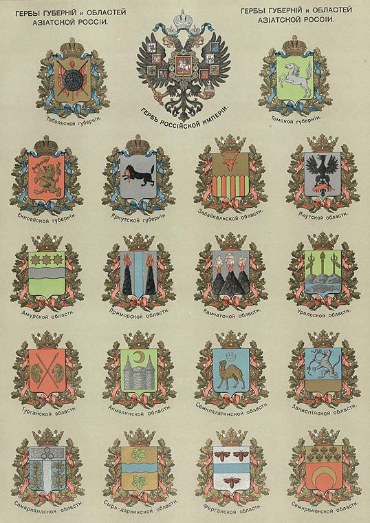
Coats of arms of the provinces and regions of Asiatic Russia.
1 pl. 34—Ö49 cm.
From: Atlas of Asiatic Russia.Published under the direction of G.V.Glinka. Text is edited by I.I.Tkhorzhevskii. Maps are under the general editorship of M.A.Tsvetkov. St. Petersburg: The Migration Administration, 1914.
1 pl. 68—Ö49 cm.
electronic version
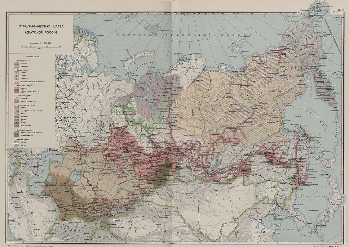
Ethnographic Map of Asiatic Russia.
From: Atlas of Asiatic Russia.Published under the direction of G.V.Glinka. Text is edited by I.I.Tkhorzhevskii. Maps are under the general editorship of M.A.Tsvetkov. St. Petersburg: The Migration Administration, 1914.
1 pl. 68—Ö49 cm. Scale: 1:12 600 000.
electronic version
This map shows the Sites of the Tribes of Asian Russia.
Civitates orbis terrarum… Libr. 3... Col. Agr., [1581]
1 vol. (136 pl.) 43—Ö31 cm. Copperplate engraving. Hand-Coloured.
Shelfmark: –ö 0-–ú–ł—Ä 7/27-3
electronic version
The
Civitates Orbis Terrarum (
Atlas of Cities of the World) by Hogenberg was the second oldest printed atlas in the history of the world cartography, and the first atlas of towns. Its principal creators and authors were the theologist and editor Georg Braun, the most important engraver and publisher Franz Hogenberg, the engraver Simon van den Neuvel, the artist and draftsman Georg (Joris) Hoefnagel, the topographer Jacob van Deventer and others. Although published outside the Netherlands, the
Civitates is, nevertheless, one of the best examples of the work of the Antwerp school of cartographers. Some of the key figures in the school were Abraham Ortelius, Gerardus Mercator, and a number of other geographers. The
Civitates reflects the Flemish style of engraving which was typical of Dutch atlases of the period. In addition, the correspondence between Braun, Hogenberg, and Ortelius contains clear indications that the idea to create the atlas was formulated by them in Antwerp.
The more than 500 maps, contained in the atlas, represent an entire era in the history of town-mapping. Six volumes of the atlas were published between 1572 and 1617. In order to obtain the originals for his work, Braun corresponded extensively with map sellers and scholars from different cities and countries. In addition, authors carried out their own investigations. Howerver, these were not true geodetic surveys, but detailed on-location drawings of panoramic views of the towns made from some high point. Most of engravings, that decorate the Civitates from its first volume to its last, were made from such drawings by Georg Hoefnagel. Hoefnagel drew the images of many towns in France, Italy, England, and Spain. He and his son Jacob subsequently created representations of Austrian and Hungarian towns for the Civitates. Besides such overview plans, the atlas includes also more detailed maps based on topographic surveys, and particularly the surveys of Jacob van Devener (15??-1575). Correspondingly, the maps show the systematic structure of the towns' building up with the perspective representation of various quarters and individual buildings.
The town is usually placed on the background, while on the foreground is the description of its surrounding countryside and the depictions of typical inhabitants of the town in every detail. These visual representations of people served for not only augmenting the contents of the maps but also for another purpose. The pages of Braun and Hogenberg's Civitates were illustrated with figures of local inhabitants to prevent the maps from being used by the Turks for military goals, since Islam forbids images of humans.
Of the total number of towns, only a couple of dozen are located outside Europe: in Asia, Africa,and south America. This is an evidence of extremely limited cartographic knowledge of the world, due to the insufficient development of science and practices of mapmaking in the second half of the sixth century. At the same time, it is impossible not to be astonished at the huge quantity - by the standards of the time - of material included in the atlas.
Braun and Hogenberg's Civitates was an enormous success. It was republished and supplemented by new sections many times. Maps contained in it became exemplary; they were frequently reproduced in a smaller format by other publishers as illustrations for books and maps.
After Franz Hogenberg's death, the typographic plates for the atlas remained in Cologne, in the possession of Abraham Hogenberg. When Abraham died in 1653, his heirs evidently sold them to Johannes Janssonius, an active and skilled publisher of books and atlases in Amsterdam. In 1657, Janssonius issued the atlas in eight volumes in a completely revised edition, with illustrations arranged by country. A large number of quite new engravings were added to it, while outdated prints were omitted. Following Janssonius's death in 1664, the engravings became the property of his grandson Johannes Janssonius van Waesberge, who used some of them to compile his own atlas, which appeared in 1682. In 1694, van Waesberge's copper plates and equipment were purchased at auction by the energetic Amsterdam publisher Frederick de Wit, who was well-known for his numerous maps and atlases. De Wit organized a new edition which was also enriched with new engavings.
After de Wit's time, at the turn of the eighteenth century, the copper plates for the atlas passed into the hand of the publisher Pieter van der Aa (1659 - 1733). He acquired them in Leyden and used for an atlas which came out in 1729. This publication included a diverse mixture of engraving from the sixteenth to eighteenth centuries.
After van der Aa, ownership of town maps with publisher's imprint of de Wit passed to the publishing house of Covens and Mortier. The multiple reproductions by various publishers of these 16th-century perspective views and maps over centuries can be explained by their rich historical and geographical content. At the same time, it is necessary to say that there is no atlas of the world's cities in the history of global cartography to equal the Civitates Orbis Terrarum in its size and fullness.
In addition to its historical, geographical, and cartographic significance, the Civitates is also of great artistic value. That is why, up until now, the town-maps, contained in the atlas, have adorned the most exquisite interiors and attracted the attention not only of specialists in the field, but of all ad–ú–ł—Äers of fine art.
Mola. [1588]
From: Civitates orbis terrarum… Libr. 3... Col. Agr., [1581]
1 pl. 30—Ö43 cm. Copperplate engraving. Hand-Coloured.
electronic version
It is shows the immediate environs of the Italian town of Mola (Mola di Bari). In the bottom left corner are depicted figures of Georg Hoefnagel and Abraham Ortelius.
Cairos qvae olim Babylon...
1 pl. 30—Ö43 cm. Copperplate engraving. Hand-Coloured.
electronic version
It is a map of Cairo.
Exactissima Amstelodami veteris et novissimi delineatio per F. de Wit. Amsterdam, gedr…by Fr. De Wit, [c. 1690].
1 pl. 53—Ö63 cm. Copperplate engraving.
Oriented: South-west.
Scale: [1:3 000].
Shelfmark: K 0-–ē–≤–Ņ–Ľ 2/1012
electronic version
The plan of Amsterdam was compiled and published by the Dutch map-maker and publisher Frederick de Wit. The plan shows the town walls, fortifications, bastions, built-up areas, streets, bridges, public buildings, windmills, the port, wharves, docks, shipyards, and gardens. Below is a perspective view of Amsterdam (
Amstelodami prospectus) in a cartouche. At the top left is the coat-of-arms of Amsterdam; the seal of Amsterdam is to the right.
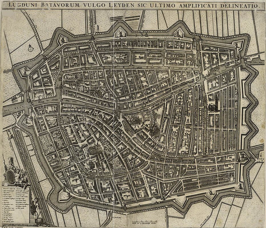
Lugduni Batavorum vulgo Leyden sic ultimo amplificati delineatio. F. de Wit. Amstelodami, 1670?
1 pl. 51—Ö59 cm. Copperplate engraving.
Oriented: North-east.
Scale: [1:5 000].
Shelfmark: –ö 0-–ē–≤–Ņ–Ľ 2/345
K 0-–ē–≤–Ņ–Ľ 2/345
electronic version
It is a perspective plan of Leiden, compiled and published by the Dutch map-maker and publisher Frederick de Wit. The plan shows fortifications, built-up areas, the town gates, individual buildings, canals, bridges, mills, gardens, and roads.
The plan includes an index within a decorative cartouche with the coat-of-arms of Amsterdam.
![Universalior cogniti orbis tabula ex recemtibus con confecta observationibus. [1508]. From: [Collected Maps of Claudius Ptolemy. Rome, 1508].](images/ruish.jpg)
![Systema solare et Planetarium. [1742]. From: Atlas coelestis…exhibentur a Joh. Gabriele Doppelmaiero… Nurnberg, Heredum Homannianorum, 1742.](images/gelios.jpg)
![Atlas of the World's Commerce. Compiled from the latest official returns at the Edinburgh Geographical institute and edited by J.G.Bartholomew etc. London: George Newnes, [1907].](images/comerstit1.jpg)
![Atlas of the World's Commerce. Compiled from the latest official returns at the Edinburgh Geographical institute and edited by J.G.Bartholomew etc. London: George Newnes, [1907].](images/comerskart.jpg)
![[Portolan Atlas von Battista Agnese (1546)]. Disentis, Graz, Moscow: Desertina, Akademishe Druck-u.Verlagsanstalt, Autor, 1993.](images/portol.jpg)
![The –°oasts of Central America. From:[Diego Homem. Atlas Universal. 1565]. Barcelona: M. Moleiro, 2002.](images/homem.jpg)
![The Map of Easten Part of the Baltic Sea. From: [Atlas of the Baltic Sea]. St. Petersburg, 1719.](images/varjagtit.jpg)
![The Map of Easten Part of the Baltic Sea. From: [Atlas of the Baltic Sea]. St. Petersburg, 1719..](images/varjag.jpg)
![[The Map of Ingermanland, 1727.] From: [Ivan Kirilov. Atlas of the Russian Empire. St. Petersburg, 1731.]](images/kiril.jpg)
![The Map of St. Petersburg Province by A. Vil'brekht. From: [Geographical Atlas of the Russian Empire], 1792.](images/rosatltit.jpg)
![The Map of St. Petersburg Province by A. Vil'brekht. From: [Geographical Atlas of the Russian Empire], 1792.](images/rosatlkart.jpg)
![[Atlas of Maps and Drawings of the Voyage in North-East Part of Russia and on the Islands of the Northen Part of the Pacific Ocean by the Fleet of Capitain G.Sarychev.St. Petersburg, 1802].](images/puteshest.jpg)
![Atlas of Maps and Drawings of the Voyage in North-East Part of Russia and on the Islands of the Northen Part of the Pacific Ocean by the Fleet of Capitain G.Sarychev.St. Petersburg, 1802].](images/puteshest2.jpg)
![Civitates orbis terrarum… Libr. 3... Col. Agr., [1581]](images/orbistit.jpg)
![Civitates orbis terrarum… Libr. 3... Col. Agr., [1581]](images/orbismola.jpg)
![Civitates orbis terrarum… Libr. 3... Col. Agr., [1581]](images/orbiskair.jpg)
![Exactissima Amstelodami veteris et novissimi delineatio per F. de Wit. Amsterdam, gedr…by Fr. De Wit, [p. 1690].](images/amster.jpg)