Terra Australis Incognita – the Unknown Southen Land was a hypothetical continent supposed to exist at the extreme south of the known world. Other names for this putative land have included Terra Australis, Terra Australis Nondum Cognita (Latin for "The Southern Land Not Yet Known"), Brasiliae Australis, Magallanica или Magellanica ("the land of Magellan"), La Australia del Espíritu Santo (Spanish for "the Southern Land of the Holy Spirit") etc.
Subsequently, the term Terra Australis gave the name to the continent Australia. Since ancient times, most maps showed Terra Australis as a large land mass centred on the South Pole. According to the ideas of the ancients, it had to balance the huge continental mass of the Northern Hemisphere. An unknown land was depicted on map until the second half of the 18th century, although, at the time, no evidence of its existence was found.
The outlines of the continent was depicted arbitrary, it often was combined with South America or Australia. Mountains, forests and rivers were often featured on it. In the 18th century, because of increased requirements for the reliability of the source data for mapping, the supposed continent ceased to be shown on maps.
Antarctica was opened in 1820 by the expedition of the Imperial Russian Navy led by Thaddeus von Bellingshaus and Mikhail Lazarev.
History of the mapping of the Unknown Southern Land - Antarctica is a rare case when the invented territory exists in reality.
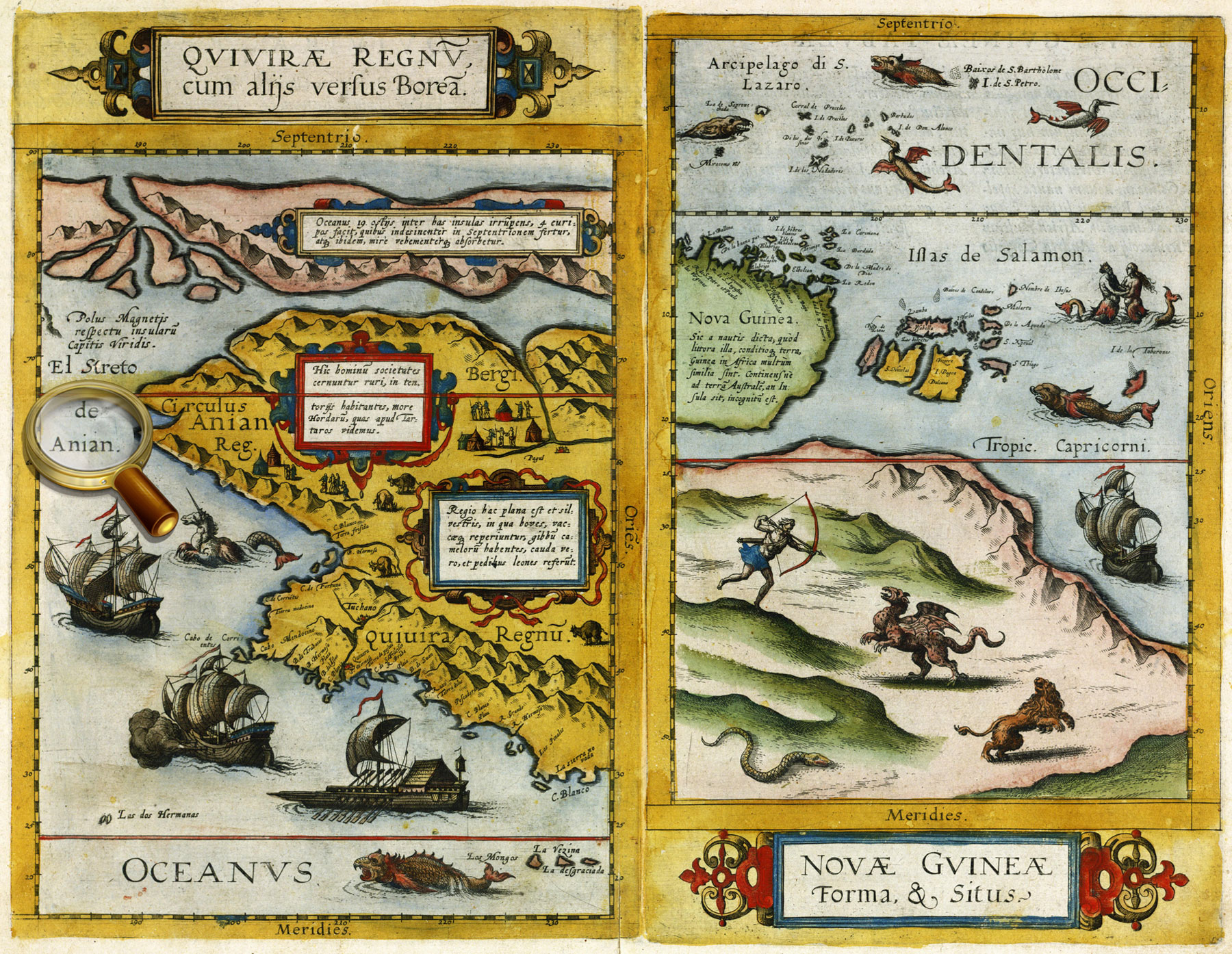
Strait Aniane
The Strait Aniane (El Streto de Anian) was suggested to separate the American continent from Asia, it began to be depicted on maps in the beginning of the 16th century.
For the first time the name "Aniane" appeared in a work of Italian map- maker J. Gastaldi in 1562. It is noteworthy that on the map of the Dutch cartographer Gerard de Jode , compiled in the Latin language, the name of the strait is given in Italian. It is also known that the Western European cartographers of the 16th-17th centuries actively used the Russian sources, so it can be assumed that information, penetrating to Europe from Muscovy, contributed to the origin of the legend of the Strait Aniane, and the place-name "Aniane" was derived from a corrupted Russion word for "Ocean".
As it is known, in the early 16th century, F. Magellan made his first voyage around the world and discovered the strait that connects the Atlantic Ocean to the Pacific. After that, some explorers and scientists speculated that if there was a strait in the south of the American continent, the similar strait had to locate in the north.
In fact Cossacks S. Dezhnyov and F. Popov first discovered the strait separating Asia from America, during their fishing expedition in 1648, but the strait was named after the Russian navigator Vitus Bering whose expedition passed through it in 1728.
History of the mapping of the Strait Aniane - Bering Strait is a rare case when the invented territory exists in reality.
Septentrionalium Terrarum descriptio. From the atlas: Atlas sive Cosmographicæ Meditationes…Duisburg, 1595. P. 1.
Map of the North Pole from the world atlas of Gerardus Mercator "Atlas or cosmographical meditations upon the creation of the universe, and the universe as created", Duisburg, 1595.
One of the four polar islands has an inscription, 'It is home to the pygmies' that some sources interpreted as an indication of the legendary Hyperborea. K 0-Mir 7/10 Veiw in the Digital Library
Septentrionalium regionum descrip. From the atlas: Theatrum orbis terrarum. Antverpen, 1570. P. 45.
Map of the Scandinavia from Abraham Ortelius' atlas «Theatre of the World», published in Antwerp in 1570.
One of the four polar islands has an inscription, 'It is home to the pygmies' that some sources interpreted as an indication of the legendary Hyperborea. К 0-Мир 7/11 Veiw in the Digital Library
Quivirae regnum, cum aliis versus Boream. Novae Gvineae Forma & Situs. From the atlas: Speculum orbis terrӕ. Antverpea, 1593-1613. P. 12.
Maps of part of North America (Quivira) and New Guinea from the world atlas Gerard de Jode «Mirror of the World». Antwerp, 1593-1613. P.12.
The map of Quivira contains a text in which residents of the area are compared with the Tatars – a reference to the theory that North America was part of Asia and was populated by immigrants from Asia.
К 0-Мир 7/9 Veiw in the Digital Library
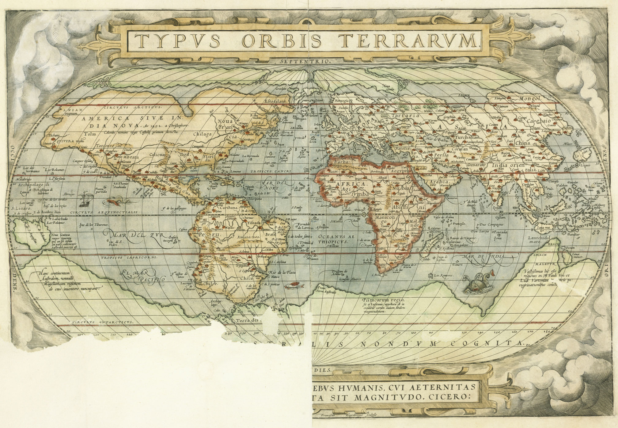
Typus orbis terrarum. From the atlas: Theatrum orbis terrarum. Antverpen, 1570. P. 1.
World map from Abraham Ortelius' atlas «Theatre of the World», published in Antwerp in 1570
К 0-Мир 7/11 Veiw in the Digital Library
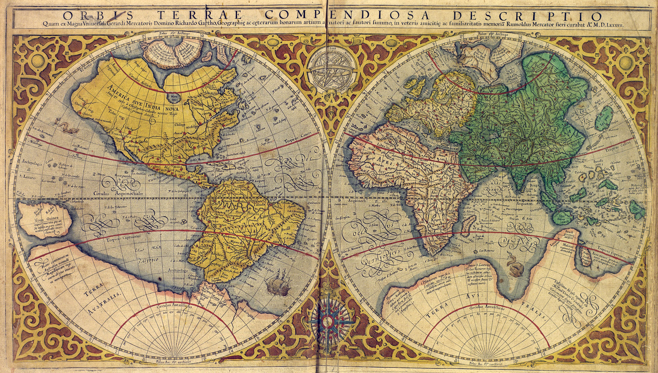
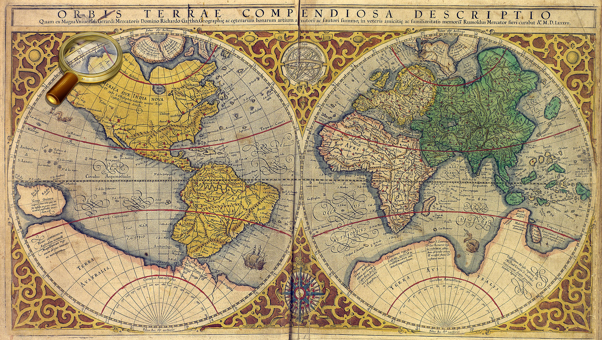
Orbis terrae compendiosa descriptio. From the atlas: Atlas sive Cosmographicæ Meditationes…Duisburg, 1595. [P. 1].
World map from the world atlas of Gerardus Mercator "Atlas or cosmographical meditations upon the creation of the universe, and the universe as created", Duisburg, 1595.
К 0-Мир 7/10 Veiw in the Digital Library
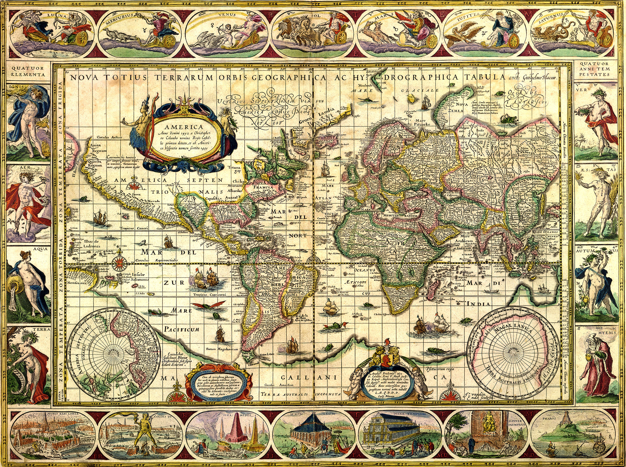
Nova totius terrarum orbis geographica ac hydrographica tabula. Auct. Guilj. Blaeuw. From the atlas: Theatrum orbis terrarum, Sive Atlas novus …Vol. 1. Amsterdam: J. G. Blaeu, 1645.
World map from Vol.1 of Joan Blaeu's atlas, published in Amsterdam in 1645 К 0-Мир 8/112_1 Veiw in the Digital Library
L’ Amerique Septentrionale Suivant les Nouvelles observations de mess-rs de l’ Academie Royale des Sciences etc, augmentees de nouveau. Avec privil.. - Leide : chez Pierre van der Aa, 16…?].
Map of North America. К 0-САм 1/3 Veiw in the Digital Library
Americae Pars Borealis, Florida, Baccalaos, Canada, Corterealis…From the atlas: Speculum orbis terrӕ. Antverpiae, 1593-1613. P. 11.
Map of part of North America from the world atlas Gerard de Jode «Mirror of the World». Antwerp, 1593-1613. P.11. К 0-Мир 7/9 Veiw in the Digital Library
Orbis terrae compendiosa descriptio. From the atlas: Atlas sive Cosmographicæ Meditationes…Duisburg, 1595. [P. 1].
World map from the world atlas of Gerardus Mercator "Atlas or cosmographical meditations upon the creation of the universe, and the universe as created", Duisburg, 1595.
К 0-Мир 7/10 Veiw in the Digital Library
L’ Amerique Septentrionale. M. Ogier fecit.. - S.l., [late 17th cent.]. Map of North America. К 0-САм 1/4 Veiw in the Digital Library
L’ Amerique Septentrionale Suivant les Nouvelles observations de mess-rs de l’ Academie Royale des Sciences etc, augmentees de nouveau. Avec privil.. - Leide : chez Pierre van der Aa, 16…?].
Map of North America. К 0-САм 1/3 Veiw in the Digital Library
Americae Pars Borealis, Florida, Baccalaos, Canada, Corterealis…From the atlas: Speculum orbis terrӕ. Antverpiae, 1593-1613. P. 12. Map of part of North America from the world atlas Gerard de Jode «Mirror of the World». Antwerp, 1593-1613. P. 11. К 0-Мир 7/9 Veiw in the Digital Library
Orbis terrae compendiosa descriptio. From the atlas: Atlas sive Cosmographicæ Meditationes…Duisburg, 1595. [P. 1].
World map from the world atlas of Gerardus Mercator "Atlas or cosmographical meditations upon the creation of the universe, and the universe as created", Duisburg, 1595.
К 0-Мир 7/10 Veiw in the Digital Library
Americae nova tabula. Auct. Guiljelmo Blaeuw. From the atlas: Theatrum Orbis Terrarum, sive Atlas Novus. Vol. 2. Amsterdam : Apud Iohanem Guiljelmi F. Blaeu, 1645. Map of North and South America from Vol. 2 of Joan Blaeu's atlas, published in Amsterdam in 1645 К 0-Мир 8/112_2 Veiw in the Digital Library
Americaу Pars Meridionalis. – Amstelodami: J. Janssoniy, [after 1630 Map of South America From Johannes Janssonius' atlas, published in Amsterdam in 1630. On the shore of Lakes Parime, there is an inscription "Manoa, or El Dorado. К 0-ЮАм 2/21 Veiw in the Digital Library
Americae nova tabula. Auct. Guiljelmo Blaeuw. From the atlas: Theatrum Orbis Terrarum, sive Atlas Novus. Vol. 2. Amsterdam: J/ G. Blaeu, 1645.
Map of North and South America from Vol. 2 of Joan Blaeu's atlas, published in Amsterdam in 1645 К 0-Мир 8/112_2 Veiw in the Digital Library
Le Perou et le cours de la Riv.re Amazone. Par N.Sanson d’Abbeville Geographe ord.-re du Roy. [Paris, 1683].
On the shore of Lake Parime (Parime) is an inscription «Manoa, or Eldorado». К 0-ЮАм 1/3 Veiw in the Digital Library
America Meridionalis Concinnata juxta Observayiones… Per G. de l'Isle. Augustæ Vindel, Vol. C. Lotter, [1770].
Map of South America, compiled by G. Delisle in 1700, and reprinted by the Lotter publishing house after 1760 The legendary country Eldorado is marked on the area called Terra Firma («mainland province» of Spain in contrast to the neighboring island colonies of Spain), present-day part of Venezuela and Colombia. К 1-ЮАм 2/27 Veiw in the Digital Library
[Madagascar, North-East Africa, Red Sea, Arabia] from the facsimile of the Atlas Universal. Diogo Homem, [1565. Barselona, 2000. Map of 8.]
The map shows the east coast of Africa. A figure of the Christian king [Prester John], often shown on the maps of the 15th-16th centuries, is placed in the center, in what is now Ethiopia. К 4-Мир 28/3794
Russia cum confinÿs. Per Gerardum Mercatorem. Cum privilegio. [Amsterdam, 1633].
Map of Russia from the atlas of G. Mercator – J. Hondius, Amsterdam, 1633.
One of the earliest map Russia, created by foreign cartographers. On the territory of the Asian part of Russia, there is depicted Lucomoria.
К 0-МоскЕ 2/19 Veiw in the Digital Library
Novissima Russiae Tabula….. Authore Isaaco Massa. Amstelodami, Hen. Hondius, sumptibus Joannis Janssonii. - Amstelodami : Hen. Hondius, sumptibus Joannis Janssonii, [1644]
Map of Russia From the atlas мира J. Hondius- J.Janssonius, Amsterdam, 1644.
One of the earliest map Russia, created by foreign cartographers. On the territory of the Asian part of Russia, there is depicted Lucomoria. К 0-МоскЕ 2/40 Veiw in the Digital Library
La Russie Blanche ou Moscovie Divisée suivant l’Etendu des Royaumes, Duchés, Principautés etc. Presenté à Monseigneur le Duc de Bourgogne par… H.Jaillot. - Paris, 1695.
One of the earliest map Russia, created by foreign cartographers. On the territory of the Asian part of Russia, there is depicted Lucomoria. К 0-МоскЕ 2/50 Veiw in the Digital Library
Carte Tartarie. Dressée sur les Relations de plusieurs Voyageurs de differentes Nations et sur quelques observations qui ont été faites dans ce pais là Par Guillaume de l'Isle Avec Privil. Amsterdam, chez J. Covens et C. Mortier [1720?].
Map of Tartary, compiled by G. Delisle using materials of many travelers, and published in Amsterdamе in ca. 1720. In the northern part of the map , there is an inscription «Lukomoria».
Septentrionalium Terrarum descriptio. From the atlas: Atlas sive Cosmographicæ Meditationes…Duisburg, 1595. P. 1. Map of Noth Pole from the world atlas of Gerardus Mercator "Atlas or cosmographical meditations upon the creation of the universe, and the universe as created", Duisburg, 1595.
Island Friesland is shown on the map at the bottom, on the left of Iceland, and is given an supplementary map on the top left. К 0-Мир 7/10 Veiw in the Digital Library
Typus orbis terrarum. From the atlas: Theatrum orbis terrarum. Antverpen, 1570. P. 1.
World map from Abraham Ortelius' atlas «Theatre of the World», Antwerp, 1570. К 0-Мир 7/11 Veiw in the Digital Library
Septentrionalium regionum descrip. From the atlas: Theatrum orbis terrarum. Antverpen, 1570. P. 45.
Map of Scandinavia from Abraham Ortelius' atlas «Theatre of the World», Antwerp, 1570. К 0-Мир 7/11 Veiw in the Digital Library
Nova totius terrarum orbis geographica ac hydrographica tabula. Auct. Guiljelmo Blaeuw. From the atlas: Theatrum orbis terrarum, Sive Atlas novus …Vol. 1. Amsterdam: J. G. Blaeu, 1645.
World map from Vol.1 of Joan Blaeu's atlas, published in Amsterdam in 1645 К 0-Мир 8/112_1 Veiw in the Digital Library
Typus orbis terrarum. From the atlas: Theatrum orbis terrarum. Antverpen, 1570. P. 1.
World map from Abraham Ortelius' atlas «Theatre of the World», Antwerp, 1570. К 0-Мир 7/11 Veiw in the Digital Library
Septentrionalium regionum descrip. From the atlas: Theatrum orbis terrarum. Antverpen, 1570. P. 45.
Map of Scandinavia from Abraham Ortelius' atlas «Theatre of the World», Antwerp, 1570. К 0-Мир 7/11 Veiw in the Digital Library
Septentrionalium regionum descrip. From the atlas: Theatrum orbis terrarum. Antverpen, 1570. P. 45.
Map of Scandinavia from Abraham Ortelius' atlas «Theatre of the World», Antwerp, 1570. Replica. К 0-Мир 7/11 Veiw in the Digital Library
Nova totius terrarum orbis geographica ac hydrographica tabula. Auct. Guiljelmo Blaeuw. From the atlas: Theatrum orbis terrarum, Sive Atlas novus …Vol. 1. Amsterdam: J. G. Blaeu, 1645.
World map from Vol.1 of Joan Blaeu's atlas, published in Amsterdam in 1645 К 0-Мир 8/112_1 Veiw in the Digital Library
[Carta marine… Anno 1539,… Olaus Magnus…] Romæ, Antony Lafrery, 1572.
Replica. «Carta Marina» is one of the earliest and most reliable historical maps of North Europe, created by the Swedish church figure, diplomat and writer Olaus Magnus. He used as personal travel notes, cards Scandinavian sailors and maps from Ptolemy's Geography as the sources for the map. Besides a detailed picture of geographic features, the map contains more than 100 miniatures depicting real and imaginary animals, local customs and costumes, historical events, and fabulous lands, including - the island Thule (Tile). К 0-Ск 3/36 Veiw in the Digital Library
Septentrionalium regionum descrip. From the atlas: Theatrum orbis terrarum. Antverpen, 1570. P. 45.
Map of Scandinavia from Abraham Ortelius' atlas «Theatre of the World», Antwerp, 1570. К 0-Мир 7/11 Veiw in the Digital Library
Septentrionalium Terrarum descriptio. From the atlas: Atlas sive Cosmographicæ Meditationes…Duisburg, 1595. P. 1. Map of North Pole from the world atlas of Gerardus Mercator "Atlas or cosmographical meditations upon the creation of the universe, and the universe as created", Duisburg, 1595.
In the center of the map, there was dipicted the Black Rock (Rupes Nigra) located at the North Pole and having magnetic properties, according to Mercator, which has magnetic properties. In addition, based on his studies of the magnetic poles and the researches of other scientists, Gerardus Mercator mapped two islands indicated as magnetic: rocky one and a very small isle shown as a circle. К 0-Мир 7/10 Veiw in the Digital Library
The latest map of Eastern Siberia, compiled in 1816. [Without place], 1816.
On the map, in the Arctic Ocean, there is an inscription, 'Land seen by Sannikov' К 2-Сиб 1/12 Veiw in the Digital Library
Map of Asiatic part of Russia and Turkestan region. To the project of the South-Siberian Railroad Orsk-Pavlodar-Barnaul by the engineer P.I. Rashevsky, dated to 1913. [Without place], 1913. The map shows Sannikov Land in the Arctic Ocean. К 3-Сиб 3/38 Veiw in the Digital Library
Map of polar regions of the Asian and American continents. Compiled by Prince Alexey Dolgoruky according to the testimony of clairvoyants. [St. Petersburg], Lithography of J. Lapping, 1852. К 3-Арк 1/25 Veiw in the Digital Library
Illustration to the article: B.S. Lukshin. Arctic knot of military-political relations between US and Russia /
Pacific Ocean. South part. From the atlas: Marine Atlas. Editor-in-chief Professor Fleet Admiral I.S. Isakov. Vol.1. Navigational and Geographical. [P.6 ], Naval General Staff, 1950-1963. The map shows Reef Maria Teresa in the Pacific Ocean. К 4-Мир 8/796
Octava Europe Tabula. From the atlas: [Collection of maps of Claudius Ptolemy. Rome, 1508. Map 8.].
Eight map of Europe [Collection of maps of Claudius Ptolemy. Rome, 1508].
The map shows the area between the Baltic Sea (with parts of Scandinavia) and the Black Sea (with the Crimean peninsula). The legendary Riphean Mountains are shown on the territory of the European Sarmatia. К 0-Мир 7/345 Veiw in the Digital Library
America Pars Meridionalis. – Amstelodami: J. Janssoniy, [after 1630].
Map of South America, compiled for Johannes Janssonius' atlas published in Amsterdam in 1630.
К 0-ЮАм 2/21 Veiw in the Digital Library
Americae nova tabula. Auct. Guiljelmo Blaeuw. From the atlas: Theatrum Orbis Terrarum, sive Atlas Novus. Vol. 2. Amsterdam : Apud Iohanem Guiljelmi F. Blaeu, 1645-1650.
Map of North and South America from Vol.2 Willem Blaeu's atlas. К 0-Мир 8/112_2 Veiw in the Digital Library
Typus orbis terrarum. From the atlas: Theatrum orbis terrarum. Antverpen, 1570. P. 1.
World map from Abraham Ortelius' atlas «Theatre of the World», Antwerp, 1570. «Terra Australis Nondum Cognita» is shown at the bottom of the map.
К 0-Мир 7/11 Veiw in the Digital Library
Orbis terrae compendiosa descriptio. From the atlas: Atlas sive Cosmographicæ Meditationes…Duisburg, 1595. [P. 1].
World map from the world atlas of Gerardus Mercator "Atlas or cosmographical meditations upon the creation of the universe, and the universe as created", Duisburg, 1595.
«Terra Australis» is shown at the bottom of the map. К 0-Мир 7/10 Veiw in the Digital Library
Nova totius terrarum orbis geographica ac hydrographica tabula. Auct. Guiljelmo Blaeuw. From the atlas: Theatrum orbis terrarum, Sive Atlas novus …Vol. 1. Amsterdam: J. G. Blaeu, 1645.
World map from Vol.1 of Joan Blaeu's atlas, published in Amsterdam in 1645
«Magallanica. Terra Australis Incognita» is shown at the bottom of the map and on the right of the supplementary map. К 0-Мир 8/112_1 Veiw in the Digital Library
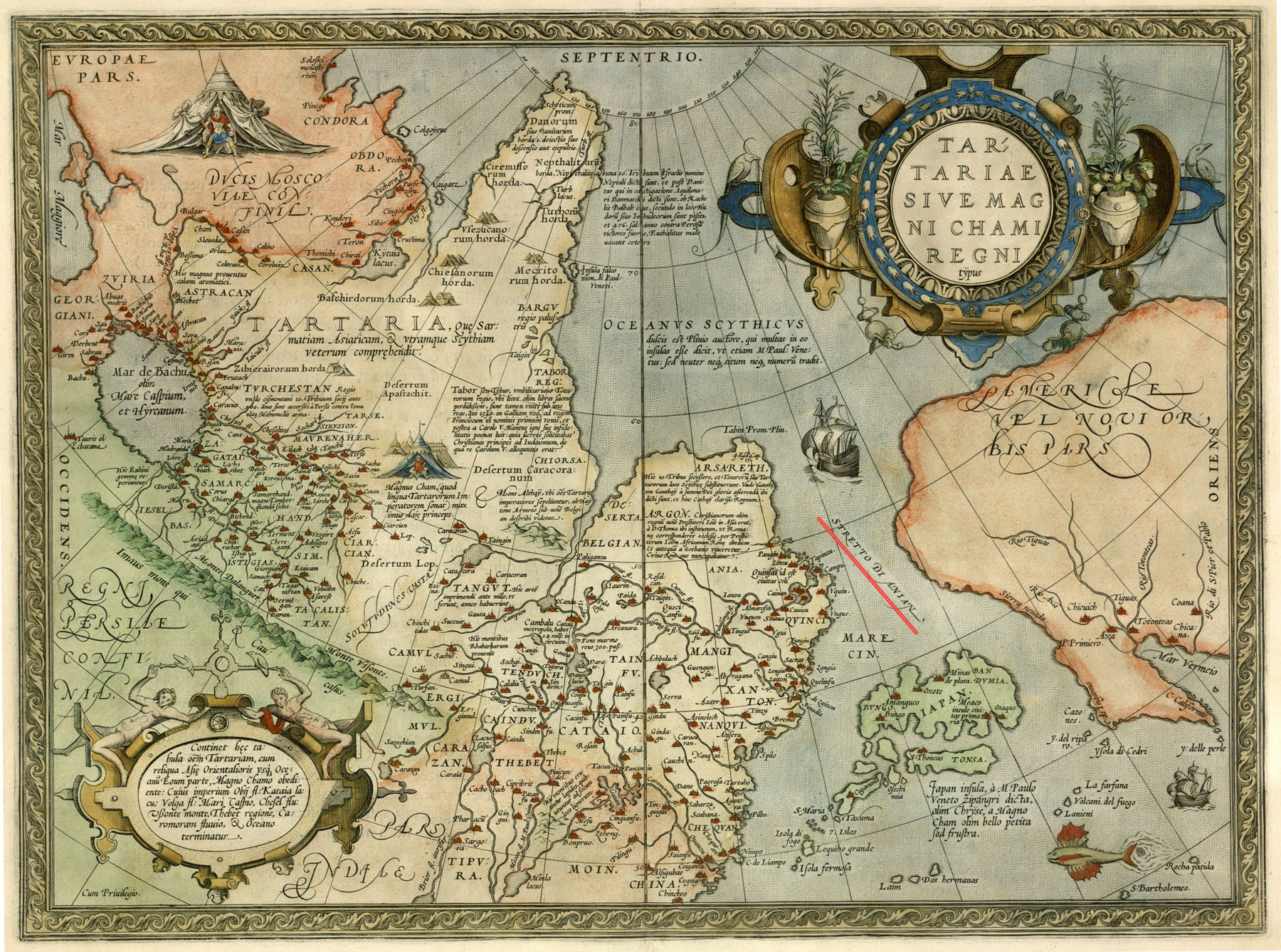
Tartariae sive magni chami regni. From the atlas: Theatrum orbis terrarum. Antverpen, 1570. [P. 47]
Map of Tartary or the Kingdom of Great Ham from Abraham Ortelius' atlas «Theatre of the World», Antwerp, 1570.
The map shows the north-eastern part of Asia and the north-western part of America, separated by the Strait Aniane.
К 0-Мир 7/11 Veiw in the Digital Library
Quivirae regnum cum aliis versus Boream. Nоvae Gvineae Forma & Situs. From the atlas: Speculum orbis terrӕ. Antverpen, 1593-1613. P. 12.
Maps of part of North America (Quivira) and New Guinea from the world atlas Gerard de Jode «Mirror of the World». Antwerp, 1593-1613. P. 12.
К 0-Мир 7/9 Veiw in the Digital Library
Orbis terrae compendiosa descriptio. From the atlas: Atlas sive Cosmographicæ Meditationes…Duisburg, 1595. [P. 1].
World map from the world atlas of Gerardus Mercator "Atlas or cosmographical meditations upon the creation of the universe, and the universe as created", Duisburg, 1595.
К 0-Мир 7/10 Veiw in the Digital Library
Nova totius terrarum orbis geographica ac hydrographica tabula. Auct. Guiljelmo Blaeuw. From the atlas: Theatrum orbis terrarum, Sive Atlas novus …Vol. 1. Amsterdam: J. G. Blaeu, 1645.
World map from Vol.1 of Joan Blaeu's atlas, published in Amsterdam in 1645 К 0-Мир 8/112_1 Veiw in the Digital Library