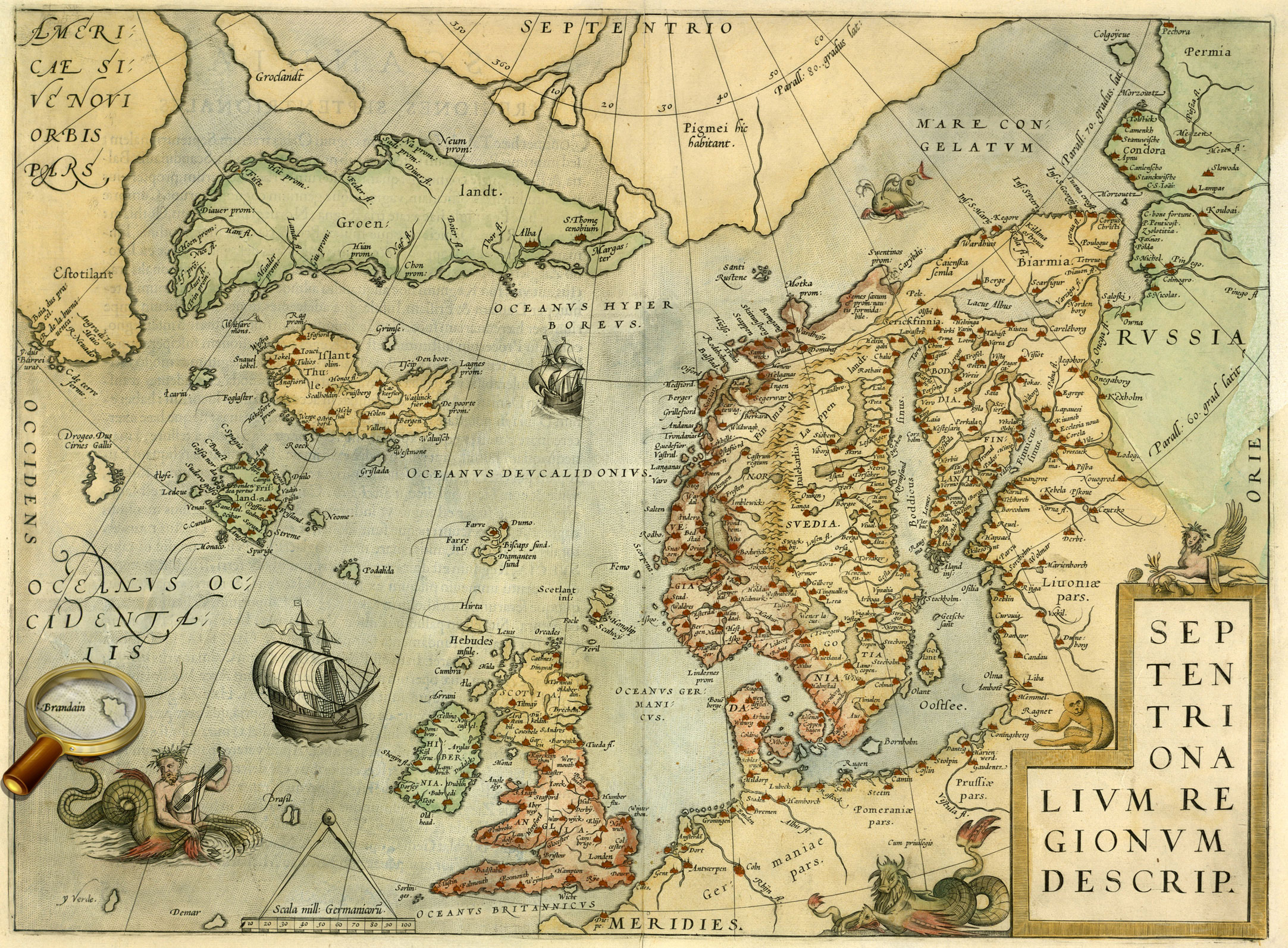
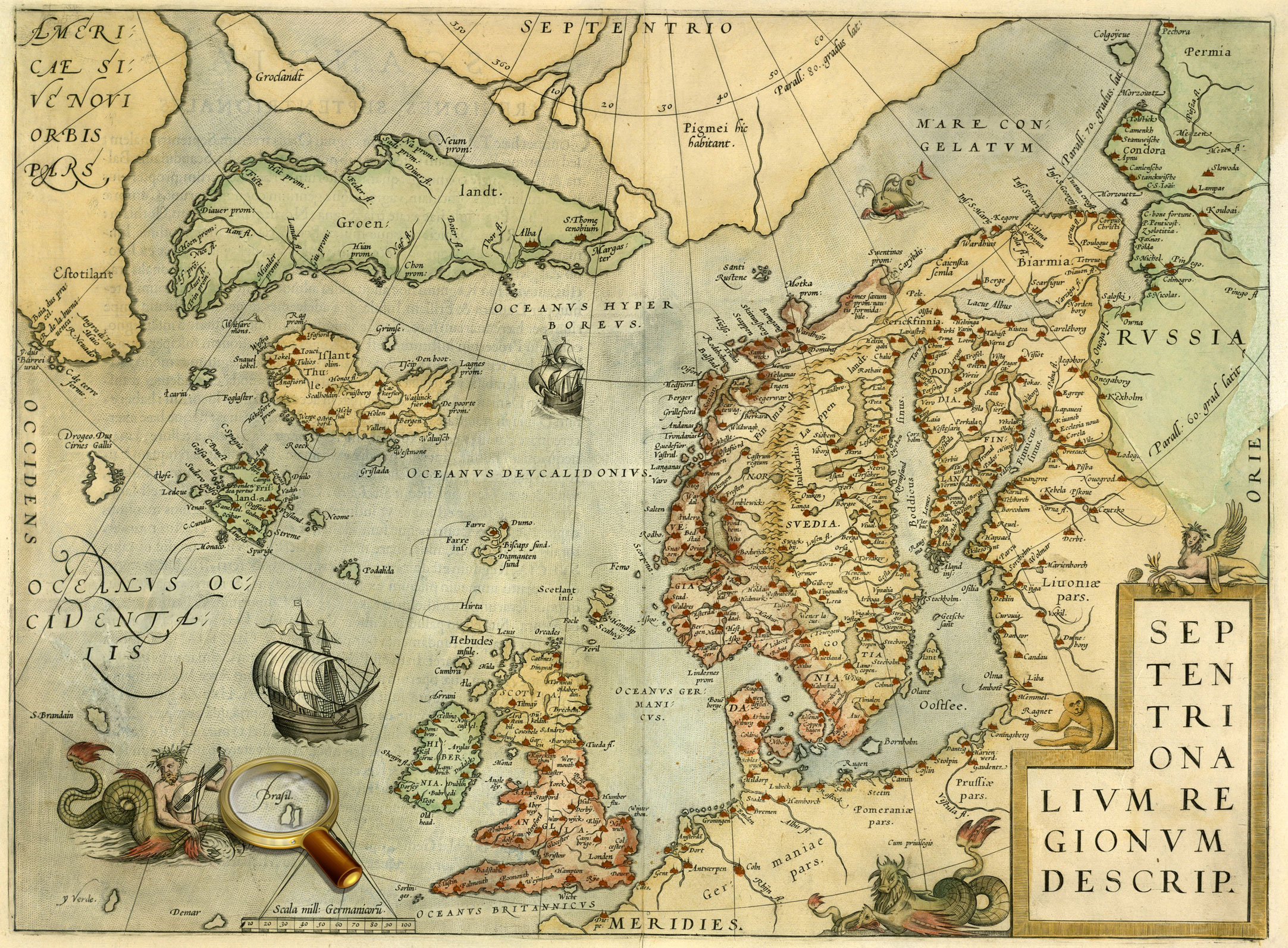
Frisland Insula is a phantom island shown on the maps of the North Atlantic from the 1560s to the 1660s .
Cartographers placed Frisland to the south of Iceland at the same longitude. It is now believed that its appearance on the maps of 1560s and after was just a result of an error: perhaps, map-makers incorrectly identified the location of one of the Faroe Islands. However, Frisland and the Faroe Islands are both depicted on the same maps but the latter are further east. In form, none of the Faroe Islands does not resemble the outlines of Frisland.
Island of St. Brendan
Saint Brendan’s Isle is a mythical island, supposedly located in the Atlantic. This rocky island, described by many travelers in the Middle Ages, was first mentioned starting with the 9th century.
It is best known for "Voyage of Saint Brendan the Navigator" which describes traveling of the Catholic monk St. Brendan from Ireland to the west across the Atlantic Ocean.
The Island of St. Brendan is believed to be the eighth island of the Canary archipelago, not-existed in reality, or the Island of the Blessed, and the earthly Paradise. After the discovery of America by Columbus, attempts were made to identify the Island of Saint Brendan with it and to attribute to St. Brendan the honor of the discovery of America.
Brasil
Brasil, also known as Hy-Brasil, is the Island of the Blessed in the Atlantic Ocean. The mythical Brasil island as shown in relation to Ireland on a map by Abraham Ortelius (1572) Brasil
It was appeared on maps in the early Middle Ages, many maps of the 14th-17th centuries show it.
It was said about Brasil that it was surrounded by mist and fog that cleared away once in seven years. Then only the island can be seen. Monks and other people who lived on it, never had any troubles.
Because of lack of accurate information regarding the location of the island, cartographers constantly "moved" the island on the map. Most often they placed Brazil to the west of Ireland, but sometimes it was "shifted" in the area of the Azores.
Thule
Thule (Tile) is a legendary island in the North Europe, described by the ancient Greek explorer Pytheas (approx. 380 - 310 BC) in his work «On the Ocean».
In the Middle Ages, Thule often was identified with Iceland, the Faroe, Shetland or Orkney Islands, the Hebrides, sometimes it was even regarded as part of the Britain, Scandinavia, Jutland. However, some of the ancient authors express doubts about the existence of this island.
Magnetic Islands
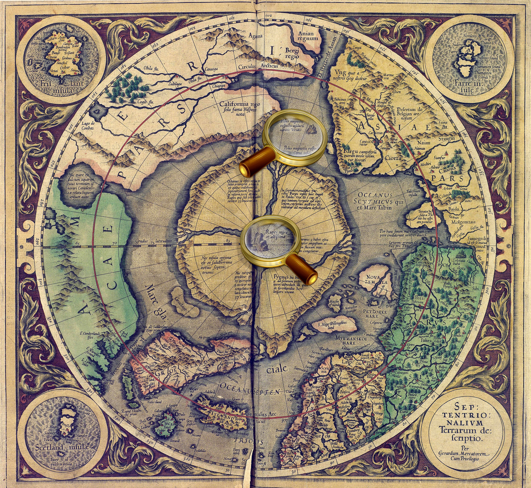
Magnetic Islands (Polus magnetis) are fabulous lands, where according to the ideas of that time, was the Earth's magnetic pole.
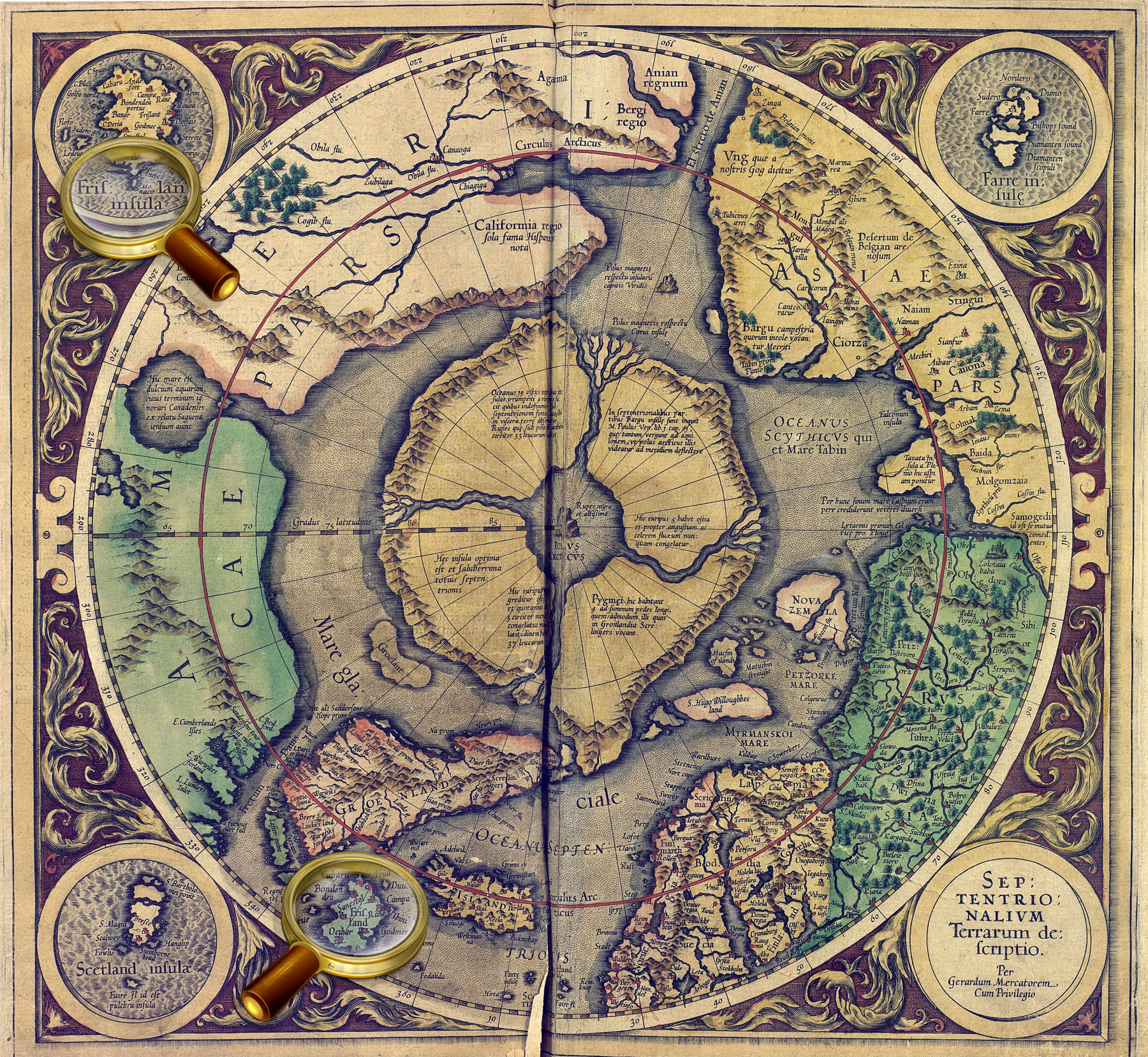
In the center of the map, there was displayed the Black Rock (Rupes Nigra) located at the North Pole and having magnetic properties. Based on his studies of the magnetic poles and the researches of other scientists, Gerardus Mercator mapped two islands indicated as magnetic: rocky one and a very small isle shown as a circle.
Sannikov Land
Sannikov Land is a phantom island in the Arctic Ocean, which was allegedly seen by some researchers to the north of the New Siberian Islands.
The merchant and hunter for polar foxes Yakov Sannikov (1749-1845) was the first to inform about it in 1810. He was not only a fossil ivory tusk dealer. The experienced arctic explorer Sannikov discovered two islands in the New Siberian archipelago: Stolbovoy and Faddeyevsky. He suggested the existence of a vast land north of the Kotelny Island.
Another evidence of the existence of vast lands in the north was given via numerous observations of migratory birds such as polar geese flying further to the north in spring , and returning with the breed in autumn. Since birds can not live in the icy wilderness, it was suggested that Sannikov Land was relatively warm and fertile, and the birds flied to this very place. However, the obvious question is: how the fertile land may be located to north of the desert coast of Eurasia? Due to the considerable difficulties and lack of proper equipment, the expeditions who studied this region in the 19th century, did not finally confirmed or refuted the existence of Sannikov Land.
It was only in 1937, the Soviet icebreaker "Sadko", during his drift motion, went near the hypothetical island from the south, from the east and from the north - but nothing but ocean ice was not found. Planes of Arctic aviation were sent to the same area. And, despite all efforts, these searches were negative: it was established that Sannikov Land did not exist. Some geographers believe that Sannikov Land like many other Arctic islands, including the most ones within the New Siberian archipelago, was formed of fossilized ice (of permafrost), over which surface soil drifted. Over time, the ice melted, and Sannikov Land disappeared. The researchers found only a shallow sand shoal at its mapped location, which they called the Sannikov shoal. The riddle of polar geese also was recently cleared up – it turned out that they fly to Canada and Alaska having so strange route.
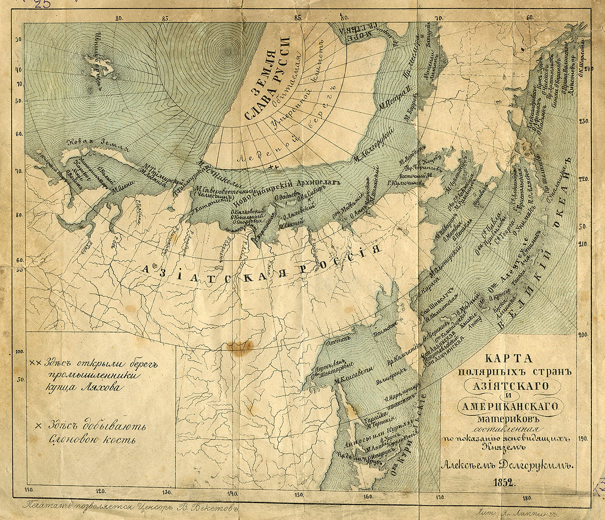
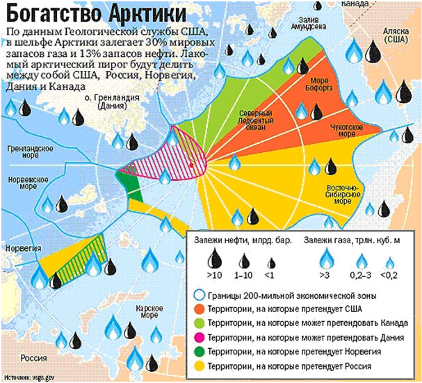
Land of Glory to Russia
Land of Glory of Russia is a large inhabited area, shown in Arctic waters on the «Map of the polar regions of the Asian and American continents». It is noteworthy that the location of the mythical land roughly coincides with the modern areas with potential for mineral deposits.
The map was produced by Aleksey Dolgoruky (1813 -1869?), a retired lieutenant and an author of books on his family history and on hypnosis. One of his books contains the map of the northern, polar regions, compiled according to the legends of clairvoyants.
Since 1840, Aleksey Dolgoruky treated patients by hypnosis in Moscow institutions, since 1859, he was officially appointed to serve at St. Petersburg hospitals of Empress Maria for the treatment by hypnosis.
Maria-Theresa Reef
Maria-Theresa Reef (also known as Tabor Island) was supposed to be situated east of New Zealand and south of French Tuamotu islands. The island was discovered by the whaleman Asaph P. Taber in 1843 and was named after the American town of Maria Teresa, where he was born. According to another version, the name was given in honor of the ship.
One of the many non-existent reefs in the South Pacific was shown on the maps until the second half of the 20th century.
Jules Verne's novels «The Children of Captain Grant» and «The Mysterious Island» brough fame to the reef. On this island, Captain Grant found refuge after the shipwreck. Ayrton was left there, and from there he was taken by inhabitants of Lincoln Island. Contrary to popular opinion, Maria-Theresa Reef is not a result of author's fantasy unlike Lincoln Island; Jules Verne sincerely, like his contemporaries, believed that the island existed.
Septentrionalium Terrarum descriptio. From the atlas: Atlas sive Cosmographicæ Meditationes…Duisburg, 1595. P. 1.
Map of the North Pole from the world atlas of Gerardus Mercator "Atlas or cosmographical meditations upon the creation of the universe, and the universe as created", Duisburg, 1595.
One of the four polar islands has an inscription, 'It is home to the pygmies' that some sources interpreted as an indication of the legendary Hyperborea. K 0-Mir 7/10 Veiw in the Digital Library
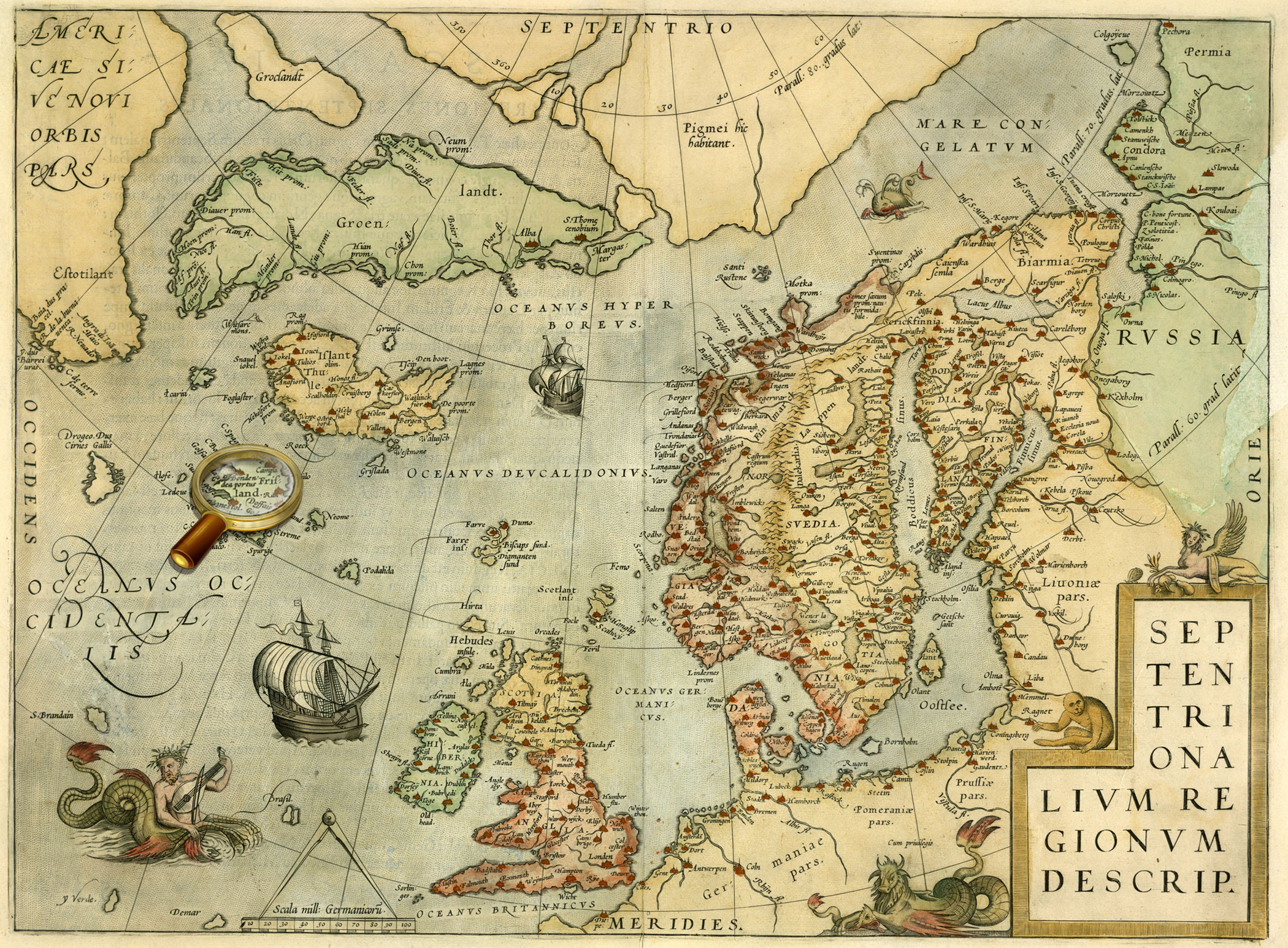
Septentrionalium regionum descrip. From the atlas: Theatrum orbis terrarum. Antverpen, 1570. P. 45.
Map of the Scandinavia from Abraham Ortelius' atlas «Theatre of the World», published in Antwerp in 1570.
One of the four polar islands has an inscription, 'It is home to the pygmies' that some sources interpreted as an indication of the legendary Hyperborea. К 0-Мир 7/11 Veiw in the Digital Library
Quivirae regnum, cum aliis versus Boream. Novae Gvineae Forma & Situs. From the atlas: Speculum orbis terrӕ. Antverpea, 1593-1613. P. 12.
Maps of part of North America (Quivira) and New Guinea from the world atlas Gerard de Jode «Mirror of the World». Antwerp, 1593-1613. P.12.
The map of Quivira contains a text in which residents of the area are compared with the Tatars – a reference to the theory that North America was part of Asia and was populated by immigrants from Asia.
К 0-Мир 7/9 Veiw in the Digital Library
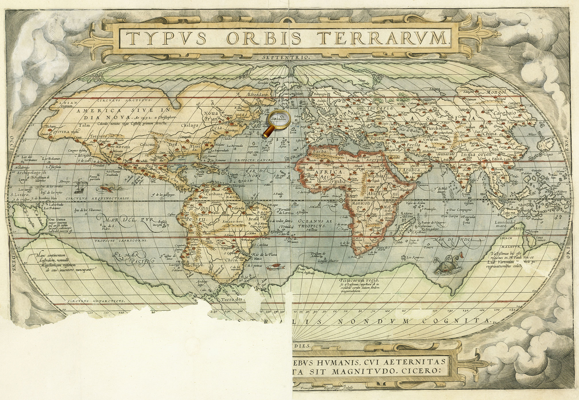
Typus orbis terrarum. From the atlas: Theatrum orbis terrarum. Antverpen, 1570. P. 1.
World map from Abraham Ortelius' atlas «Theatre of the World», published in Antwerp in 1570
К 0-Мир 7/11 Veiw in the Digital Library
Orbis terrae compendiosa descriptio. From the atlas: Atlas sive Cosmographicæ Meditationes…Duisburg, 1595. [P. 1].
World map from the world atlas of Gerardus Mercator "Atlas or cosmographical meditations upon the creation of the universe, and the universe as created", Duisburg, 1595.
К 0-Мир 7/10 Veiw in the Digital Library
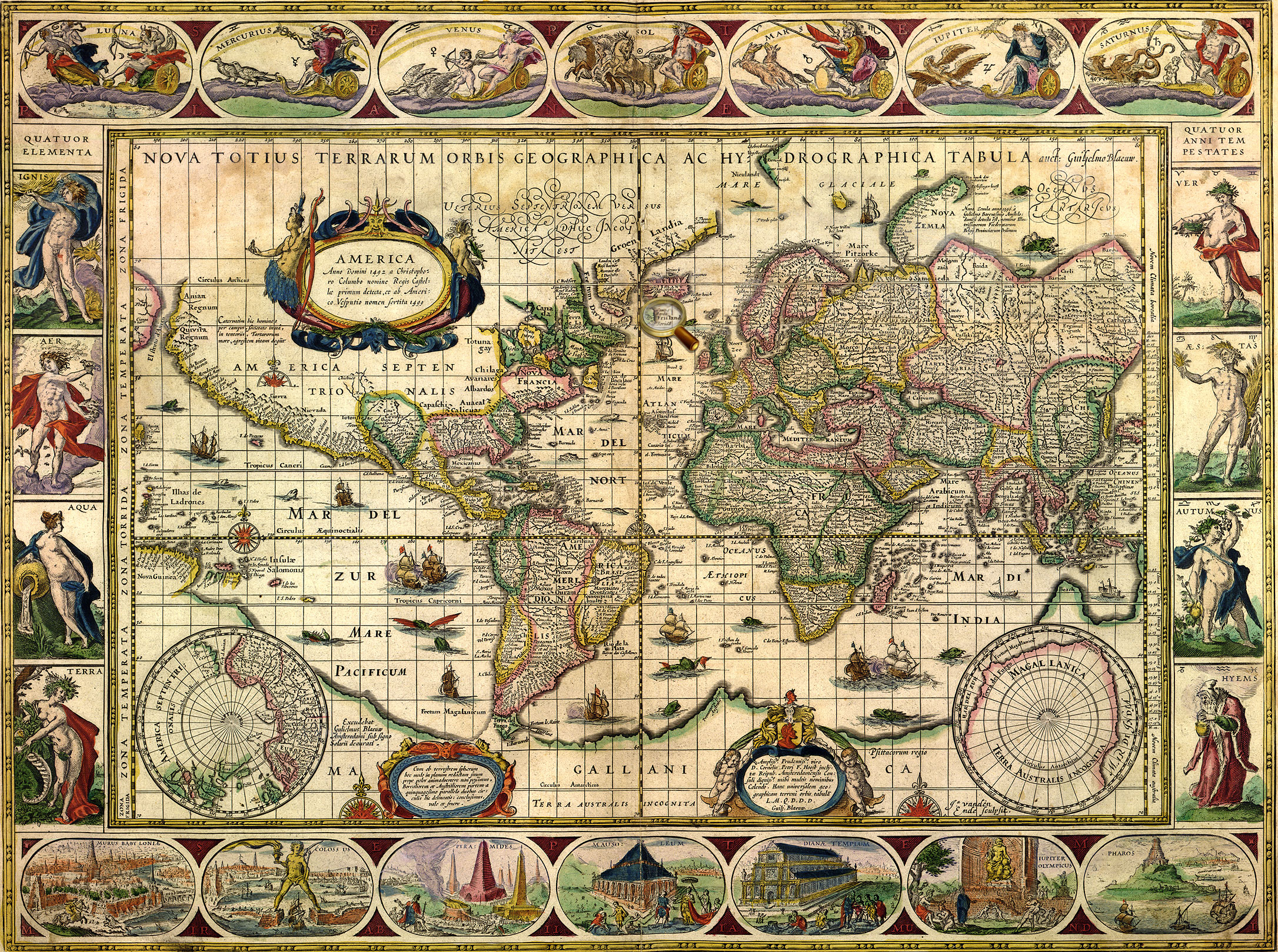
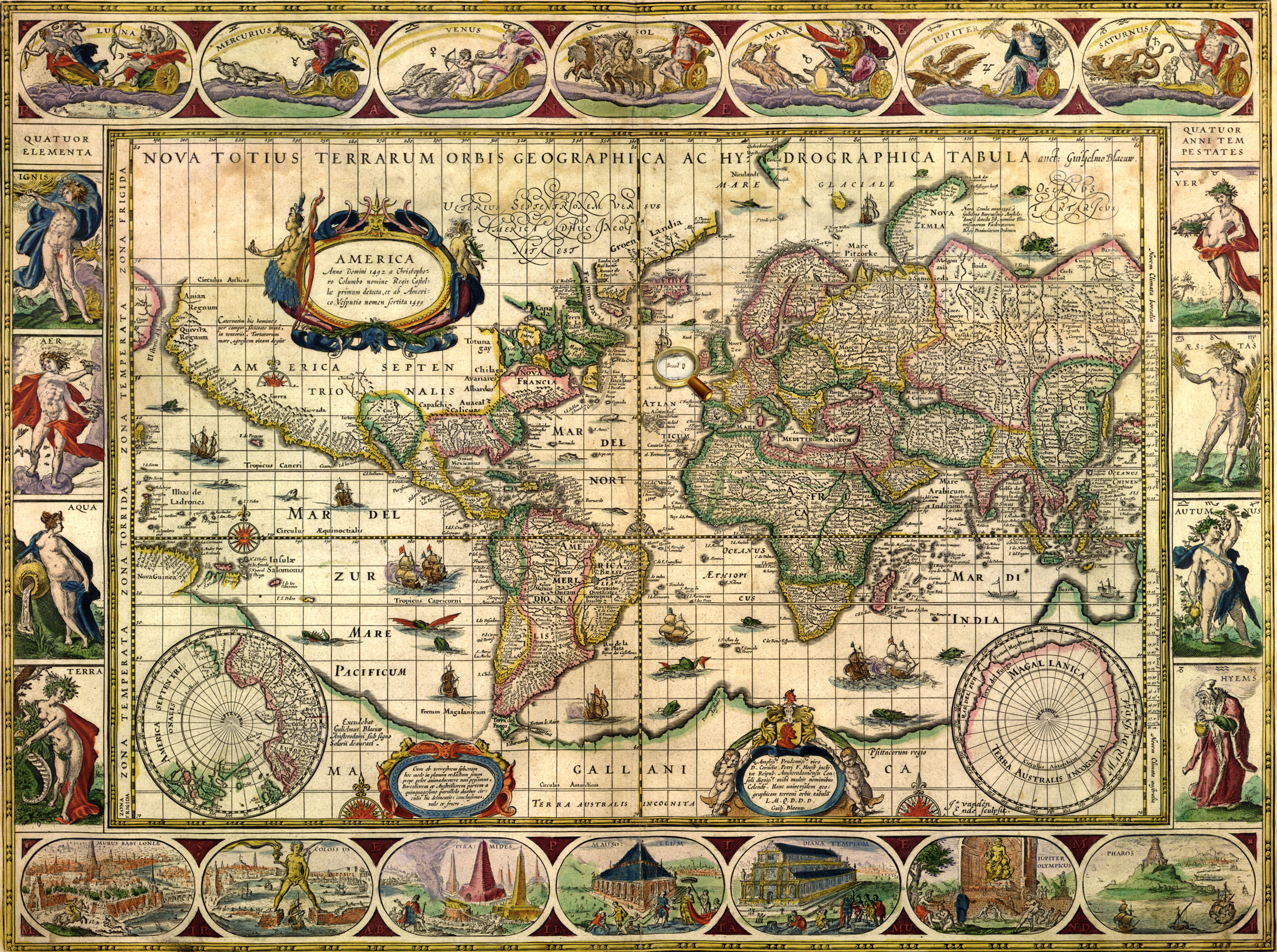
Nova totius terrarum orbis geographica ac hydrographica tabula. Auct. Guilj. Blaeuw. From the atlas: Theatrum orbis terrarum, Sive Atlas novus …Vol. 1. Amsterdam: J. G. Blaeu, 1645.
World map from Vol.1 of Joan Blaeu's atlas, published in Amsterdam in 1645 К 0-Мир 8/112_1 Veiw in the Digital Library
L’ Amerique Septentrionale Suivant les Nouvelles observations de mess-rs de l’ Academie Royale des Sciences etc, augmentees de nouveau. Avec privil.. - Leide : chez Pierre van der Aa, 16…?].
Map of North America. К 0-САм 1/3 Veiw in the Digital Library
Americae Pars Borealis, Florida, Baccalaos, Canada, Corterealis…From the atlas: Speculum orbis terrӕ. Antverpiae, 1593-1613. P. 11.
Map of part of North America from the world atlas Gerard de Jode «Mirror of the World». Antwerp, 1593-1613. P.11. К 0-Мир 7/9 Veiw in the Digital Library
Orbis terrae compendiosa descriptio. From the atlas: Atlas sive Cosmographicæ Meditationes…Duisburg, 1595. [P. 1].
World map from the world atlas of Gerardus Mercator "Atlas or cosmographical meditations upon the creation of the universe, and the universe as created", Duisburg, 1595.
К 0-Мир 7/10 Veiw in the Digital Library
L’ Amerique Septentrionale. M. Ogier fecit.. - S.l., [late 17th cent.]. Map of North America. К 0-САм 1/4 Veiw in the Digital Library
L’ Amerique Septentrionale Suivant les Nouvelles observations de mess-rs de l’ Academie Royale des Sciences etc, augmentees de nouveau. Avec privil.. - Leide : chez Pierre van der Aa, 16…?].
Map of North America. К 0-САм 1/3 Veiw in the Digital Library
Americae Pars Borealis, Florida, Baccalaos, Canada, Corterealis…From the atlas: Speculum orbis terrӕ. Antverpiae, 1593-1613. P. 12. Map of part of North America from the world atlas Gerard de Jode «Mirror of the World». Antwerp, 1593-1613. P. 11. К 0-Мир 7/9 Veiw in the Digital Library
Orbis terrae compendiosa descriptio. From the atlas: Atlas sive Cosmographicæ Meditationes…Duisburg, 1595. [P. 1].
World map from the world atlas of Gerardus Mercator "Atlas or cosmographical meditations upon the creation of the universe, and the universe as created", Duisburg, 1595.
К 0-Мир 7/10 Veiw in the Digital Library
Americae nova tabula. Auct. Guiljelmo Blaeuw. From the atlas: Theatrum Orbis Terrarum, sive Atlas Novus. Vol. 2. Amsterdam : Apud Iohanem Guiljelmi F. Blaeu, 1645. Map of North and South America from Vol. 2 of Joan Blaeu's atlas, published in Amsterdam in 1645 К 0-Мир 8/112_2 Veiw in the Digital Library
Americaу Pars Meridionalis. – Amstelodami: J. Janssoniy, [after 1630 Map of South America From Johannes Janssonius' atlas, published in Amsterdam in 1630. On the shore of Lakes Parime, there is an inscription "Manoa, or El Dorado. К 0-ЮАм 2/21 Veiw in the Digital Library
Americae nova tabula. Auct. Guiljelmo Blaeuw. From the atlas: Theatrum Orbis Terrarum, sive Atlas Novus. Vol. 2. Amsterdam: J/ G. Blaeu, 1645.
Map of North and South America from Vol. 2 of Joan Blaeu's atlas, published in Amsterdam in 1645 К 0-Мир 8/112_2 Veiw in the Digital Library
Le Perou et le cours de la Riv.re Amazone. Par N.Sanson d’Abbeville Geographe ord.-re du Roy. [Paris, 1683].
On the shore of Lake Parime (Parime) is an inscription «Manoa, or Eldorado». К 0-ЮАм 1/3 Veiw in the Digital Library
America Meridionalis Concinnata juxta Observayiones… Per G. de l'Isle. Augustæ Vindel, Vol. C. Lotter, [1770].
Map of South America, compiled by G. Delisle in 1700, and reprinted by the Lotter publishing house after 1760 The legendary country Eldorado is marked on the area called Terra Firma («mainland province» of Spain in contrast to the neighboring island colonies of Spain), present-day part of Venezuela and Colombia. К 1-ЮАм 2/27 Veiw in the Digital Library
[Madagascar, North-East Africa, Red Sea, Arabia] from the facsimile of the Atlas Universal. Diogo Homem, [1565. Barselona, 2000. Map of 8.]
The map shows the east coast of Africa. A figure of the Christian king [Prester John], often shown on the maps of the 15th-16th centuries, is placed in the center, in what is now Ethiopia. К 4-Мир 28/3794
Russia cum confinÿs. Per Gerardum Mercatorem. Cum privilegio. [Amsterdam, 1633].
Map of Russia from the atlas of G. Mercator – J. Hondius, Amsterdam, 1633.
One of the earliest map Russia, created by foreign cartographers. On the territory of the Asian part of Russia, there is depicted Lucomoria.
К 0-МоскЕ 2/19 Veiw in the Digital Library
Novissima Russiae Tabula….. Authore Isaaco Massa. Amstelodami, Hen. Hondius, sumptibus Joannis Janssonii. - Amstelodami : Hen. Hondius, sumptibus Joannis Janssonii, [1644]
Map of Russia From the atlas мира J. Hondius- J.Janssonius, Amsterdam, 1644.
One of the earliest map Russia, created by foreign cartographers. On the territory of the Asian part of Russia, there is depicted Lucomoria. К 0-МоскЕ 2/40 Veiw in the Digital Library
La Russie Blanche ou Moscovie Divisée suivant l’Etendu des Royaumes, Duchés, Principautés etc. Presenté à Monseigneur le Duc de Bourgogne par… H.Jaillot. - Paris, 1695.
One of the earliest map Russia, created by foreign cartographers. On the territory of the Asian part of Russia, there is depicted Lucomoria. К 0-МоскЕ 2/50 Veiw in the Digital Library
Carte Tartarie. Dressée sur les Relations de plusieurs Voyageurs de differentes Nations et sur quelques observations qui ont été faites dans ce pais là Par Guillaume de l'Isle Avec Privil. Amsterdam, chez J. Covens et C. Mortier [1720?].
Map of Tartary, compiled by G. Delisle using materials of many travelers, and published in Amsterdamе in ca. 1720. In the northern part of the map , there is an inscription «Lukomoria».
Septentrionalium Terrarum descriptio. From the atlas: Atlas sive Cosmographicæ Meditationes…Duisburg, 1595. P. 1. Map of Noth Pole from the world atlas of Gerardus Mercator "Atlas or cosmographical meditations upon the creation of the universe, and the universe as created", Duisburg, 1595.
Island Friesland is shown on the map at the bottom, on the left of Iceland, and is given an supplementary map on the top left. К 0-Мир 7/10 Veiw in the Digital Library
Typus orbis terrarum. From the atlas: Theatrum orbis terrarum. Antverpen, 1570. P. 1.
World map from Abraham Ortelius' atlas «Theatre of the World», Antwerp, 1570. К 0-Мир 7/11 Veiw in the Digital Library
Septentrionalium regionum descrip. From the atlas: Theatrum orbis terrarum. Antverpen, 1570. P. 45.
Map of Scandinavia from Abraham Ortelius' atlas «Theatre of the World», Antwerp, 1570. К 0-Мир 7/11 Veiw in the Digital Library
Nova totius terrarum orbis geographica ac hydrographica tabula. Auct. Guiljelmo Blaeuw. From the atlas: Theatrum orbis terrarum, Sive Atlas novus …Vol. 1. Amsterdam: J. G. Blaeu, 1645.
World map from Vol.1 of Joan Blaeu's atlas, published in Amsterdam in 1645 К 0-Мир 8/112_1 Veiw in the Digital Library
Typus orbis terrarum. From the atlas: Theatrum orbis terrarum. Antverpen, 1570. P. 1.
World map from Abraham Ortelius' atlas «Theatre of the World», Antwerp, 1570. К 0-Мир 7/11 Veiw in the Digital Library
Septentrionalium regionum descrip. From the atlas: Theatrum orbis terrarum. Antverpen, 1570. P. 45.
Map of Scandinavia from Abraham Ortelius' atlas «Theatre of the World», Antwerp, 1570. К 0-Мир 7/11 Veiw in the Digital Library
Septentrionalium regionum descrip. From the atlas: Theatrum orbis terrarum. Antverpen, 1570. P. 45.
Map of Scandinavia from Abraham Ortelius' atlas «Theatre of the World», Antwerp, 1570. Replica. К 0-Мир 7/11 Veiw in the Digital Library
Nova totius terrarum orbis geographica ac hydrographica tabula. Auct. Guiljelmo Blaeuw. From the atlas: Theatrum orbis terrarum, Sive Atlas novus …Vol. 1. Amsterdam: J. G. Blaeu, 1645.
World map from Vol.1 of Joan Blaeu's atlas, published in Amsterdam in 1645 К 0-Мир 8/112_1 Veiw in the Digital Library
[Carta marine… Anno 1539,… Olaus Magnus…] Romæ, Antony Lafrery, 1572.
Replica. «Carta Marina» is one of the earliest and most reliable historical maps of North Europe, created by the Swedish church figure, diplomat and writer Olaus Magnus. He used as personal travel notes, cards Scandinavian sailors and maps from Ptolemy's Geography as the sources for the map. Besides a detailed picture of geographic features, the map contains more than 100 miniatures depicting real and imaginary animals, local customs and costumes, historical events, and fabulous lands, including - the island Thule (Tile). К 0-Ск 3/36 Veiw in the Digital Library
Septentrionalium regionum descrip. From the atlas: Theatrum orbis terrarum. Antverpen, 1570. P. 45.
Map of Scandinavia from Abraham Ortelius' atlas «Theatre of the World», Antwerp, 1570. К 0-Мир 7/11 Veiw in the Digital Library
Septentrionalium Terrarum descriptio. From the atlas: Atlas sive Cosmographicæ Meditationes…Duisburg, 1595. P. 1. Map of North Pole from the world atlas of Gerardus Mercator "Atlas or cosmographical meditations upon the creation of the universe, and the universe as created", Duisburg, 1595.
In the center of the map, there was dipicted the Black Rock (Rupes Nigra) located at the North Pole and having magnetic properties, according to Mercator, which has magnetic properties. In addition, based on his studies of the magnetic poles and the researches of other scientists, Gerardus Mercator mapped two islands indicated as magnetic: rocky one and a very small isle shown as a circle. К 0-Мир 7/10 Veiw in the Digital Library
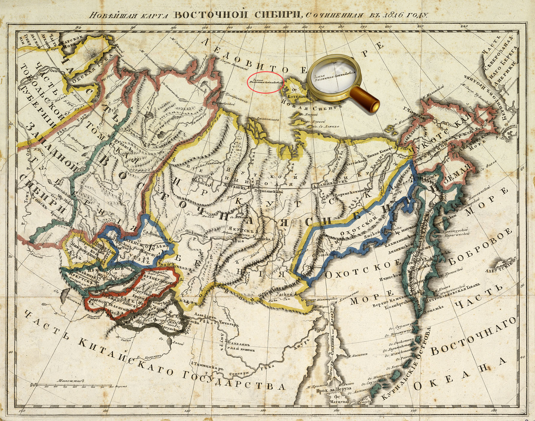
The latest map of Eastern Siberia, compiled in 1816. [Without place], 1816.
On the map, in the Arctic Ocean, there is an inscription, 'Land seen by Sannikov' К 2-Сиб 1/12 Veiw in the Digital Library
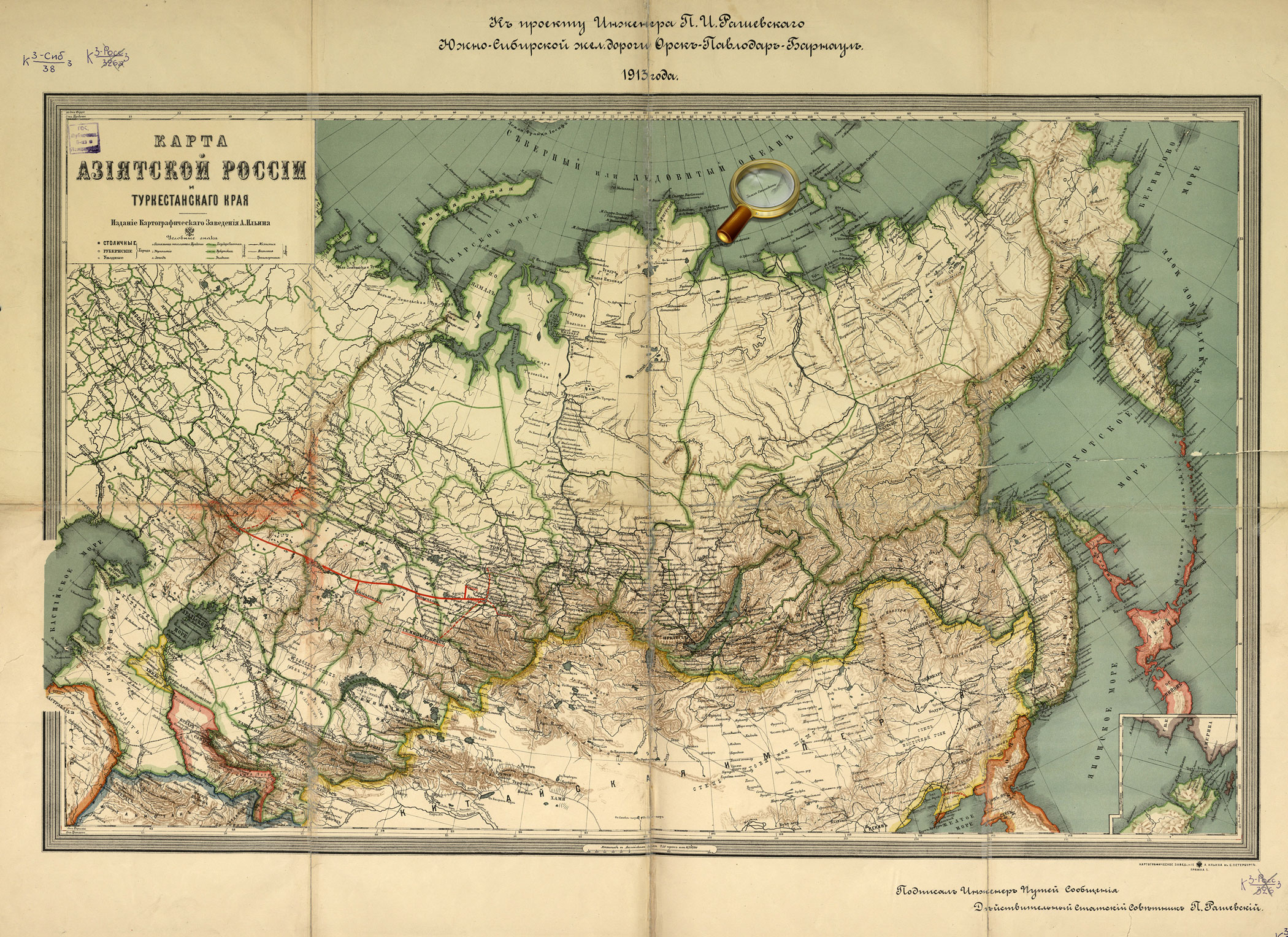
Map of Asiatic part of Russia and Turkestan region. To the project of the South-Siberian Railroad Orsk-Pavlodar-Barnaul by the engineer P.I. Rashevsky, dated to 1913. [Without place], 1913. The map shows Sannikov Land in the Arctic Ocean. К 3-Сиб 3/38 Veiw in the Digital Library
Map of polar regions of the Asian and American continents. Compiled by Prince Alexey Dolgoruky according to the testimony of clairvoyants. [St. Petersburg], Lithography of J. Lapping, 1852. К 3-Арк 1/25 Veiw in the Digital Library
Illustration to the article: B.S. Lukshin. Arctic knot of military-political relations between US and Russia /
Pacific Ocean. South part. From the atlas: Marine Atlas. Editor-in-chief Professor Fleet Admiral I.S. Isakov. Vol.1. Navigational and Geographical. [P.6 ], Naval General Staff, 1950-1963. The map shows Reef Maria Teresa in the Pacific Ocean. К 4-Мир 8/796
Octava Europe Tabula. From the atlas: [Collection of maps of Claudius Ptolemy. Rome, 1508. Map 8.].
Eight map of Europe [Collection of maps of Claudius Ptolemy. Rome, 1508].
The map shows the area between the Baltic Sea (with parts of Scandinavia) and the Black Sea (with the Crimean peninsula). The legendary Riphean Mountains are shown on the territory of the European Sarmatia. К 0-Мир 7/345 Veiw in the Digital Library
America Pars Meridionalis. – Amstelodami: J. Janssoniy, [after 1630].
Map of South America, compiled for Johannes Janssonius' atlas published in Amsterdam in 1630.
К 0-ЮАм 2/21 Veiw in the Digital Library
Americae nova tabula. Auct. Guiljelmo Blaeuw. From the atlas: Theatrum Orbis Terrarum, sive Atlas Novus. Vol. 2. Amsterdam : Apud Iohanem Guiljelmi F. Blaeu, 1645-1650.
Map of North and South America from Vol.2 Willem Blaeu's atlas. К 0-Мир 8/112_2 Veiw in the Digital Library
Typus orbis terrarum. From the atlas: Theatrum orbis terrarum. Antverpen, 1570. P. 1.
World map from Abraham Ortelius' atlas «Theatre of the World», Antwerp, 1570. «Terra Australis Nondum Cognita» is shown at the bottom of the map.
К 0-Мир 7/11 Veiw in the Digital Library
Orbis terrae compendiosa descriptio. From the atlas: Atlas sive Cosmographicæ Meditationes…Duisburg, 1595. [P. 1].
World map from the world atlas of Gerardus Mercator "Atlas or cosmographical meditations upon the creation of the universe, and the universe as created", Duisburg, 1595.
«Terra Australis» is shown at the bottom of the map. К 0-Мир 7/10 Veiw in the Digital Library
Nova totius terrarum orbis geographica ac hydrographica tabula. Auct. Guiljelmo Blaeuw. From the atlas: Theatrum orbis terrarum, Sive Atlas novus …Vol. 1. Amsterdam: J. G. Blaeu, 1645.
World map from Vol.1 of Joan Blaeu's atlas, published in Amsterdam in 1645
«Magallanica. Terra Australis Incognita» is shown at the bottom of the map and on the right of the supplementary map. К 0-Мир 8/112_1 Veiw in the Digital Library
Tartariae sive magni chami regni. From the atlas: Theatrum orbis terrarum. Antverpen, 1570. [P. 47]
Map of Tartary or the Kingdom of Great Ham from Abraham Ortelius' atlas «Theatre of the World», Antwerp, 1570.
The map shows the north-eastern part of Asia and the north-western part of America, separated by the Strait Aniane.
К 0-Мир 7/11 Veiw in the Digital Library
Quivirae regnum cum aliis versus Boream. Nоvae Gvineae Forma & Situs. From the atlas: Speculum orbis terrӕ. Antverpen, 1593-1613. P. 12.
Maps of part of North America (Quivira) and New Guinea from the world atlas Gerard de Jode «Mirror of the World». Antwerp, 1593-1613. P. 12.
К 0-Мир 7/9 Veiw in the Digital Library
Orbis terrae compendiosa descriptio. From the atlas: Atlas sive Cosmographicæ Meditationes…Duisburg, 1595. [P. 1].
World map from the world atlas of Gerardus Mercator "Atlas or cosmographical meditations upon the creation of the universe, and the universe as created", Duisburg, 1595.
К 0-Мир 7/10 Veiw in the Digital Library
Nova totius terrarum orbis geographica ac hydrographica tabula. Auct. Guiljelmo Blaeuw. From the atlas: Theatrum orbis terrarum, Sive Atlas novus …Vol. 1. Amsterdam: J. G. Blaeu, 1645.
World map from Vol.1 of Joan Blaeu's atlas, published in Amsterdam in 1645 К 0-Мир 8/112_1 Veiw in the Digital Library


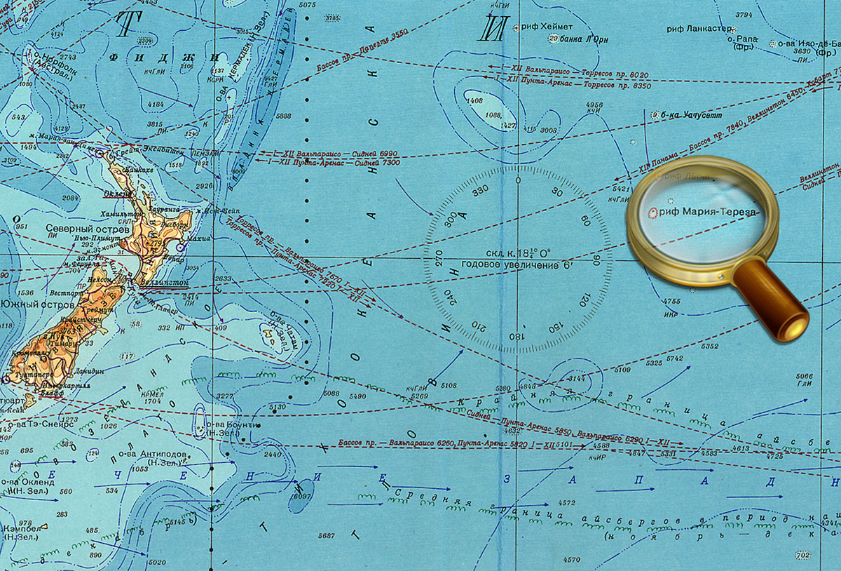 Maria-Theresa Reef (also known as Tabor Island) was supposed to be situated east of New Zealand and south of French Tuamotu islands. The island was discovered by the whaleman Asaph P. Taber in 1843 and was named after the American town of Maria Teresa, where he was born. According to another version, the name was given in honor of the ship.