Non-existent Mountains and Lakes
- Non-existent Mountains and Lakes
- Confirmed Assumptions
Riphean Mountains
 The Riphean Mountains are mountains giving rise to the main rivers of Scythia: the Don and the Volga. Ancient greeks placed the Riphean mountains on the border of Scythia and Hyperborea, where was the home of the North Wind Boreas.
In the II century AD, Claudius Ptolemy summarized historical and geographical facts known in his time, which then were used by many medieval map-makers.
Various scientific writers applied the term to the Ural Mountains, the Caucasus, the Central Asian mountains (Tien Shan) and so forth.
Lake Parime
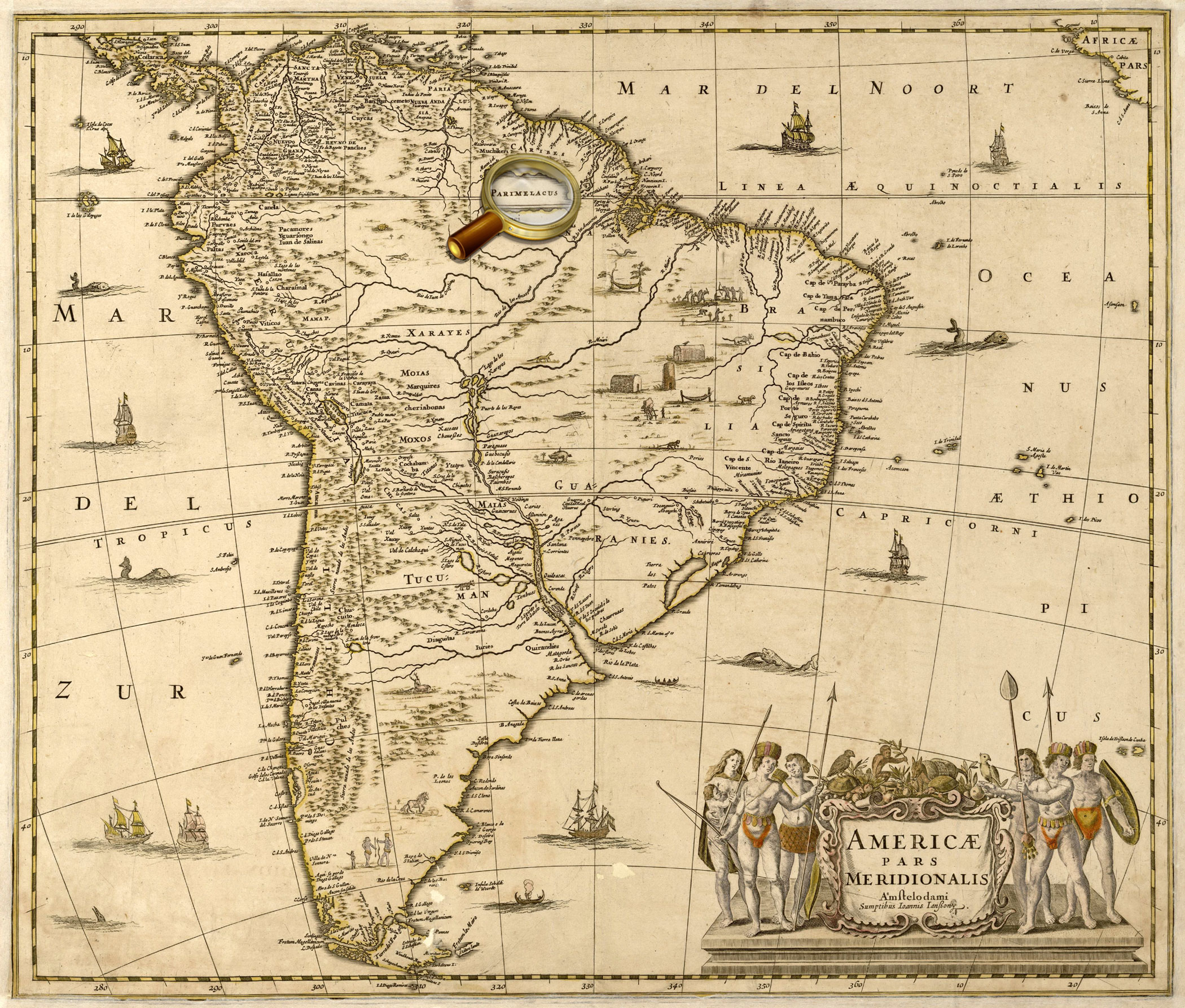
The Parime had been shown on maps up to the early 19th century when Alexander von Humboldt (1769-1859), during his expedition of 1799-1804, proved that there were no lakes in the Orinoco basin, and rumors about its existence could be generated by extensive flooding of the rivers.
Map of the North Pole from the world atlas of Gerardus Mercator "Atlas or cosmographical meditations upon the creation of the universe, and the universe as created", Duisburg, 1595.
One of the four polar islands has an inscription, 'It is home to the pygmies' that some sources interpreted as an indication of the legendary Hyperborea.
K 0-Mir 7/10
Veiw in the Digital Library
Map of the Scandinavia from Abraham Ortelius' atlas «Theatre of the World», published in Antwerp in 1570.
One of the four polar islands has an inscription, 'It is home to the pygmies' that some sources interpreted as an indication of the legendary Hyperborea.
К 0-Мир 7/11
Veiw in the Digital Library
Maps of part of North America (Quivira) and New Guinea from the world atlas Gerard de Jode «Mirror of the World». Antwerp, 1593-1613. P.12.
The map of Quivira contains a text in which residents of the area are compared with the Tatars – a reference to the theory that North America was part of Asia and was populated by immigrants from Asia.
К 0-Мир 7/9
Veiw in the Digital Library
World map from Abraham Ortelius' atlas «Theatre of the World», published in Antwerp in 1570
К 0-Мир 7/11
Veiw in the Digital Library
World map from the world atlas of Gerardus Mercator "Atlas or cosmographical meditations upon the creation of the universe, and the universe as created", Duisburg, 1595.
К 0-Мир 7/10
Veiw in the Digital Library
From the atlas: Theatrum orbis terrarum, Sive Atlas novus …Vol. 1. Amsterdam: J. G. Blaeu, 1645.
World map from Vol.1 of Joan Blaeu's atlas, published in Amsterdam in 1645
К 0-Мир 8/112_1
Veiw in the Digital Library
Map of North America.
К 0-САм 1/3
Veiw in the Digital Library
Map of part of North America from the world atlas Gerard de Jode «Mirror of the World». Antwerp, 1593-1613. P.11.
К 0-Мир 7/9
Veiw in the Digital Library
World map from the world atlas of Gerardus Mercator "Atlas or cosmographical meditations upon the creation of the universe, and the universe as created", Duisburg, 1595.
К 0-Мир 7/10
Veiw in the Digital Library
К 0-САм 1/4
Veiw in the Digital Library
Map of North America.
К 0-САм 1/3
Veiw in the Digital Library
Map of part of North America from the world atlas Gerard de Jode «Mirror of the World». Antwerp, 1593-1613. P. 11.
К 0-Мир 7/9
Veiw in the Digital Library
World map from the world atlas of Gerardus Mercator "Atlas or cosmographical meditations upon the creation of the universe, and the universe as created", Duisburg, 1595.
К 0-Мир 7/10
Veiw in the Digital Library
Vol. 2. Amsterdam : Apud Iohanem Guiljelmi F. Blaeu, 1645.
Map of North and South America from Vol. 2 of Joan Blaeu's atlas, published in Amsterdam in 1645
К 0-Мир 8/112_2
Veiw in the Digital Library
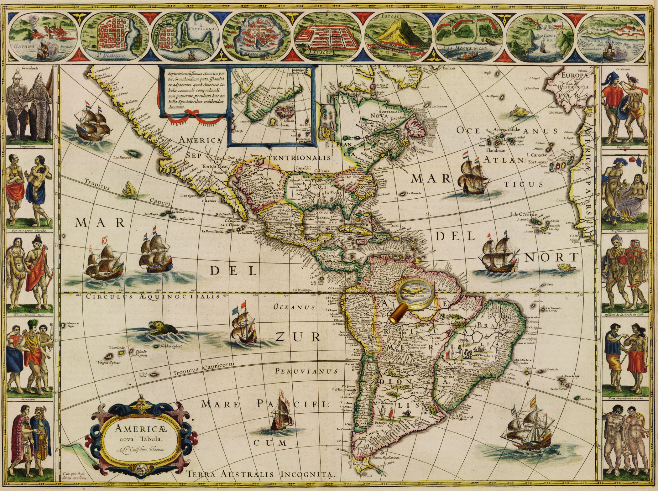
From Johannes Janssonius' atlas, published in Amsterdam in 1630.
On the shore of Lakes Parime, there is an inscription "Manoa, or El Dorado.
К 0-ЮАм 2/21
Veiw in the Digital Library
From the atlas: Theatrum Orbis Terrarum, sive Atlas Novus. Vol. 2. Amsterdam: J/ G. Blaeu, 1645.
Map of North and South America from Vol. 2 of Joan Blaeu's atlas, published in Amsterdam in 1645
К 0-Мир 8/112_2
Veiw in the Digital Library
On the shore of Lake Parime (Parime) is an inscription «Manoa, or Eldorado».
К 0-ЮАм 1/3
Veiw in the Digital Library
Map of South America, compiled by G. Delisle in 1700, and reprinted by the Lotter publishing house after 1760
The legendary country Eldorado is marked on the area called Terra Firma («mainland province» of Spain in contrast to the neighboring island colonies of Spain), present-day part of Venezuela and Colombia.
К 1-ЮАм 2/27
Veiw in the Digital Library
Diogo Homem, [1565. Barselona, 2000. Map of 8.]
The map shows the east coast of Africa. A figure of the Christian king [Prester John], often shown on the maps of the 15th-16th centuries, is placed in the center, in what is now Ethiopia.
К 4-Мир 28/3794
Map of Russia from the atlas of G. Mercator – J. Hondius, Amsterdam, 1633.
One of the earliest map Russia, created by foreign cartographers. On the territory of the Asian part of Russia, there is depicted Lucomoria.
К 0-МоскЕ 2/19
Veiw in the Digital Library
Map of Russia From the atlas мира J. Hondius- J.Janssonius, Amsterdam, 1644.
One of the earliest map Russia, created by foreign cartographers. On the territory of the Asian part of Russia, there is depicted Lucomoria.
К 0-МоскЕ 2/40
Veiw in the Digital Library
Presenté à Monseigneur le Duc de Bourgogne par… H.Jaillot. - Paris, 1695.
One of the earliest map Russia, created by foreign cartographers. On the territory of the Asian part of Russia, there is depicted Lucomoria.
К 0-МоскЕ 2/50
Veiw in the Digital Library
Map of Tartary, compiled by G. Delisle using materials of many travelers, and published in Amsterdamе in ca. 1720. In the northern part of the map , there is an inscription «Lukomoria».
К 1-Росс 2/97
Veiw in the Digital Library
From the atlas: Atlas sive Cosmographicæ Meditationes…Duisburg, 1595. P. 1.
Map of Noth Pole from the world atlas of Gerardus Mercator "Atlas or cosmographical meditations upon the creation of the universe, and the universe as created", Duisburg, 1595.
Island Friesland is shown on the map at the bottom, on the left of Iceland, and is given an supplementary map on the top left.
К 0-Мир 7/10
Veiw in the Digital Library
World map from Abraham Ortelius' atlas «Theatre of the World», Antwerp, 1570.
К 0-Мир 7/11
Veiw in the Digital Library
Map of Scandinavia from Abraham Ortelius' atlas «Theatre of the World», Antwerp, 1570.
К 0-Мир 7/11
Veiw in the Digital Library
From the atlas: Theatrum orbis terrarum, Sive Atlas novus …Vol. 1. Amsterdam: J. G. Blaeu, 1645.
World map from Vol.1 of Joan Blaeu's atlas, published in Amsterdam in 1645
К 0-Мир 8/112_1
Veiw in the Digital Library
World map from Abraham Ortelius' atlas «Theatre of the World», Antwerp, 1570.
К 0-Мир 7/11
Veiw in the Digital Library
Map of Scandinavia from Abraham Ortelius' atlas «Theatre of the World», Antwerp, 1570.
К 0-Мир 7/11
Veiw in the Digital Library
Map of Scandinavia from Abraham Ortelius' atlas «Theatre of the World», Antwerp, 1570. Replica.
К 0-Мир 7/11
Veiw in the Digital Library
From the atlas: Theatrum orbis terrarum, Sive Atlas novus …Vol. 1. Amsterdam: J. G. Blaeu, 1645.
World map from Vol.1 of Joan Blaeu's atlas, published in Amsterdam in 1645
К 0-Мир 8/112_1
Veiw in the Digital Library
Replica. «Carta Marina» is one of the earliest and most reliable historical maps of North Europe, created by the Swedish church figure, diplomat and writer Olaus Magnus. He used as personal travel notes, cards Scandinavian sailors and maps from Ptolemy's Geography as the sources for the map. Besides a detailed picture of geographic features, the map contains more than 100 miniatures depicting real and imaginary animals, local customs and costumes, historical events, and fabulous lands, including - the island Thule (Tile).
К 0-Ск 3/36
Veiw in the Digital Library
Map of Scandinavia from Abraham Ortelius' atlas «Theatre of the World», Antwerp, 1570.
К 0-Мир 7/11
Veiw in the Digital Library
From the atlas: Atlas sive Cosmographicæ Meditationes…Duisburg, 1595. P. 1.
Map of North Pole from the world atlas of Gerardus Mercator "Atlas or cosmographical meditations upon the creation of the universe, and the universe as created", Duisburg, 1595.
In the center of the map, there was dipicted the Black Rock (Rupes Nigra) located at the North Pole and having magnetic properties, according to Mercator, which has magnetic properties. In addition, based on his studies of the magnetic poles and the researches of other scientists, Gerardus Mercator mapped two islands indicated as magnetic: rocky one and a very small isle shown as a circle.
К 0-Мир 7/10
Veiw in the Digital Library
On the map, in the Arctic Ocean, there is an inscription, 'Land seen by Sannikov'
К 2-Сиб 1/12
Veiw in the Digital Library
The map shows Sannikov Land in the Arctic Ocean.
К 3-Сиб 3/38
Veiw in the Digital Library
К 3-Арк 1/25
Veiw in the Digital Library
The map shows Reef Maria Teresa in the Pacific Ocean.
К 4-Мир 8/796
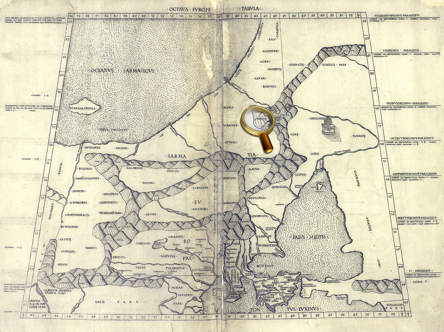
Eight map of Europe [Collection of maps of Claudius Ptolemy. Rome, 1508].
The map shows the area between the Baltic Sea (with parts of Scandinavia) and the Black Sea
(with the Crimean peninsula). The legendary Riphean Mountains are shown on the territory of the European Sarmatia.
К 0-Мир 7/345
Veiw in the Digital Library
Map of South America, compiled for Johannes Janssonius' atlas published in Amsterdam in 1630.
К 0-ЮАм 2/21
Veiw in the Digital Library
Vol. 2. Amsterdam : Apud Iohanem Guiljelmi F. Blaeu, 1645-1650.
Map of North and South America from Vol.2 Willem Blaeu's atlas.
К 0-Мир 8/112_2
Veiw in the Digital Library
World map from Abraham Ortelius' atlas «Theatre of the World», Antwerp, 1570.
«Terra Australis Nondum Cognita» is shown at the bottom of the map.
К 0-Мир 7/11
Veiw in the Digital Library
World map from the world atlas of Gerardus Mercator "Atlas or cosmographical meditations upon the creation of the universe, and the universe as created", Duisburg, 1595.
«Terra Australis» is shown at the bottom of the map.
К 0-Мир 7/10
Veiw in the Digital Library
From the atlas: Theatrum orbis terrarum, Sive Atlas novus …Vol. 1. Amsterdam: J. G. Blaeu, 1645.
World map from Vol.1 of Joan Blaeu's atlas, published in Amsterdam in 1645
«Magallanica. Terra Australis Incognita» is shown at the bottom of the map and on the right of the supplementary map.
К 0-Мир 8/112_1
Veiw in the Digital Library
Map of Tartary or the Kingdom of Great Ham from Abraham Ortelius' atlas «Theatre of the World», Antwerp, 1570.
The map shows the north-eastern part of Asia and the north-western part of America, separated by the Strait Aniane.
К 0-Мир 7/11
Veiw in the Digital Library
From the atlas: Speculum orbis terrӕ. Antverpen, 1593-1613. P. 12.
Maps of part of North America (Quivira) and New Guinea from the world atlas Gerard de Jode
«Mirror of the World». Antwerp, 1593-1613. P. 12.
К 0-Мир 7/9
Veiw in the Digital Library
World map from the world atlas of Gerardus Mercator "Atlas or cosmographical meditations upon the creation of the universe, and the universe as created", Duisburg, 1595.
К 0-Мир 7/10
Veiw in the Digital Library
From the atlas: Theatrum orbis terrarum, Sive Atlas novus …Vol. 1. Amsterdam: J. G. Blaeu, 1645.
World map from Vol.1 of Joan Blaeu's atlas, published in Amsterdam in 1645
К 0-Мир 8/112_1
Veiw in the Digital Library