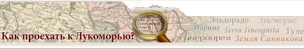
Hyperborea (literally – "beyond Boreas, the North Wind") is a perpetually warm and sunny North land of an ancient Greek legend, where the blessed mythical people live.
There are many interpretations of the description of the country. According to one of them, the Hyperboreans live a blissful life, having eternal fun and feasts, they are always singing, dancing, playing musical instruments. Apollo is venerated among them; the Hyperboreans are incessantly praising him in their hymns. Even death comes to them as a deliverance from the satiation of life: after experiencing all the pleasures, they jump into the sea and thus took their own lives.
Hyperborea is a subject of many studies, including parascientific or occult ones. Various authors place Hyperborea in Greenland, near the Ural Mountains, on the Kola Peninsula, in Karelia, on the Taimyr Peninsula.
Quivira
Quivira a place, which, according to a legend, could be found in the northeast of North America.
The land was watered by a river inhabited by fish, the size of a horse. On the surface of the river, luxury galleys sailed. People used the golden dishes, and their chief was making his daily rest under a tree decorated with little golden bells which lulled him to sleep with their gentle ringing.
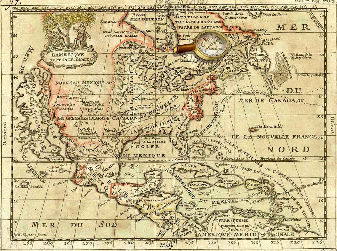
Kingdom of Saguenay
Kingdom of Saguenay (French Royaume du Saguenay) is a country in North America, according to mythology of the Algonquin Indian people, rich with gold, silver and furs.
Following the Indian oral traditions, expeditions of French and French Canadian researchers sought Saguenay to the north of the St. Lawrence River, near the modern district of Saguenay-Lac-Saint-Jean (Quebec), over many decades.
It may well be so that telling the stories of great riches, Indians only wanted to protect their settlements from the greedy Europeans, dooming them to fruitless searches, diseases and death in the harsh climate of the northern regions. However, in the area of Saint-Jean Lake (from which the Saguenay River originates), there are the mildest and most favorable conditions for economic activity on the entire northern coast that possibly gave rise to the legend of the rich kingdom.
Seven Cities of Gold
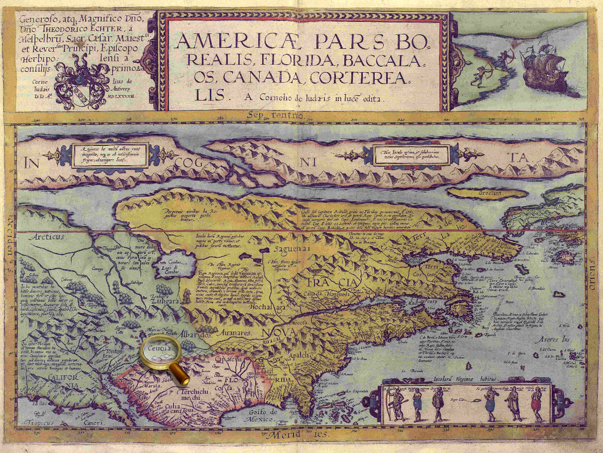
The Seven Cities of Gold called "Cibola", which were considered to be in North America, hundreds of miles north of the colony of New Spain (now Mexico).
Rumours of "Seven Cities of Gold" are supposedly were caused by an old Portuguese legend about seven cities founded by seven Catholic bishops who saved Christian sacred objects from the invasion of the Moors in the 8th century. More recent stories, largely, have their root in the reports drawn up by the shipwreck survivors of the failed Spanish expedition to Florida.
Eventually, these travelers returned to New Spain and told how they had heard stories about the cities of great wealth. This encouraged the Spaniards to organized several expeditions to search for Cibola (its territory is associated with the lands within the present-day states of Arizona and New Mexico). And, although, searches were not successful, Cibola repeatedly were shown on maps.
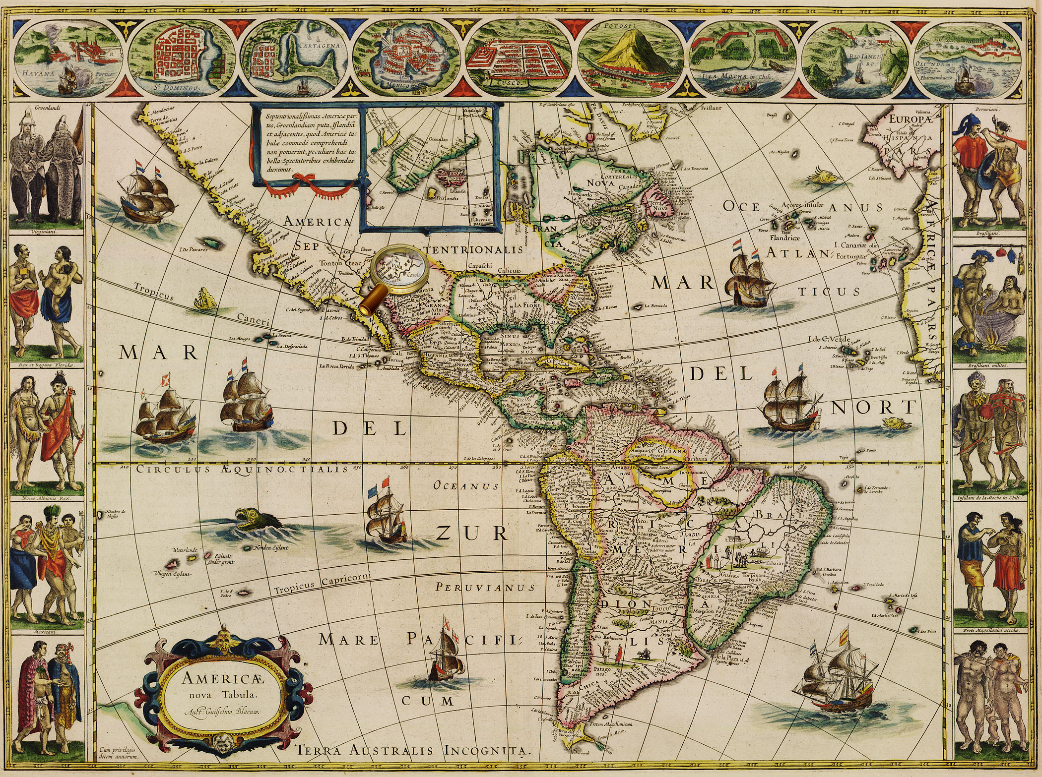
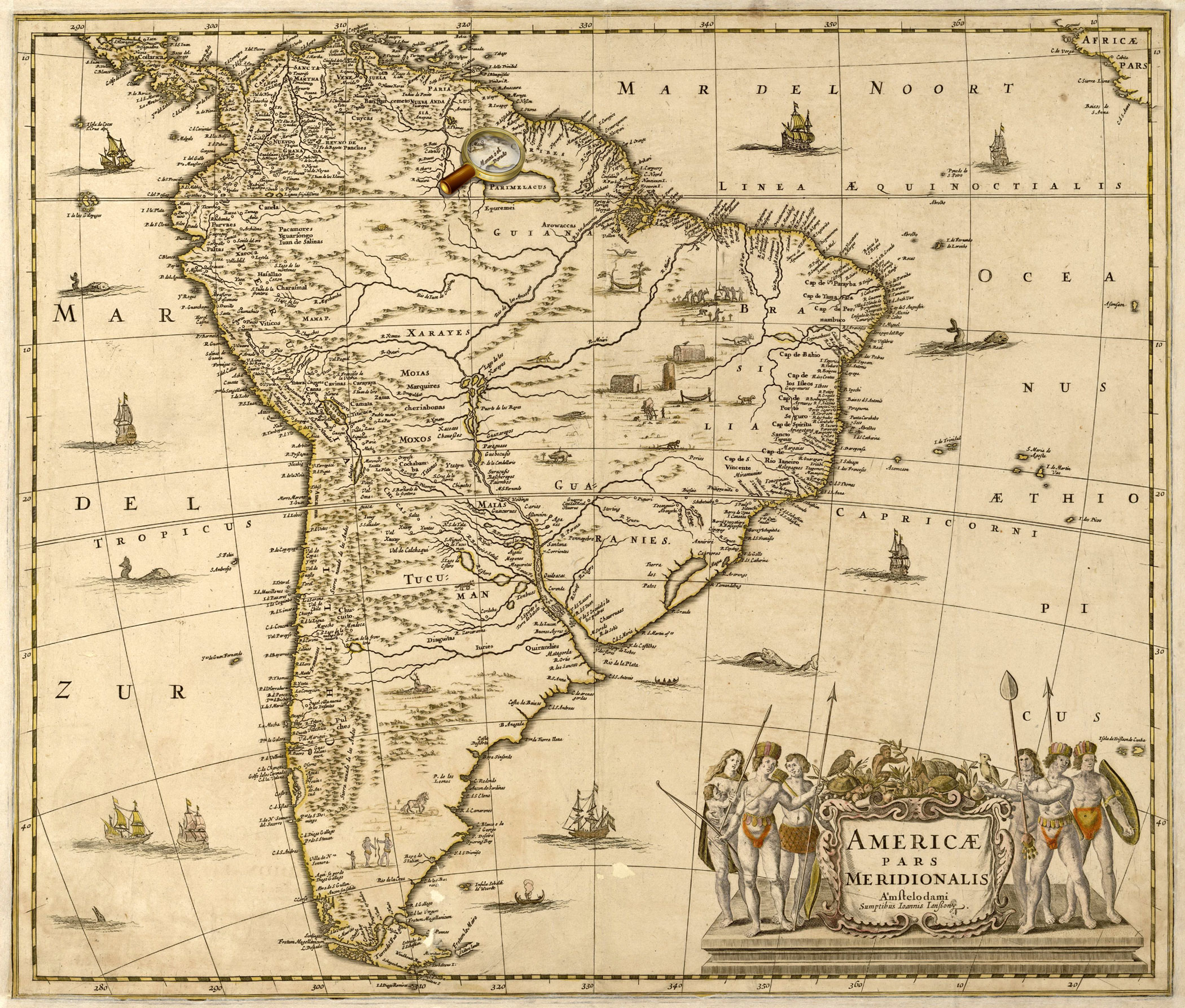
Eldorado
Eldorado (El Dorado) is a mythical country of South America, rich with gold and precious stones. The first legends about this country are connected with the discovery of America.
They have their origin in a custom of the Indian Chibcha people, corresponding to European coronation, when a new chief of the tribe was covered with clay, all his body was powdered with gold dust until he turned into «El hombre dorado» – "a golden man". Then the new chief ceremonially bathed in the lake, leaving precious sand on its bottom.
At different times, the search for Eldorado were conducted first along the coast of Venezuela, then between the Amazon and Orinoco rivers – on the banks of the mythical Lake Parime in Guiana. The search expeditions cost great material expenses and the loss of many human lives, but gave very valuable geographic and ethnographic results.
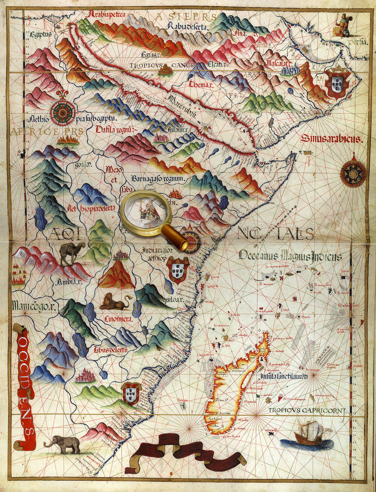
Prester John Reign
The Land of Prester John was thought to lie in Central Asia, according to the original version.
Prester John was considered to be a Christian ruler of a powerful East kingdom full of marvels, peace and harmony. The legend of Prester John was popular in Europe from the mid-twelfth century, depicting Prester John as a descendant of the Three Magi mentioned in the Bible.
In the medieval Crusaders campaign against Muslims, Europeans repeatedly attempted to find the kingdom of the influential Christian priest-king, seeking the help of the potential ally to capture Palestine. In 117, Pope Alexander III even sent a letter to Prester John via his emissary Philip. The Papal envoy, however, never returned. Since the 14th century, the placement of the legendary Prester John's kingdom was transferred to Ethiopia (in fact, Christianity was adopted there in the 4th century). It should be noted that a number of researchers have found historical prototypes of Prester John.
Lukomorye
Lukomorye ( Old Russian for "Sea Bend"), literally, can be translated from Russin as a bay, inlet, or "curved sea-shore".
In the folklore of eastern Slavs, it is a secret place on the edge of the universe, where the world tree grows. The tree extends to the heavens and its roots reach the underworld; it is the world axis which helps to travel from one world to another. The gods descend and climb up the world tree.
Some studies described an ancient Northern Kingdom "Lukomorye" where people go into hibernation to wake up with the return of the spring sun.
The land of "Lucomoria" was also depicted in West-European early maps of Siberia/Muscovy. It, usually, indicates the territory adjacent to the right (east) bank of the Ob Bay. In the Russian historical cartography such a place name is not found. But the toponym is mentioned in The Tale of Igor's Campaign and the Russian chronicles.
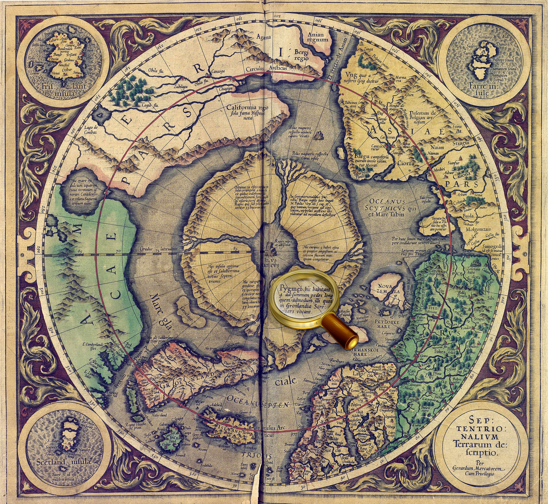
Septentrionalium Terrarum descriptio. From the atlas: Atlas sive Cosmographicæ Meditationes…Duisburg, 1595. P. 1.
Map of the North Pole from the world atlas of Gerardus Mercator "Atlas or cosmographical meditations upon the creation of the universe, and the universe as created", Duisburg, 1595.
One of the four polar islands has an inscription, 'It is home to the pygmies' that some sources interpreted as an indication of the legendary Hyperborea. K 0-Mir 7/10 Veiw in the Digital Library
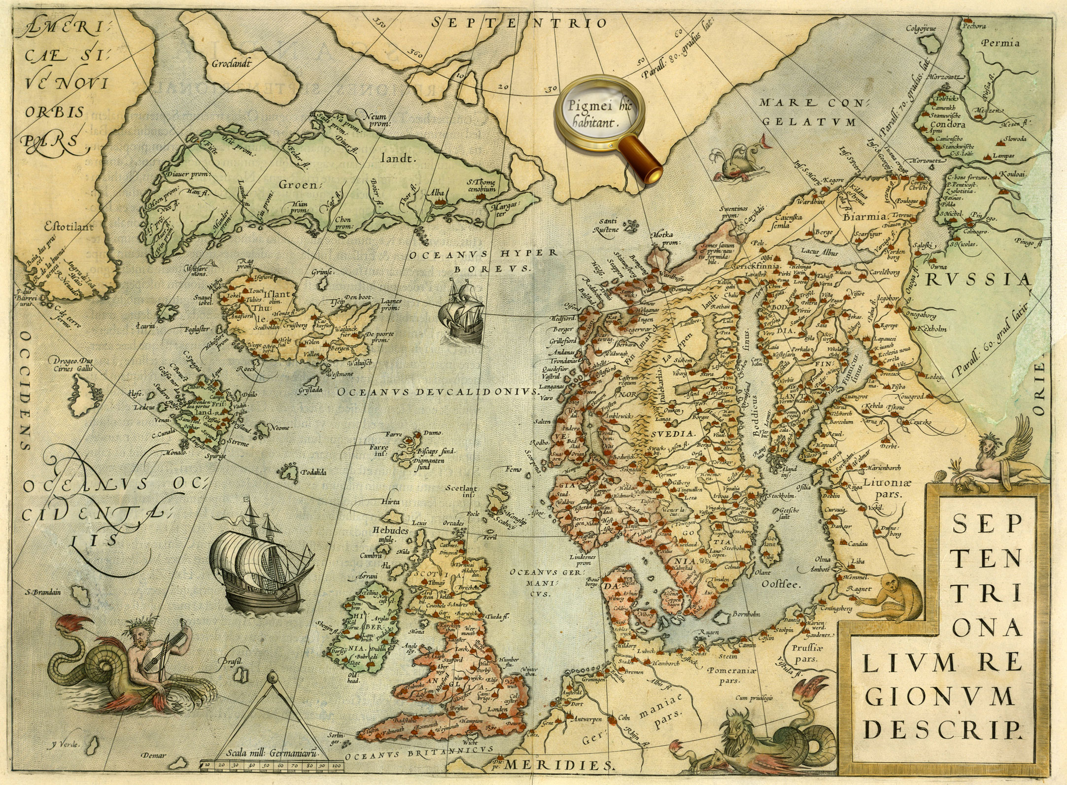
Septentrionalium regionum descrip. From the atlas: Theatrum orbis terrarum. Antverpen, 1570. P. 45.
Map of the Scandinavia from Abraham Ortelius' atlas «Theatre of the World», published in Antwerp in 1570.
One of the four polar islands has an inscription, 'It is home to the pygmies' that some sources interpreted as an indication of the legendary Hyperborea. К 0-Мир 7/11 Veiw in the Digital Library
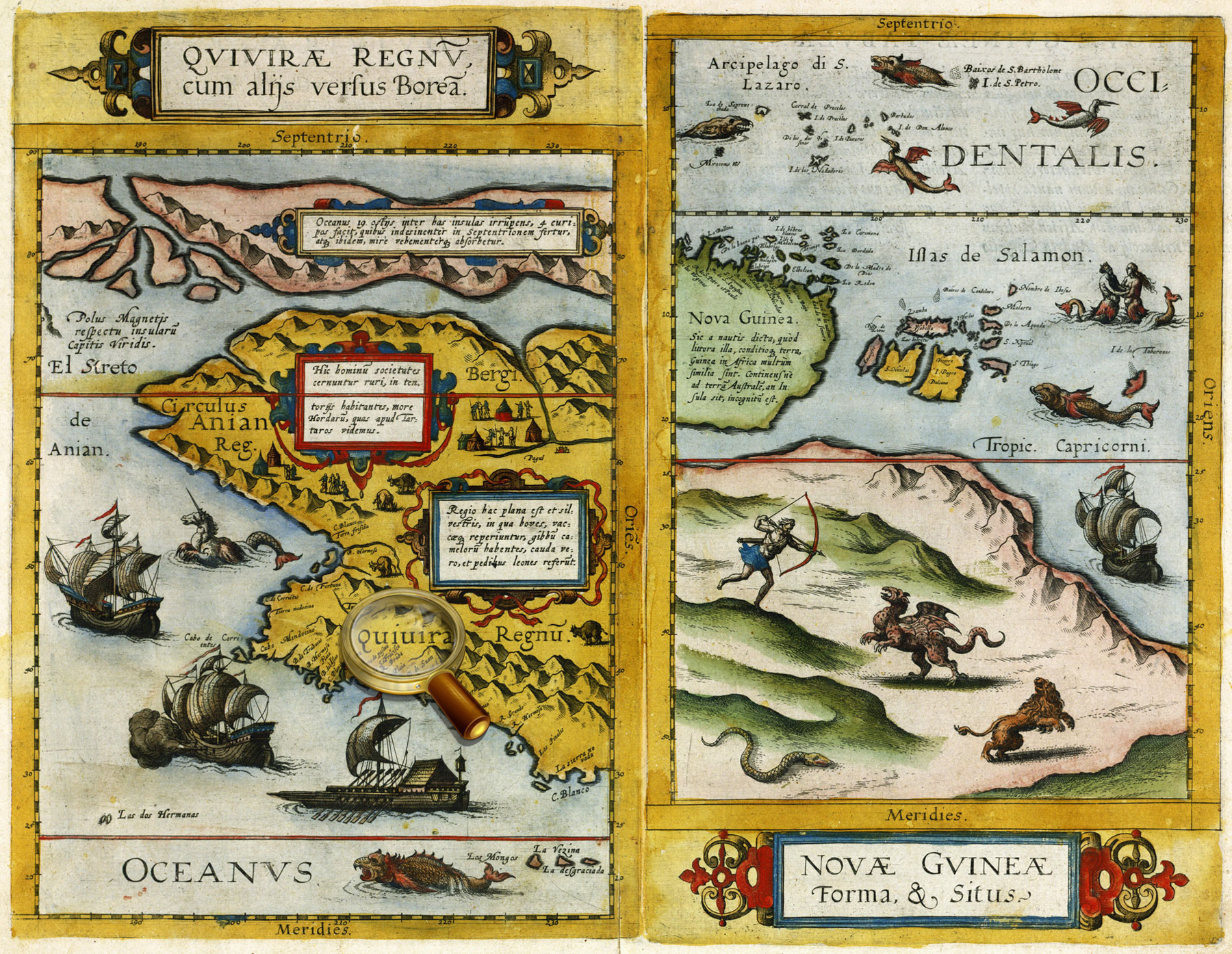
Quivirae regnum, cum aliis versus Boream. Novae Gvineae Forma & Situs. From the atlas: Speculum orbis terrӕ. Antverpea, 1593-1613. P. 12.
Maps of part of North America (Quivira) and New Guinea from the world atlas Gerard de Jode «Mirror of the World». Antwerp, 1593-1613. P.12.
The map of Quivira contains a text in which residents of the area are compared with the Tatars – a reference to the theory that North America was part of Asia and was populated by immigrants from Asia.
К 0-Мир 7/9 Veiw in the Digital Library
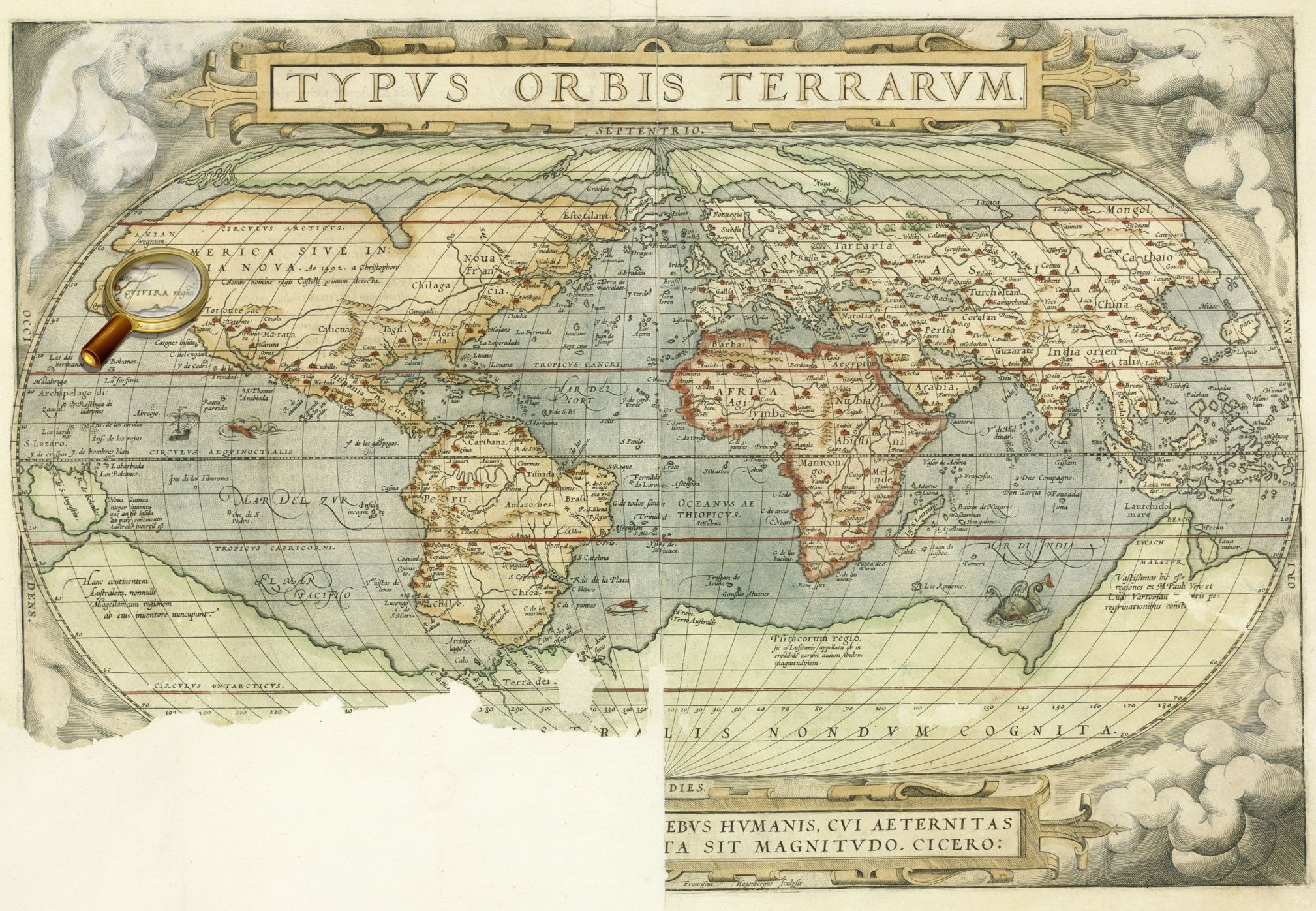
Typus orbis terrarum. From the atlas: Theatrum orbis terrarum. Antverpen, 1570. P. 1.
World map from Abraham Ortelius' atlas «Theatre of the World», published in Antwerp in 1570
К 0-Мир 7/11 Veiw in the Digital Library
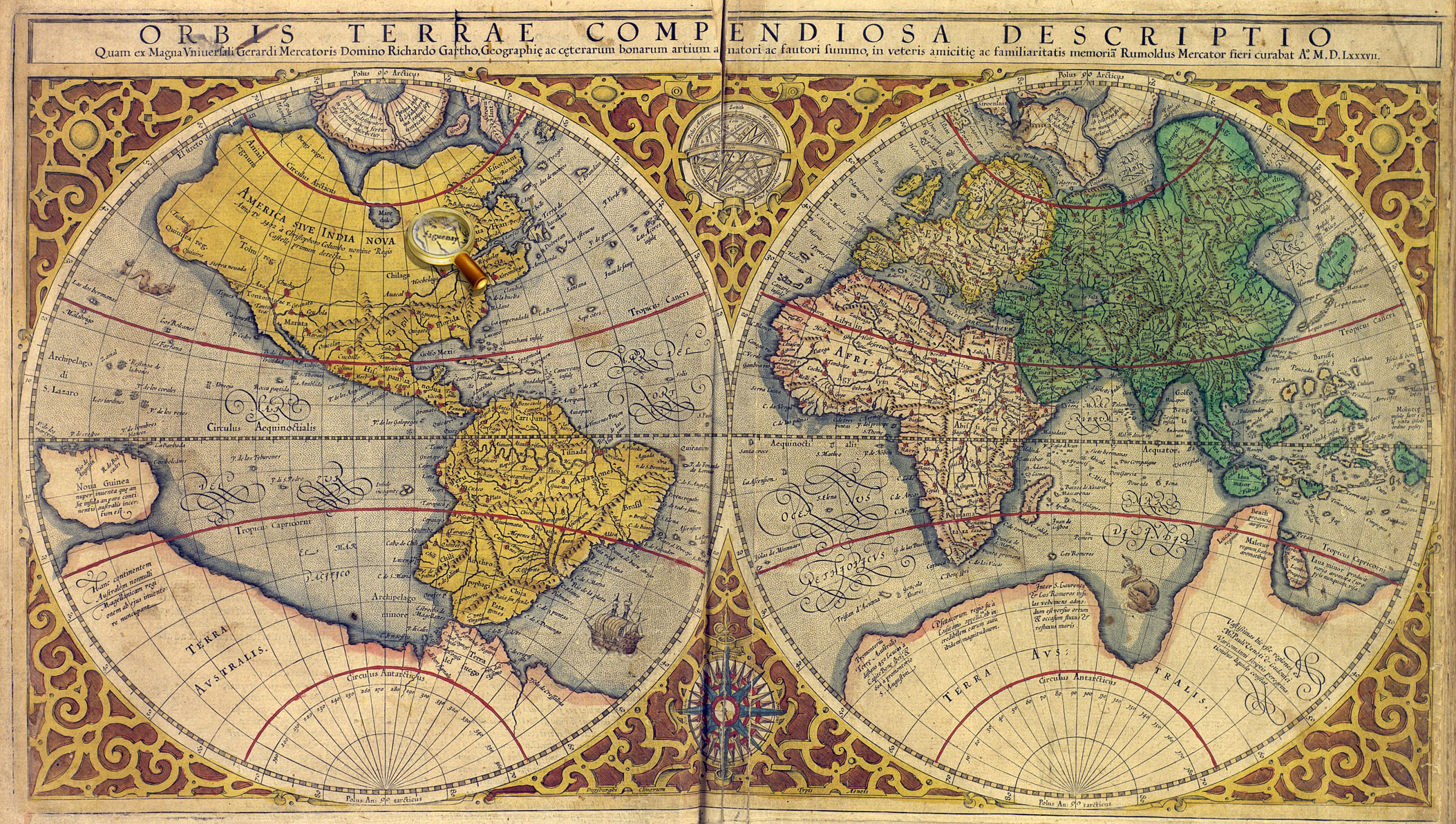
Orbis terrae compendiosa descriptio. From the atlas: Atlas sive Cosmographicæ Meditationes…Duisburg, 1595. [P. 1].
World map from the world atlas of Gerardus Mercator "Atlas or cosmographical meditations upon the creation of the universe, and the universe as created", Duisburg, 1595.
К 0-Мир 7/10 Veiw in the Digital Library
Nova totius terrarum orbis geographica ac hydrographica tabula. Auct. Guilj. Blaeuw. From the atlas: Theatrum orbis terrarum, Sive Atlas novus …Vol. 1. Amsterdam: J. G. Blaeu, 1645.
World map from Vol.1 of Joan Blaeu's atlas, published in Amsterdam in 1645 К 0-Мир 8/112_1 Veiw in the Digital Library
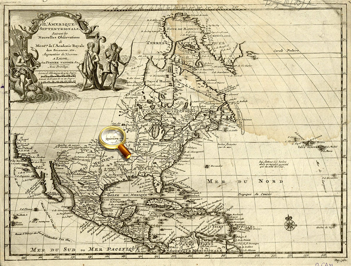
L’ Amerique Septentrionale Suivant les Nouvelles observations de mess-rs de l’ Academie Royale des Sciences etc, augmentees de nouveau. Avec privil.. - Leide : chez Pierre van der Aa, 16…?].
Map of North America. К 0-САм 1/3 Veiw in the Digital Library
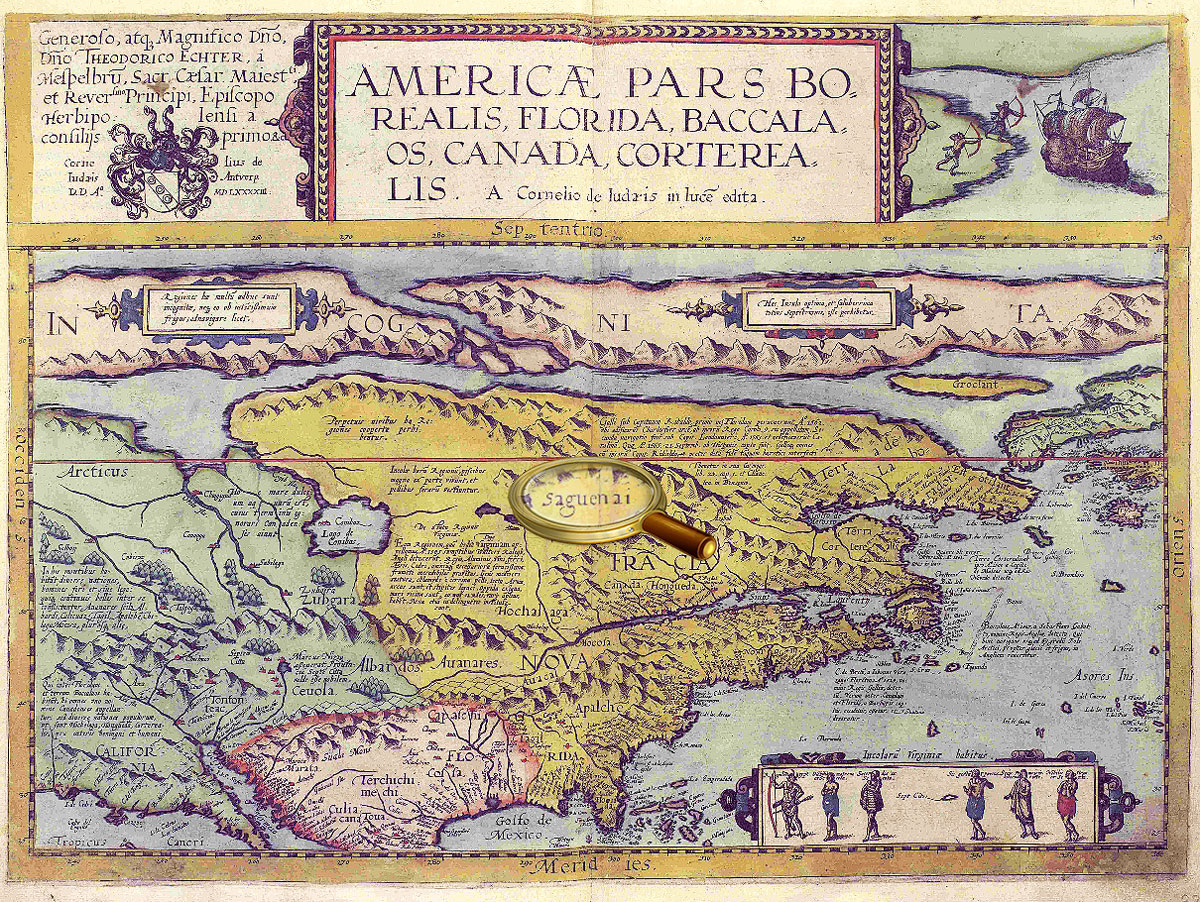
Americae Pars Borealis, Florida, Baccalaos, Canada, Corterealis…From the atlas: Speculum orbis terrӕ. Antverpiae, 1593-1613. P. 11.
Map of part of North America from the world atlas Gerard de Jode «Mirror of the World». Antwerp, 1593-1613. P.11. К 0-Мир 7/9 Veiw in the Digital Library
Orbis terrae compendiosa descriptio. From the atlas: Atlas sive Cosmographicæ Meditationes…Duisburg, 1595. [P. 1].
World map from the world atlas of Gerardus Mercator "Atlas or cosmographical meditations upon the creation of the universe, and the universe as created", Duisburg, 1595.
К 0-Мир 7/10 Veiw in the Digital Library
L’ Amerique Septentrionale. M. Ogier fecit.. - S.l., [late 17th cent.]. Map of North America. К 0-САм 1/4 Veiw in the Digital Library
L’ Amerique Septentrionale Suivant les Nouvelles observations de mess-rs de l’ Academie Royale des Sciences etc, augmentees de nouveau. Avec privil.. - Leide : chez Pierre van der Aa, 16…?].
Map of North America. К 0-САм 1/3 Veiw in the Digital Library
Americae Pars Borealis, Florida, Baccalaos, Canada, Corterealis…From the atlas: Speculum orbis terrӕ. Antverpiae, 1593-1613. P. 12. Map of part of North America from the world atlas Gerard de Jode «Mirror of the World». Antwerp, 1593-1613. P. 11. К 0-Мир 7/9 Veiw in the Digital Library
Orbis terrae compendiosa descriptio. From the atlas: Atlas sive Cosmographicæ Meditationes…Duisburg, 1595. [P. 1].
World map from the world atlas of Gerardus Mercator "Atlas or cosmographical meditations upon the creation of the universe, and the universe as created", Duisburg, 1595.
К 0-Мир 7/10 Veiw in the Digital Library
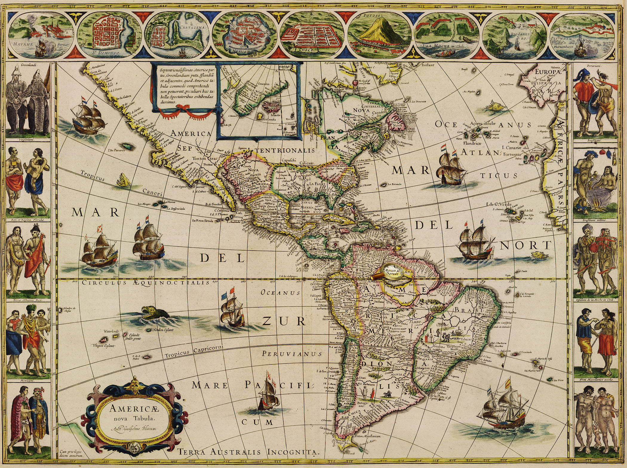
Americae nova tabula. Auct. Guiljelmo Blaeuw. From the atlas: Theatrum Orbis Terrarum, sive Atlas Novus. Vol. 2. Amsterdam : Apud Iohanem Guiljelmi F. Blaeu, 1645. Map of North and South America from Vol. 2 of Joan Blaeu's atlas, published in Amsterdam in 1645 К 0-Мир 8/112_2 Veiw in the Digital Library
Americaу Pars Meridionalis. – Amstelodami: J. Janssoniy, [after 1630 Map of South America From Johannes Janssonius' atlas, published in Amsterdam in 1630. On the shore of Lakes Parime, there is an inscription "Manoa, or El Dorado. К 0-ЮАм 2/21 Veiw in the Digital Library
Americae nova tabula. Auct. Guiljelmo Blaeuw. From the atlas: Theatrum Orbis Terrarum, sive Atlas Novus. Vol. 2. Amsterdam: J/ G. Blaeu, 1645.
Map of North and South America from Vol. 2 of Joan Blaeu's atlas, published in Amsterdam in 1645 К 0-Мир 8/112_2 Veiw in the Digital Library
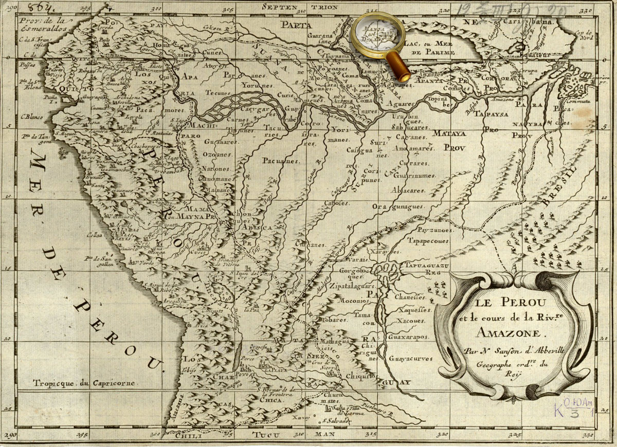
Le Perou et le cours de la Riv.re Amazone. Par N.Sanson d’Abbeville Geographe ord.-re du Roy. [Paris, 1683].
On the shore of Lake Parime (Parime) is an inscription «Manoa, or Eldorado». К 0-ЮАм 1/3 Veiw in the Digital Library
America Meridionalis Concinnata juxta Observayiones… Per G. de l'Isle. Augustæ Vindel, Vol. C. Lotter, [1770].
Map of South America, compiled by G. Delisle in 1700, and reprinted by the Lotter publishing house after 1760 The legendary country Eldorado is marked on the area called Terra Firma («mainland province» of Spain in contrast to the neighboring island colonies of Spain), present-day part of Venezuela and Colombia. К 1-ЮАм 2/27 Veiw in the Digital Library
[Madagascar, North-East Africa, Red Sea, Arabia] from the facsimile of the Atlas Universal. Diogo Homem, [1565. Barselona, 2000. Map of 8.]
The map shows the east coast of Africa. A figure of the Christian king [Prester John], often shown on the maps of the 15th-16th centuries, is placed in the center, in what is now Ethiopia. К 4-Мир 28/3794
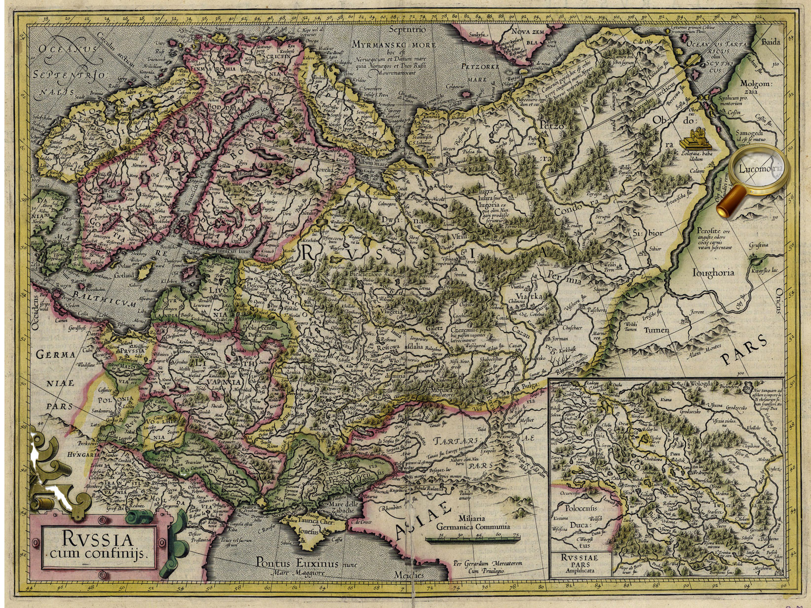
Russia cum confinÿs. Per Gerardum Mercatorem. Cum privilegio. [Amsterdam, 1633].
Map of Russia from the atlas of G. Mercator – J. Hondius, Amsterdam, 1633.
One of the earliest map Russia, created by foreign cartographers. On the territory of the Asian part of Russia, there is depicted Lucomoria.
К 0-МоскЕ 2/19 Veiw in the Digital Library
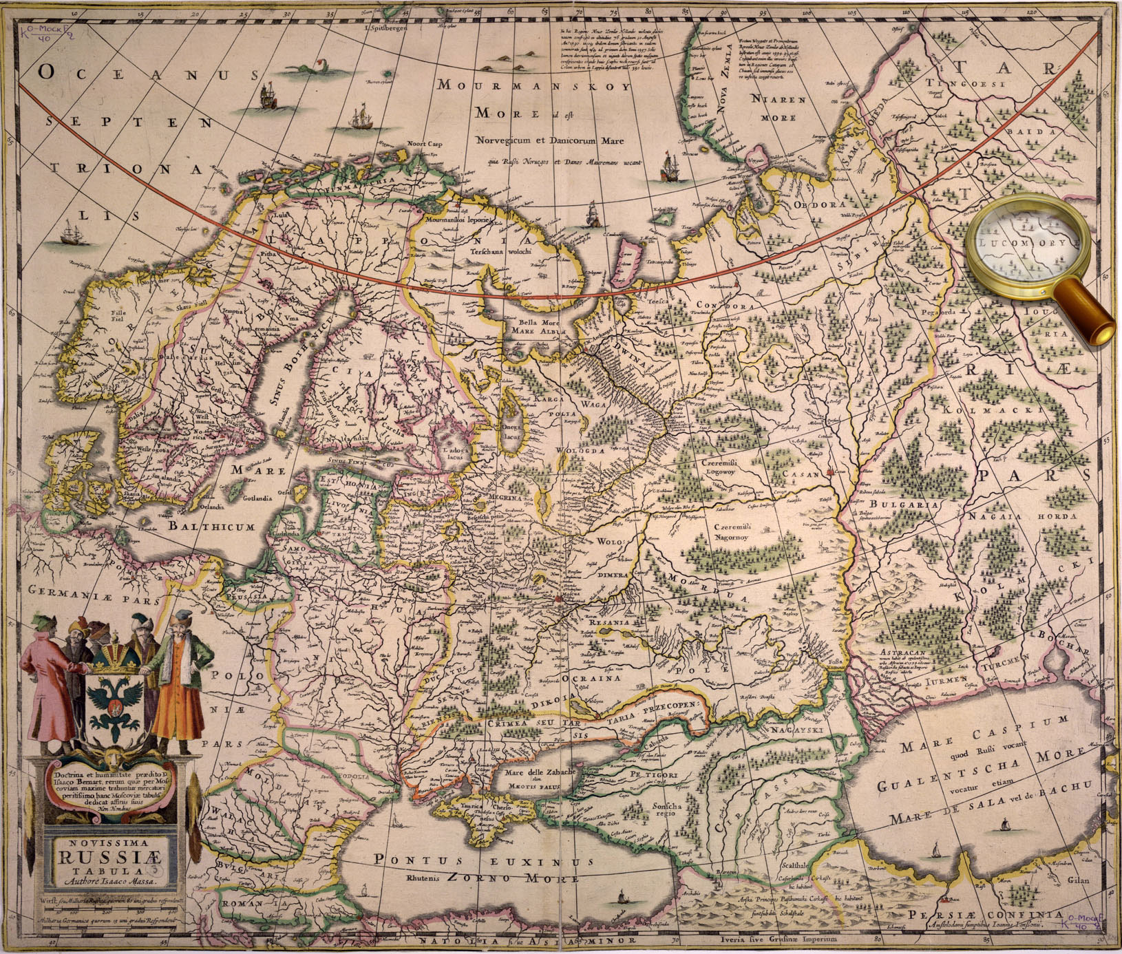
Novissima Russiae Tabula….. Authore Isaaco Massa. Amstelodami, Hen. Hondius, sumptibus Joannis Janssonii. - Amstelodami : Hen. Hondius, sumptibus Joannis Janssonii, [1644]
Map of Russia From the atlas мира J. Hondius- J.Janssonius, Amsterdam, 1644.
One of the earliest map Russia, created by foreign cartographers. On the territory of the Asian part of Russia, there is depicted Lucomoria. К 0-МоскЕ 2/40 Veiw in the Digital Library
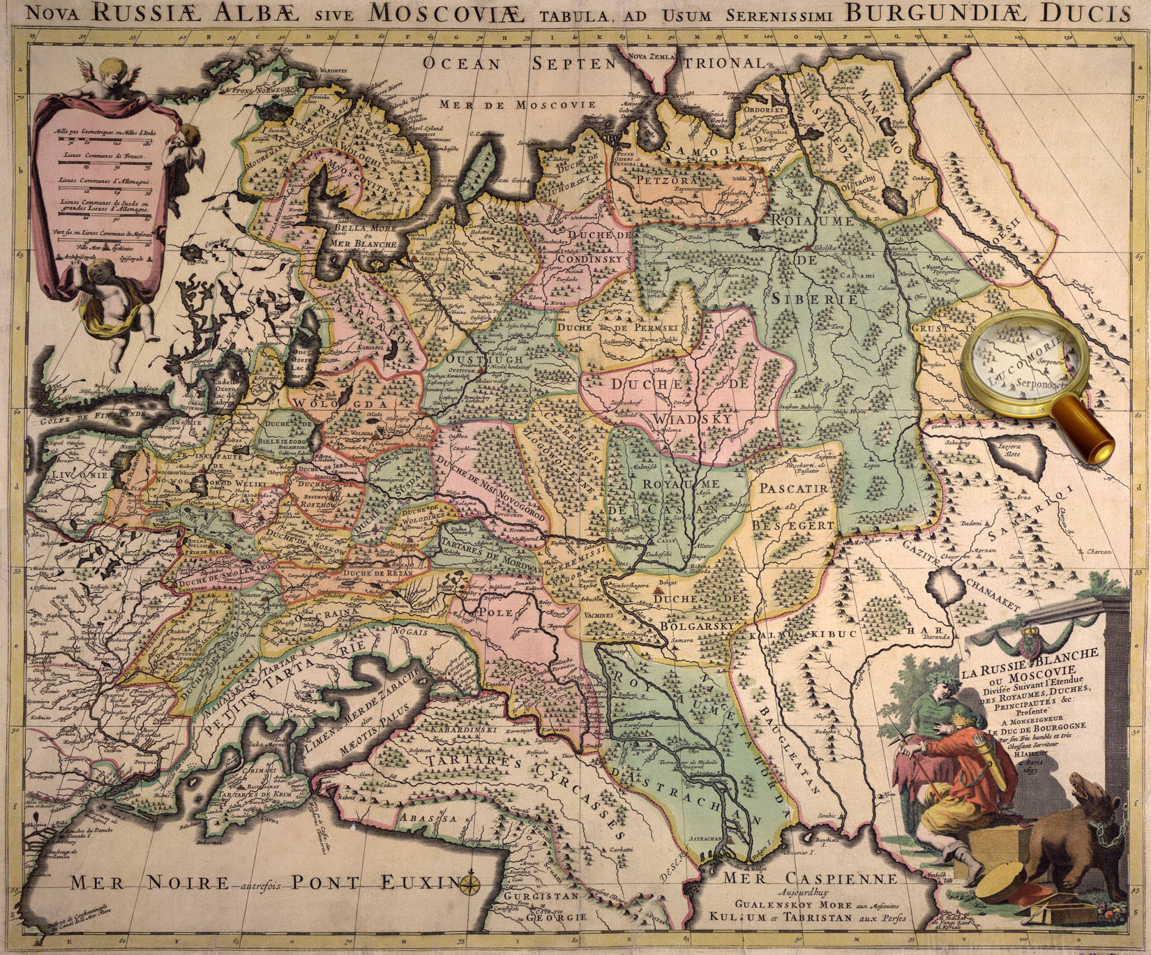
La Russie Blanche ou Moscovie Divisée suivant l’Etendu des Royaumes, Duchés, Principautés etc. Presenté à Monseigneur le Duc de Bourgogne par… H.Jaillot. - Paris, 1695.
One of the earliest map Russia, created by foreign cartographers. On the territory of the Asian part of Russia, there is depicted Lucomoria. К 0-МоскЕ 2/50 Veiw in the Digital Library
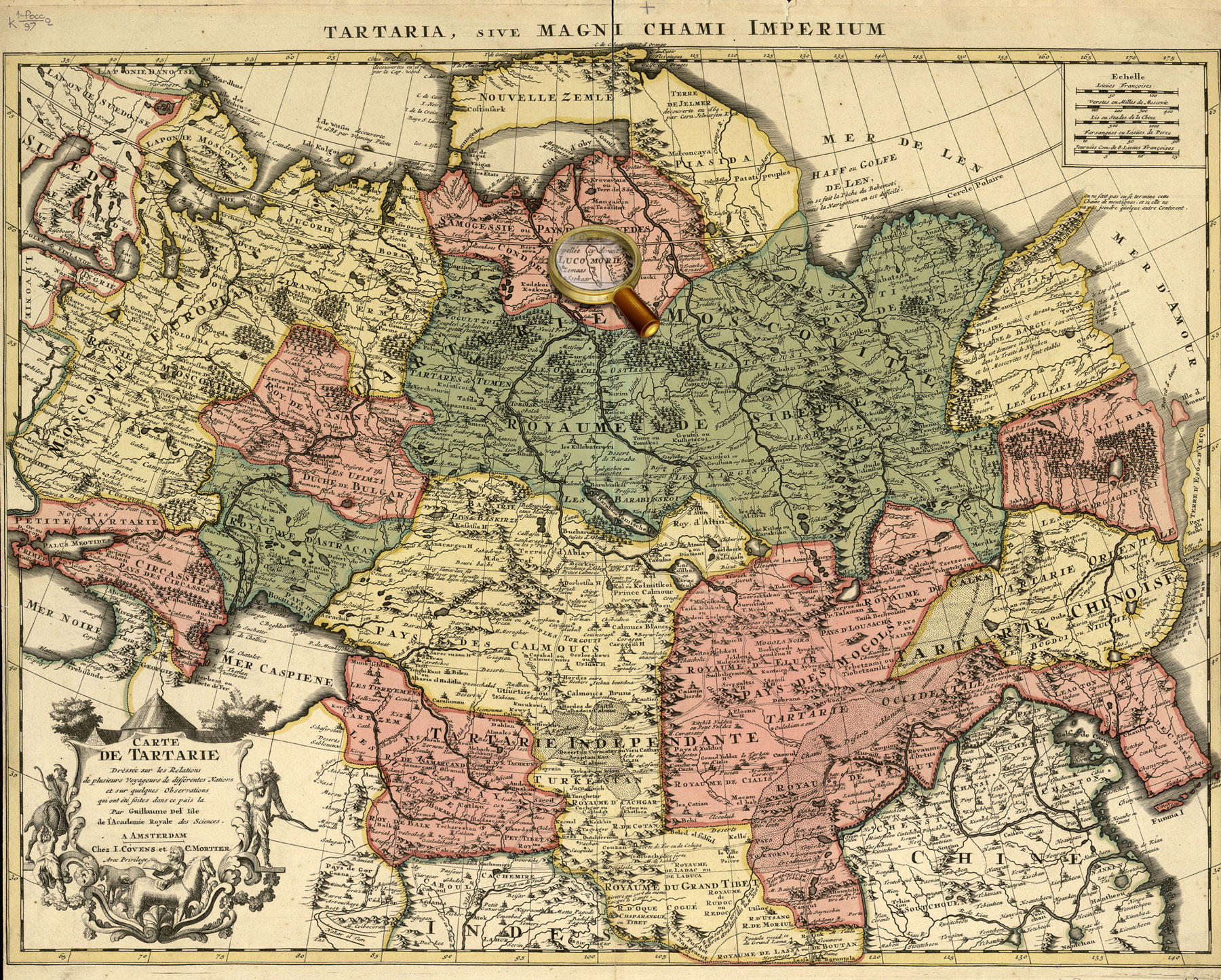
Carte Tartarie. Dressée sur les Relations de plusieurs Voyageurs de differentes Nations et sur quelques observations qui ont été faites dans ce pais là Par Guillaume de l'Isle Avec Privil. Amsterdam, chez J. Covens et C. Mortier [1720?].
Map of Tartary, compiled by G. Delisle using materials of many travelers, and published in Amsterdamе in ca. 1720. In the northern part of the map , there is an inscription «Lukomoria».
Septentrionalium Terrarum descriptio. From the atlas: Atlas sive Cosmographicæ Meditationes…Duisburg, 1595. P. 1. Map of Noth Pole from the world atlas of Gerardus Mercator "Atlas or cosmographical meditations upon the creation of the universe, and the universe as created", Duisburg, 1595.
Island Friesland is shown on the map at the bottom, on the left of Iceland, and is given an supplementary map on the top left. К 0-Мир 7/10 Veiw in the Digital Library
Typus orbis terrarum. From the atlas: Theatrum orbis terrarum. Antverpen, 1570. P. 1.
World map from Abraham Ortelius' atlas «Theatre of the World», Antwerp, 1570. К 0-Мир 7/11 Veiw in the Digital Library
Septentrionalium regionum descrip. From the atlas: Theatrum orbis terrarum. Antverpen, 1570. P. 45.
Map of Scandinavia from Abraham Ortelius' atlas «Theatre of the World», Antwerp, 1570. К 0-Мир 7/11 Veiw in the Digital Library
Nova totius terrarum orbis geographica ac hydrographica tabula. Auct. Guiljelmo Blaeuw. From the atlas: Theatrum orbis terrarum, Sive Atlas novus …Vol. 1. Amsterdam: J. G. Blaeu, 1645.
World map from Vol.1 of Joan Blaeu's atlas, published in Amsterdam in 1645 К 0-Мир 8/112_1 Veiw in the Digital Library
Typus orbis terrarum. From the atlas: Theatrum orbis terrarum. Antverpen, 1570. P. 1.
World map from Abraham Ortelius' atlas «Theatre of the World», Antwerp, 1570. К 0-Мир 7/11 Veiw in the Digital Library
Septentrionalium regionum descrip. From the atlas: Theatrum orbis terrarum. Antverpen, 1570. P. 45.
Map of Scandinavia from Abraham Ortelius' atlas «Theatre of the World», Antwerp, 1570. К 0-Мир 7/11 Veiw in the Digital Library
Septentrionalium regionum descrip. From the atlas: Theatrum orbis terrarum. Antverpen, 1570. P. 45.
Map of Scandinavia from Abraham Ortelius' atlas «Theatre of the World», Antwerp, 1570. Replica. К 0-Мир 7/11 Veiw in the Digital Library
Nova totius terrarum orbis geographica ac hydrographica tabula. Auct. Guiljelmo Blaeuw. From the atlas: Theatrum orbis terrarum, Sive Atlas novus …Vol. 1. Amsterdam: J. G. Blaeu, 1645.
World map from Vol.1 of Joan Blaeu's atlas, published in Amsterdam in 1645 К 0-Мир 8/112_1 Veiw in the Digital Library
[Carta marine… Anno 1539,… Olaus Magnus…] Romæ, Antony Lafrery, 1572.
Replica. «Carta Marina» is one of the earliest and most reliable historical maps of North Europe, created by the Swedish church figure, diplomat and writer Olaus Magnus. He used as personal travel notes, cards Scandinavian sailors and maps from Ptolemy's Geography as the sources for the map. Besides a detailed picture of geographic features, the map contains more than 100 miniatures depicting real and imaginary animals, local customs and costumes, historical events, and fabulous lands, including - the island Thule (Tile). К 0-Ск 3/36 Veiw in the Digital Library
Septentrionalium regionum descrip. From the atlas: Theatrum orbis terrarum. Antverpen, 1570. P. 45.
Map of Scandinavia from Abraham Ortelius' atlas «Theatre of the World», Antwerp, 1570. К 0-Мир 7/11 Veiw in the Digital Library
Septentrionalium Terrarum descriptio. From the atlas: Atlas sive Cosmographicæ Meditationes…Duisburg, 1595. P. 1. Map of North Pole from the world atlas of Gerardus Mercator "Atlas or cosmographical meditations upon the creation of the universe, and the universe as created", Duisburg, 1595.
In the center of the map, there was dipicted the Black Rock (Rupes Nigra) located at the North Pole and having magnetic properties, according to Mercator, which has magnetic properties. In addition, based on his studies of the magnetic poles and the researches of other scientists, Gerardus Mercator mapped two islands indicated as magnetic: rocky one and a very small isle shown as a circle. К 0-Мир 7/10 Veiw in the Digital Library
The latest map of Eastern Siberia, compiled in 1816. [Without place], 1816.
On the map, in the Arctic Ocean, there is an inscription, 'Land seen by Sannikov' К 2-Сиб 1/12 Veiw in the Digital Library
Map of Asiatic part of Russia and Turkestan region. To the project of the South-Siberian Railroad Orsk-Pavlodar-Barnaul by the engineer P.I. Rashevsky, dated to 1913. [Without place], 1913. The map shows Sannikov Land in the Arctic Ocean. К 3-Сиб 3/38 Veiw in the Digital Library
Map of polar regions of the Asian and American continents. Compiled by Prince Alexey Dolgoruky according to the testimony of clairvoyants. [St. Petersburg], Lithography of J. Lapping, 1852. К 3-Арк 1/25 Veiw in the Digital Library
Illustration to the article: B.S. Lukshin. Arctic knot of military-political relations between US and Russia /
Pacific Ocean. South part. From the atlas: Marine Atlas. Editor-in-chief Professor Fleet Admiral I.S. Isakov. Vol.1. Navigational and Geographical. [P.6 ], Naval General Staff, 1950-1963. The map shows Reef Maria Teresa in the Pacific Ocean. К 4-Мир 8/796
Octava Europe Tabula. From the atlas: [Collection of maps of Claudius Ptolemy. Rome, 1508. Map 8.].
Eight map of Europe [Collection of maps of Claudius Ptolemy. Rome, 1508].
The map shows the area between the Baltic Sea (with parts of Scandinavia) and the Black Sea (with the Crimean peninsula). The legendary Riphean Mountains are shown on the territory of the European Sarmatia. К 0-Мир 7/345 Veiw in the Digital Library
America Pars Meridionalis. – Amstelodami: J. Janssoniy, [after 1630].
Map of South America, compiled for Johannes Janssonius' atlas published in Amsterdam in 1630.
К 0-ЮАм 2/21 Veiw in the Digital Library
Americae nova tabula. Auct. Guiljelmo Blaeuw. From the atlas: Theatrum Orbis Terrarum, sive Atlas Novus. Vol. 2. Amsterdam : Apud Iohanem Guiljelmi F. Blaeu, 1645-1650.
Map of North and South America from Vol.2 Willem Blaeu's atlas. К 0-Мир 8/112_2 Veiw in the Digital Library
Typus orbis terrarum. From the atlas: Theatrum orbis terrarum. Antverpen, 1570. P. 1.
World map from Abraham Ortelius' atlas «Theatre of the World», Antwerp, 1570. «Terra Australis Nondum Cognita» is shown at the bottom of the map.
К 0-Мир 7/11 Veiw in the Digital Library
Orbis terrae compendiosa descriptio. From the atlas: Atlas sive Cosmographicæ Meditationes…Duisburg, 1595. [P. 1].
World map from the world atlas of Gerardus Mercator "Atlas or cosmographical meditations upon the creation of the universe, and the universe as created", Duisburg, 1595.
«Terra Australis» is shown at the bottom of the map. К 0-Мир 7/10 Veiw in the Digital Library
Nova totius terrarum orbis geographica ac hydrographica tabula. Auct. Guiljelmo Blaeuw. From the atlas: Theatrum orbis terrarum, Sive Atlas novus …Vol. 1. Amsterdam: J. G. Blaeu, 1645.
World map from Vol.1 of Joan Blaeu's atlas, published in Amsterdam in 1645
«Magallanica. Terra Australis Incognita» is shown at the bottom of the map and on the right of the supplementary map. К 0-Мир 8/112_1 Veiw in the Digital Library
Tartariae sive magni chami regni. From the atlas: Theatrum orbis terrarum. Antverpen, 1570. [P. 47]
Map of Tartary or the Kingdom of Great Ham from Abraham Ortelius' atlas «Theatre of the World», Antwerp, 1570.
The map shows the north-eastern part of Asia and the north-western part of America, separated by the Strait Aniane.
К 0-Мир 7/11 Veiw in the Digital Library
Quivirae regnum cum aliis versus Boream. Nоvae Gvineae Forma & Situs. From the atlas: Speculum orbis terrӕ. Antverpen, 1593-1613. P. 12.
Maps of part of North America (Quivira) and New Guinea from the world atlas Gerard de Jode «Mirror of the World». Antwerp, 1593-1613. P. 12.
К 0-Мир 7/9 Veiw in the Digital Library
Orbis terrae compendiosa descriptio. From the atlas: Atlas sive Cosmographicæ Meditationes…Duisburg, 1595. [P. 1].
World map from the world atlas of Gerardus Mercator "Atlas or cosmographical meditations upon the creation of the universe, and the universe as created", Duisburg, 1595.
К 0-Мир 7/10 Veiw in the Digital Library
Nova totius terrarum orbis geographica ac hydrographica tabula. Auct. Guiljelmo Blaeuw. From the atlas: Theatrum orbis terrarum, Sive Atlas novus …Vol. 1. Amsterdam: J. G. Blaeu, 1645.
World map from Vol.1 of Joan Blaeu's atlas, published in Amsterdam in 1645 К 0-Мир 8/112_1 Veiw in the Digital Library


 The Land of Prester John was thought to lie in Central Asia, according to the original version.