Lomonosov and the Geography Department of the Russian Academy of Sciences (1758-1765)
Mikhail Lomonosov, 1711â65, stands out in history as a figure of world importance and true representative of universal man: scientist and scholar, poet and writer, grammarian and historian, artist and philosopher.
Mikhail Lomonosov became a head of the Geography Department in 1758. A year before his official appointment, Lomonosov got closely acquainted with the situation and developed a detailed plan to remove "excesses, shortcomings and obstructions" in the Geography Department.
He outlined three areas of future work: the institutional strengthening of the department, reinforcement of its personnel with Russian surveyors and cartographers, provision of accurate scientific data and reliable geographical information necessary for cartographic work. In the instruction dated 3 October 1757, M.V. Lomonosov defined strict rules for the department staff, and the organizational and methodological principles of map making. It was intended to discuss collectively all the theoretical, methodological and technical issues and progress reports at the weekly meetings, to carry out work on revising the atlas of 1745 through the use of the newest materials, to mainain records for maps, to exclude any hypothetical elements of map content, not based on verified data. In addition, the plan's objectives include the collegial discussion and approval of original author's maps by the general meeting of the Department; arrange for the systematic identification, acquisition and storage of manuscripts and printed cartographic materials - sources of map construction. Mikhail Lomonosov commissioned Professor N.I. Popov and A.D. Krasilnikov to teach theoretical and practical astronomy to students in the academic high school and the university, and adjunct J.F. Schmidt and I.F. Truskott to train them on map-making.
Believing that the main task of the Geography Department is to improve the geometric accuracy along with the content of the produced maps, Lomonosov wrote a number of scientific manuals: "Opinion on sending astronomers and surveyors to the locations in Russia for which it is highly necessary to determine Latitude and Longitude" (1759), "The notion of geographical expeditions", "Sample instruction for expeditions" and "Opinion on using the current revision for the benefit of geography in Russia and composition of the new atlas"(1764). Unfortunately, Lomonosov's initiatives have not been fully implemented because of the difficult relations with the leadership of the Academy, but they are largely prepared academic expeditions of 1768-1774.
At his suggestion in 1761, "geographic questionnaires", consisting of 30 items, were sent to the governments and the provinces of Russia to collect information about the nature and the economic geography of these territories. By 1764, the Department of Geography compiled 4 volumes of responses to the survey questions, which provided detailed topographic information about a half of the country.
Lomonosov suggested a plan of the nautical expedition led by Vasili Chichagov, which made an attempt to navigate the Northern Sea Route. The expedition of 1765-1766 started from Svalbardand and reached 80ÂḞ30'N, but Chichagov failed to sail through the passage. Direct implementation of Lomonosov's proposal were astronomical expeditions by Ivan Islenyev (1768-1773) and Petr Inohodtsev (1781-1785).
Lomonosov was the author of many cartographic works. Among the most significant are the first (1757) and the second (1764) maps of the circumpolar regions and the first Russian educational globe released at his own expense in an edition of 1000 copies. An early version of the second Lomonosov "circumpolar" map was published in 1764 in the joint Soviet-American collection Russia and the United States. The Establishment of Relations, 1765-1815 (Moscow, 1980).
Apart from the general geographical works of Lomonosov, his Essay on the Great Accuracy of the Sea Route (1759) and Short Statement about the Origin of the Geography Department" (1763) are of vital importance for the history of the national cartography. In them he emphasizes that two steps are needed to produce a map: 1. Study cartographic materials - sources of information. 2. Select and compile the content elements. Lomonosov also clearly specified another requirement for cartographic practice: in "New Rules of the Academy" (1764), he stressed the necessity to regularly update maps every 20 years.
All Lomonosov's life and occupational aspirations were aimed at promoting the application of science for the benefit of Russia's people and the Russian state. During his administration of the Geography Department in 1758-1765, three maps were published and nine ones were prepared for publication. Lomonosov's activities gave impetus to the further development of mapping in the Russian Empire, helped elevate the role of the Academy of Sciences in the life of Russian society.
Lomonosov suggested a plan of the nautical expedition led by Vasili Chichagov, which made an attempt to navigate the Northern Sea Route. The expedition of 1765-1766 started from Svalbard and reached 80ÂḞ30'N, but Chichagov failed to sail through the passage. Direct implementation of Lomonosov's proposal were astronomical expeditions by Ivan Islenyev (1768-1773) and Petr Inokhodtsev (1781-1785).
Lomonosov was the author of many cartographic works. Among the most significant are the first (1757) and the second (1764) maps of the circumpolar regions and the first Russian educational globe released at his own expense in an edition of 1000 copies. An early version of the second Lomonosov "circumpolar" map was published in 1764 in the joint Soviet-American collection Russia and the United States. The Establishment of Relations, 1765-1815 (Moscow, 1980).
Apart from the general geographical works of Lomonosov, his Essay on the Great Accuracy of the Sea Route (1759) and Short Statement about the Origin of the Geography Department" (1763) are of vital importance for the history of the national cartography. In them he emphasizes that two steps are needed to produce a map: 1. Study cartographic materials - sources of information. 2. Select and compile the content elements. Lomonosov also clearly specified another requirement for cartographic practice: in "New Rules of the Academy" (1764), he stressed the necessity to regularly update maps every 20 years.
All Lomonosov's life and occupational aspirations were aimed at promoting the application of science for the benefit of Russia's people and the Russian state. During his administration of the Geography Department in 1758-1765, three maps were published and nine ones were prepared for publication. Lomonosov's activities gave impetus to the further development of mapping in the Russian Empire, helped elevate the role of the Academy of Sciences in the life of Russian society.
Exhibition Catalogue
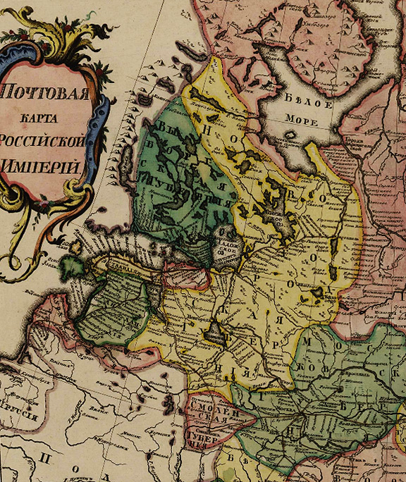
- Postal Map of the Russian Empire. I.F.Truskott, 1760
Ŵ 1-Ŵ ŴẅÑÑ 8/1
- Map Representing Inventions Created by Russan Navigators on the North Part of America with Surrounding Areas. I.F.Truskott, ŴG.F.Müller. Engraved by M.I.Makhaev, 1761
Ŵ 1-ŴḃŴẁÑ
2/12
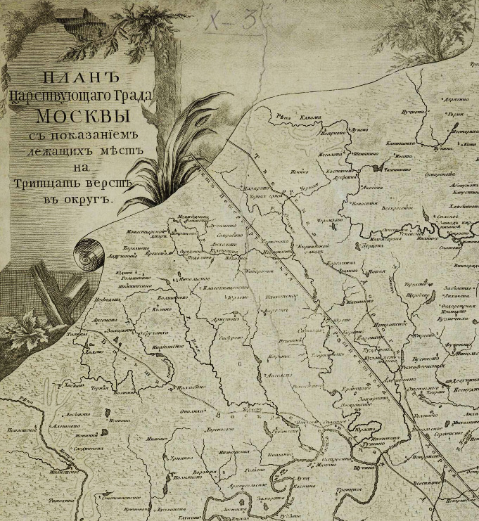
- Plan of the Capital City of Moscow with Depiction of Places Located around Thirty Versts (verst = 3500 ft.). P.T.Balabin, L.S.Terskoy, I.F.Truskott, M.I.Makhaev 1766
Ŵ 1-ŴḊÑÑ 3/16
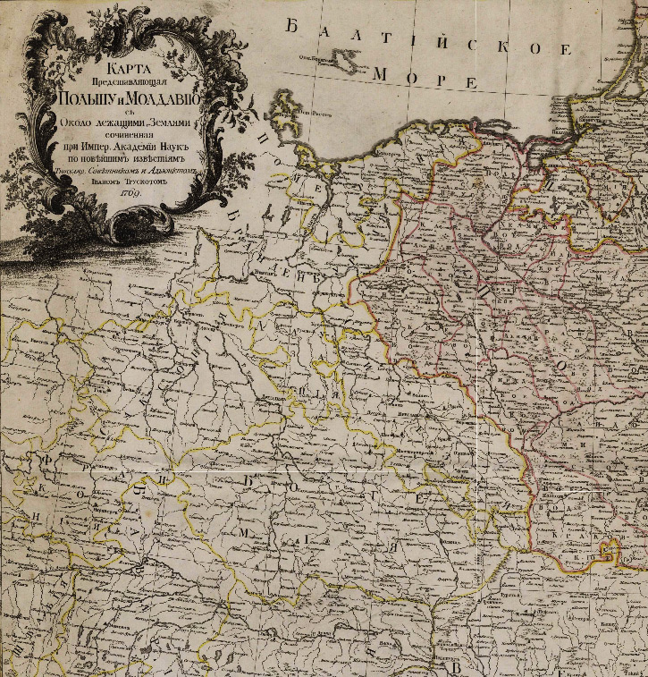
- Map Featuring Poland and Moldavia with Surrounding Lands. I.F.Truskott, 1769
Ŵ 1-Evr 4/35
- Boundary Map of the Russian and Ottoman Empires and Poland. J.F. Schmidt, 1769
Ŵ 1-Ŵ ŴẅÑÑ 4/27
- Map of Saint Petersburg Province Comprising Ingermanland, Part of Novgorod and Vyborg Provinces. Compiled by Ja.F. Schmidt in 1770. Engraved by S.Sklunov, 1770
Ŵ 1-ŴŴḞŴṡ 2/56
- New Map of the Island of Ösel Compiled with the Use of Astronomical and Geometrical Measurements Made in 1753. G.Grishov. I.F.Truskott. Engraved by K.Frolov, 1770
Ŵ 1-ŴŴḞŴṠÑŴ 2/225
- Revel Province containing the Estland Devided into Four Uyezds with the Adjacent Islands Dagõ and Vormsi. F.Schmitt. 1770. Engraved by Frolov, 1770
Ŵ 1-ŴŴḞŴṠÑŴ 2/13
- Part of Mangazeya and Yakutsk Uyezds with Mouths of the Yenisei and Lena Rivers. I.F.Truskott. Engraved by P.Kholodov, 1770
Ŵ 1-ŴŴḂŴẁŴḟ 2/8
- Map of the Nothen Part of the Russian Empire from the Mouth of the Yenisei River up to the Entry to the White Sea. I.F.Truskott. Engraved by P.Kholodov, 1772
Ŵ 1-ŴḂŴṁŴĠ 2/6
Bibliography
- O.A.Aleksandrovskaya. "Features of the Geographical Concept of M.V. Lomonosov". Issues of History of Science and Technology, 1985, No. 4, pp. 66-75;
- V.F.Gnucheva. Geography Department of the Academy of Sciences of the 18th Century. Leningrad-Moscow: Publishing House of the Academy of Sciences of the USSR, 1946, pp. 70-72;
- L.A.Goldenberg. "Geography Department of the Academy of Sciences and the Creation of the New Academic Atlas (1739-1799). / Essays on the History of Geographical Science in the USSR. Moscow, 1976, pp. 5-56, 60;
- N.E.Dik. Activities and Works of M.V.Lomonosov in the Field of Geography. Moscow, 1961, pp. 21-37;
- N.G.Fradkin "M.V. Lomonosov and his Role in the Development of Russian Geography". / Essays on the History of Geographical Science in the USSR. Moscow, 1976, pp. 61-68.
TRUSKOTT, Ivan Fomich (1719-1786) - a junior scientific assistant of the Geography Department of the St. Petersburg Academy of Sciences, an author of several well-known maps of various regions of Russia.
MÜLLER, Gerhard Friedrich(1705-1783) - a Russian historian, member of the St. Petersburg Academy of Sciences, professor.
MAKHAEV, Mikhail Ivanovich (1718-1770) - a famous Russian graphic artist and engraver.
Pochtovaya karta Rossiiskoi Imperii.
Postal Map of the Russian Empire. Compiled by I. Truskott in 1760. [G.F.Müller]. [Engraved by M.I.Makhaev]. [St. Petersburg.: Geography Department of the St. Petersburg Academy of Sciences], 1760.
1 sheet. 52x58 cm. Copper-plate engraving. Hand-coloured. The sheet is bound into the album: Collection of Maps Related to the Description of the Latest War with the Turks and Tartars in the Years 1736,1737,1738, no. IX.
Scale: [1:6 000 000, approx. 1 cm to 60 km].
(electronic resource)
The map shows the boundaries of countries and provinces, settlements, postal routes and stations, fortresses along the border between Kiev and Belgorod provinces, the Solovetsky and Uselsky on the Mezen River monasteries, Nevyansk factory in the Urals, sites of ancient settlements on the Northern Sosva River, Uluses of Kalmyk Khan, forests, and steppe vegetation, landforms. In some cases, water quality in lakes (if it is fresh or salted) are specified.
The map covers the territory of Russia from the western border to the Tobol and Ob rivers in Siberia, from the White Sea to the Caspian Sea.
The map was launched by Müller in 1754 and engraved by Makhaev in 1757. It was supposed to replace the Postal Maps of smaller scale included in different calendars. G.F. Müller pointed out the errors in the representation of coastal areas along the Caspian Sea, and the publication of the engraved map was postponed. But in 1760 it was issued. The corrected map, without the author's name and year of publication, came out, according to Müller, after his departure to Moscow.
TRUSKOTT, Ivan Fomich (1719-1786) - a junior scientific assistant of the Geography Department of the St. Petersburg Academy of Sciences, an author of several well-known maps of various regions of Russia.
MÜLLER, Gerhard Friedrich(1705-1783) - a Russian historian, member of the St. Petersburg Academy of Sciences, professor.
MAKHAEV, Mikhail Ivanovich (1718-1770) - a famous Russian graphic artist and engraver.
Karta Predstavlyayushchaya Izobreteniya Rossiiskimi Moreplavatelyami na severnoi chasti Ameriki...
Map Representing Inventions Created by Russan Navigators on the North Part of America with Surrounding Areas. Produced at the Emperial Academy of Sciences and supervised by the titular councellor Ivan Truskott. [Compiled by G.F.Müller. Engraved by M.I.Makhaev]. St. Petersburg.: Geography Department of the St. Petersburg Academy of Sciences, [1761].
1 sheet. 54x75 cm. Copper-plate engraving.
Scale: [1:14 000 000, approx. 1 cm to 140 km].
(electronic resource)
The map features the routes of the voyages by Captains Bering and Chirikov, coasts in America discovered by Gvozdev in 1730, Bering in 1741, Chirikov in 1741, Bartholomew de Fonte in 1640, Drake in 1578. Instead of the Aleutian Islands, a mythical peninsula of the North American continent is shown on the map.
Work on the map was carried out in 1753-1758 under Gerhard Friedrich Müller's supervision in response to the publication of the map by the French astronomer Joseph-Nicolas Delisle in Paris in 1752, which falsely represented the results of the Second Kamchatka Expedition and gave some inaccurate information.
BALABIN, Patrikey Timofeevich (1734/35-1788) - since 1767 an apprentice, since 1783 a master of the Engraving Chamber of the St. Petersburg Academy of Sciences.
TERSKY (Terskoy), Leo (Leonty) Grigorevich (1729-after 1773) - an engraver of the Map Making Chamber of the St. Petersburg in 1739-1753 and in 1763-1773.
TRUSKOTT, Ivan Fomich (1719-1786) - a junior scientific assistant of the Geography Department of the St. Petersburg Academy of Sciences, an author of several well-known maps of various regions of Russia.
MAKHAEV, Mikhail Ivanovich (1718-1770) â a famous Russian graphic artist and engraver.
Plan Tsarstvuyushchego Grada Moskvy...
Plan of the Capital City of Moscow with Depiction of Places Located around Thirty Versts (verst = 3500 ft.). [Balabin P.T., Terskoy L.S., Truskott I.F. ], Makhaev M.I. [St. Petersburg: the Geography Department of the Academy of Sciences, 1766].
1 sheet. 86Ñ
65 cm. Copper-plate engraving.
Scale: [1:126 000, approx. 1 cm to 1.3 km].
The plan uses conventional signs to show large and small settlements, villages, monasteries, mills.
(electronic resource)
The plan features the districts of the city of Moscow, palaces, factories, the Vaulina barren, dams, the layout of estates Izmailovo and Kuskovo, the layout of the park (?) near the settlement of Lubertsy, the Izmailovo zoological garden, settlements, roads with directions to them, barracks, agricaltural lands; forests, wetlands, landforms.
The plan contains the drawing View of the Kremlin from Zamoskvorechye District between the Kamenny (Stone) and Zhivoi (Ponton) Bridges towards the South, the title under the drawing reads: "The outline was made by M.I.Makhaev".
The plan covers environs of Moscow, including the villages of Marfino in the north and Domodedovo in the south, the settlements of Vezemets in the west and Vishnyakova in the east.
This plan is named after Lomonosov, since it was created in the period when the M.V. Lomonosov headed the Geography Department.
TRUSKOTT, Ivan Fomich (1719-1786) - a junior scientific assistant of the Geography Department of the St. Petersburg Academy of Sciences, an author of several well-known maps of various regions of Russia.
Karta Predstavlyayushchaya Pol'shu i Moldaviyu...
Map Featuring Poland and Moldavia with Surrounding Lands Compiled by the Titular Councellor and Junior Scientist Assistant Ivan Truskott at the Imperial Academy of Sciences with the Use of Recent Data in 1769. St. Petersburg: the Geography Department of the Academy of Sciences, 1769.
One sheet pasted from 2 sheets. 87Ñ
124 cm. Copper-plate engraving.
Scale: [1:1 700 000, approx. 1 cm to 17 km].
(electronic resource)
The map shows the borders of countries, lands in Germany, Moldavia and Wallachia, the European possessions of Turkey, the provinces in Russia, towns, castles, residences of Budyak and Nogai sultans, monasteries (for instance, one of Old Believers near Gomel, of Holy Cross in the Sandomierz Province, ), part of the border regions where the Zaporozhian Cossacks lived; forests, "Crooked Forest" in Belgorod Province, steppe vegetation, wetlands, landforms. The Ochakov Nogais lands are marked with inscriptions.
The map covers the PolishâLithuanian Commonwealth, Moldova, Prussia, part of the border provinces of Russia and adyacent territories of Central Europe.
SCHMIDT, yacob-Friedrich (?- 1786) - a junior scientific assistant of the Geography Department of the St. Petersburg Academy of Sciences.
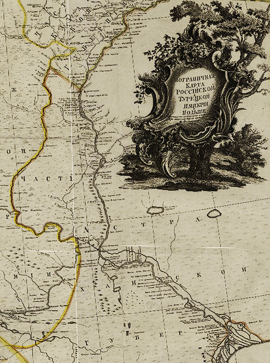
Pogranichnaya Karta Rossiiskoi i Turetskoi Imperii i Pol'shi.
Boundary Map of the Russian and Ottoman Empires and Poland. Compiled by the junior scientific assistant J.F. Schmidt at the Imperial Academy of Sciences in 1769 with the use of the recent data. [St. Petersburg: the Geography Department of the Academy of Sciences], 1769.
One sheet pasted from 2 sheets. 83Ñ
120 cm. Copper-plate engraving. Hand-coloured.
Scale: [1:1 700 000, approx. 1 cm to 17 km].
(electronic resource)
The map shows the borders of countries, provinces, regiments, populated places, post offices (with names) in the downstream part of the Volga River, fortresses, fortified lines and points, forts, mosques, residences of Budyak and Nogai sultans, fishing gangs in the downstream part of the Volga River with names of gang bosses; the Dnieper rapids, the Volga islands, steppe vegetation, forests, landforms. The territory of the Zaporozhian Host are marked on this map with regiment names.
The map represents the southen part of European Russia, covering the Crimea, Kuban and part of the Astrakhan province, as well as part of the PolishâLithuanian Commonwealth and the Ottoman Empire.
SCHMIDT, yacob-Friedrich (?- 1786) - a junior scientific assistant of the Geography Department of the St. Petersburg Academy of Sciences.
SKLUNOV, Spiridon (1751-after 1776) - a student of Makhaev at the Map Making Chamber, from 1767 to 1772 - an apprentice, since 1783 - a master of map making.
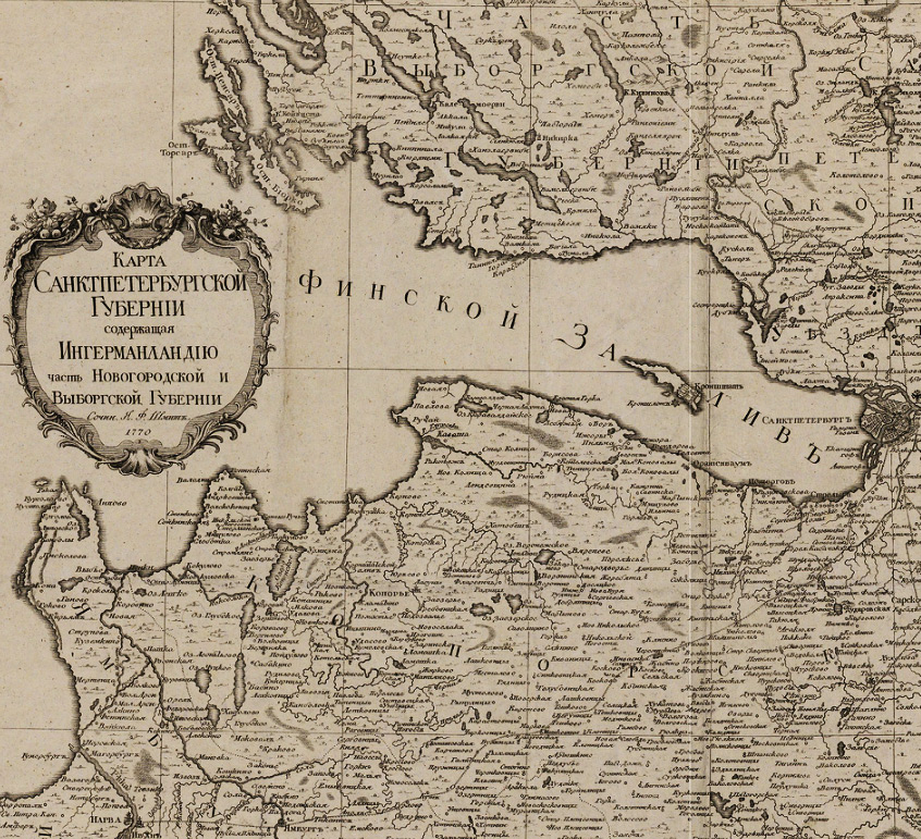
Karta Sanktpeterburgskoi Gubernii soderzhashchaya Ingermanlandiyu chast' Novgorodskoi i Vyborgskoi Gubernii.
Map of Saint Petersburg Province Comprising Ingermanland, Part of Novgorod and Vyborg Provinces. Compiled by ya.F. Schmidt in 1770. Engraved by S.Sklunov. [St. Petersburg: The Geographical Department of the Academy of Sciences], 1770.
1 sheet. 57Ñ
68 cm. Copper-plate engraving. Hand-coloured.
Scale: [1:400 000, approx. 1 cm to 4 km].
(electronic resource)
The map covers Saint Petersburg Province and bordering parts of Vyborg, Novgorod and Reval (Reval is the former name for Tallinn) Provinces.
The map shows the boundaries of provinces, uyezds (uyezd - an administrative subdivision of provinces in the Russian Empire), populated places, palaces along the coast of the Finish Gulf, "siside houses", taverns, windmills, St. Petersburg with its districts, factories, artillery barracks nearby Saint Petersburg, monasteries, Lutheran churches, pastorates, St. Peter's Chapel (in Reval Province), postal stations, roads including the projected roads St. Petersburg-Moscow and St. Petersburg-Tsarskoe Selo-Gatchina, "fishermen's yard", the Ladoga and Ligovsky Canals, vacant lands, bogs, forests, landforms.
TRUSKOTT, Ivan Fomich (1719-1786) - a junior scientific assistant of the Geography Department of the St. Petersburg Academy of Sciences, an author of several well-known maps of various regions of Russia.
FROLOV, Konstantin - a map engraver.
GRISHOV, Augustine-Nathaniel (1726-1760) - a professor of astronomy, a conference secretary of the St.Petersburg Academy of Sciences in 1751-1754.
Novaya Karta Ostrova Ezelya sochinennaya po Astronomicheskim nablyudeniyam i Geometricheskim izmereniyam...
New Map of the Island of Ösel Compiled with the Use of Astronomical and Geometrical Measurements Made in 1753 by Mr. Grishov. Through the efforts of J. Truskott. 1770. Engraved by Frolov. [St. Petersburg: The Geographical Department of the Academy of Sciences], 1770.
1 sheet. 54x76 cm. Copper-plate engraving. Hand-coloured.
Scale: [1:250 000 approx. 2.5 km in 1 cm].
(electronic resource)
The map shows settlements, the fortress of Arensburg (now known as Kuressaare), Lutheran churches with their names, water mills, a lighthouse, roads, islands, shoals, forests, wetlands, landforms.
Map covers the Island of Ösel (the modern name for it is the island of Saaremaa) and Moon (the modern name is Muhu) in the Baltic Sea with the adyacent areas of the island of Dagõ (the modern name is Hiiumaa) and Estland.
SCHMIDT, yacob-Friedrich (?- 1786) - a junior scientific assistant of the Geography Department of the St. Petersburg Academy of Sciences.
FROLOV, Konstantin - a map engraver.
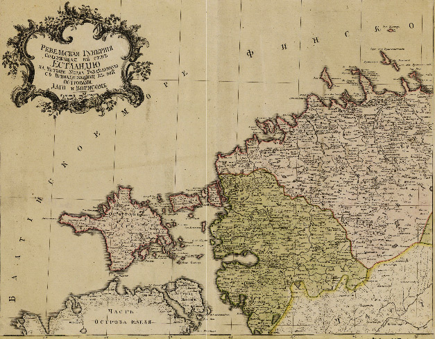
Revel'skaya Guberniya Soderzhashchaya v sebe Estlandiyu na Chetyre Uezda Razdelennuyu s Prilezhashchimi k nej Ostrovami Dago i Vormsom.
Revel Province containing the Estland Devided into Four Uyezds with the Adyacent Islands Dagõ and Vormsi. Compiled by J. F. Schmitt. 1770. Engraved by Frolov. [St.-Petersburg.: Department of Geography Sciences], 1770.
2 sheets in a common frame. 56x64 cm; 55x65 cm. Copper-plate engraving. Hand-coloured.
Scale: [1:350 000, approx. 3.5 km in 1 cm].
(electronic resource)
The map covers Revel (Revel is now known as Tallinn) Province with a portion of Livonia.
The map shows the boundaries of provinces, uyezds (uyezd - an administrative subdivision of provinces in the Russian Empire), populated places (the settlements of fishermen are marked), Catholic and Lutheran churches with their names, pastorates, the St. Bridget's Convent, a brick factory (near Revel), a glass factory (in Virland Uyezd), the forester's house, a mill, a post office and chapel, lighthouses, a ferry between the Island of Ösel (the modern name for it is the island of Saaremaa) and the island of Dagõ (the modern name is the island of Hiiumaa); forests.
TRUSKOTT, Ivan Fomich (1719-1786) - a junior scientific assistant of the Geography Department of the St. Petersburg Academy of Sciences, an author of several well-known maps of various regions of Russia.
KHOLODOV, Prokhor Rodionovich (1738/40-1815) - an engraver, map master at the St. Petersburg Academy of Sciences.
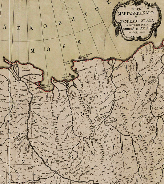
Chast' Mangazeiskago i Yakutskago Uezda s ust'yami rek Enisei i Leny.
Part of Mangazeya and Yakutsk Uyezds with Mouths of the Yenisei and Lena Rivers. Compiled by I. Truskott. 1770. Engraved by P.Kholodov. [St. Petersburg: the Geography Department of the Academy of Sciences], 1770.
1 sheet. 56Ñ
67 cm. Copper-plate engraving. Hand-coloured.
Scale: [1:4 800 000, approx. 1 cm to 48 km].
(electronic resource)
The map shows the boundaries of provinces, uyezds (uyezd - an administrative subdivision of provinces in the Russian Empire), populated places, winter cabins, monasteries; marsh area between the Lower Tunguska and the Stony Tunguska Rivers, forests, tundra vegetation, rapids in the upstream part of the Kolyma River, landforms. Territories, where ethnic groups lived, are marked with inscriptions.
TRUSKOTT, Ivan Fomich (1719-1786) - a junior scientific assistant of the Geography Department of the St. Petersburg Academy of Sciences, an author of several well-known maps of various regions of Russia.
KHOLODOV, Prokhor Rodionovich (1738/40-1815) - an engraver, map master at the St. Petersburg Academy of Sciences.
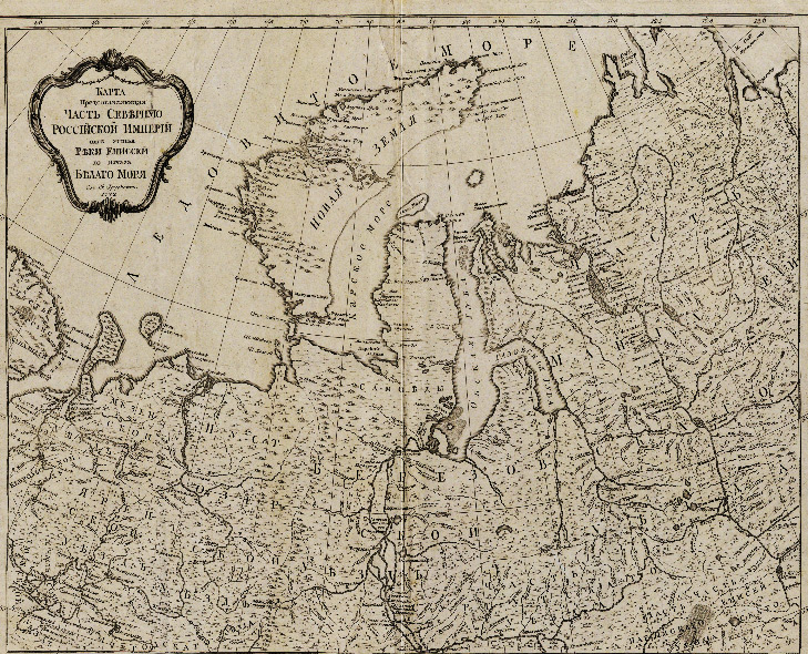
Karta Predstavlyayushchaya Chast' Severnuyu Rossijskoi Imperii ot ust'ya Reki Enissey do Nachala Belago morya.
Map of the Nothen Part of the Russian Empire from the Mouth of the Yenisei River up to the Entry to the White Sea. Compiled by I. Truskott. 1772. Engraved by P.Kholodov. [St. Petersburg: the Geography Department of the Academy of Sciences], 1772.
1 sheet. 58Ñ
68 cm. Copper-plate engraving.
Scale: [1:4 500 000, approx. 1 cm to 45 km].
(electronic resource)
The map shows the boundaries of uyezds (uyezd - an administrative subdivision of provinces in the Russian Empire), populated places, including the sites of ancient settlements, winter abodes along the Yenisei and Khatanga Rivers, Holy Trinity Monastery and "Golubin's shops" on the Yenisei River, winter cabins built by Dutch ships' crew in 1596 on the shore of Novaya Zemlya; shoals in the Ob Bay, the deer wade through the Ob Bay, tundra vegetation, forests, landforms. The geographical distribution of Samoyedic peoples are marked with inscriptions.
Map covers the territory of Mezen, Mangazeya, Berezov, Pustozersk, Yarensk uyezds with adyacent parts of neighboring uyezds.