It was established on 1 August 1927 as a result of the administrative and territorial reform. The oblast was historically preceded by Ingermandland Province which was created in 1708 and renamed later Saint-Petersburg, (Petrograd, Leningrad) Province.
The most ancient population inhabited the land corresponding to the territories of present-day Leningrad Region after the retreat of glaciers in the ninthâeighth milleniums BC. By the middle of the first millenium AC, settled Finno-Ugric tribes already lived here, they were engaged in farming, cattle-breeding, hunting and fishing. Slavs have populated this territory since the eighth century.
The city of Ladoga (from the eighteenth century Staraya Ladoga), one of the earliest Russian settlements, was founded in the 750s. During the ninthâtenth centuries Ladoga was the most important political and economical center for forming of State system of Old Russia. It lost importance only at the close of the tenth century, and gave place to Novgorod.
In the twelfth century, Novgorod gained political independence, and territories along the Gulf of Finland, the Lake Ladoga, the Luga, Neva and Volkhov rivers became parts of Novgorod Lands. During the thirteenth-fourteenth centuries, these lands were the scene of the fight against an enemy invasion of Livonian Knights and Swedish feudal lords. In 1240, the confluence of the Neva and Izhora rivers was the site of the celebrated Battle of the Neva, when Russian army under the command of Alexander (Nevsky), Prince of Novgorod, defeated Swedish invaders. During the thirteenth-fourteenth centuries, the people of Novgorod built the fortresses of Jama, Koporye, Oreshek ("Nutlet"), Korela, Tiversk to protect Russia against attack from the northwest.
During some of the most trying times in the country's history at the turn of the seventeenth century known as the Time of Troubles, Sweden captured Northwest Russia and barred the country's way to the Baltic Sea. In the early 1700s, after the victory of Russians under Peter the Great over Swedish army in the Great Northern War, the territory of the oblast was reconquered by Russia. Saint Petersburg, the new capital of the country, was founded here in 1703.
In 2007, an exibition, organised in celebration for eighty years of the establishment of Leningrad Region, took place at the Smolny Cathedral in Saint Petersburg. Its cartographic part is available online now. On display are maps of this historical region of Russia dating back to the sixteenth century. The maps represent many place names and make it possible to trace the centuries-old history of the development of the area.
Ladoga Canal. Canalis Ladogenis nova Delineatio secundum exemplar Petropolitanum aeri incidit Matthaeus Seutter, Sac. Caes. Maj. Georg. Aug.V. Cum Priv.Sumi Vicariat in part Rheni, Franc. et Seuv. juris. [Augsburg, 1740-1750s].
Scale approximately: 1:150 000.
Oriented: North-west.
1 pl. 48Ñ
57 cm. Copperplate engraving. Hand-Coloured.
With the parallel Latin title. Scales, place names are written in Latin letters parallel to the Cyrillic alphabet.
The same in Russian. Ladoga Canal. J. Grimel del. [The cartouche was engraved by J.E. Grimmel. St.-Petersburg: The Geographical Department of the Academy of Sciences, before 1742].
(electronic version)
The map shows the boundary between Ingermanland and Novgorod Province, settlements (indicated by individual buildings, some structures are with a cross), fortresses including Shlisselburg, a palace on the coast of Lake Ladoga at mouth of the Kobona Riva, the St. Nicholas' Monastery, a windmill, roads, two glades running away from the canal, the sluices at mouth of the Kobona Riva, the Ladoga Canal, agricultural lands; meadow vegetation, forests, marshes, coastal shoals, relief features.
The title of the map is displayed within a decorative cartouche depicting figures of Athena and Mars, measuring tools, a globe, military attributes, a sluice.
In 1741 - 1742 a topographic map series of the territories adjoining the City of Saint Petersburg. This series is remarkable for the fact that the Ladoga Canal was represented on the maps for the first time. Navigation on the rough Lake Ladoga was rather dangerous, and so Peter the Great made the decision to construct the canal around of Lake Ladoga, from the Volkhov Riva to the Neva. Its construction began in May 1719, and in 1731 the canal was opened for navigation.
As a result of strong interest in Russia during the Era of Peter the Great, the map series of the area around Saint Petersburg was subsequently re-issued by European publishers. Present map was engraved and published by the publishing firm of Matteus Seutter in Augsburg.
Lake Ladoga and the Gulf of Finland with the Surrounding Area. Consspectus recens et accuratus magnae partis Lacus Ladogae et Sinus Finnici cum interjacentibus ad exemplar Petropolitanum in aes incidit Matthaeus Seutter, S.C.M.G. Aug.V.Cum Priv.Sumi Vicariat. in part Rhen:Suev:et Franc:Juris.
Augsburg, [1740-1750s].
Scale approximately: 1:84 000.
Compass points are drawn on the area of Lake Ladoga.
1 pl. 49Ñ
56 cm. Copperplate engraving. Hand-Coloured.
Part of the title, explanatory notes are both in Latin and Russian; part of the title are written in Latin letters parallel to the Cyrillic alphabet. (electronic version)
It is a map of the territory from Kronstadt to New Ladoga, comprising parts of Karelia, Ingermanland and Novgorod Provinces.
The map shows boundaries of provinces, populated places (some of which are indicated by buildings), monasteries, subdivisions of districts (pogosty), fortresses, "seaside houses" along the south coast of the Gulf of Finland, palaces, individual buildings, estates, a tavern near the settlement of Mga, a "poor house" located in the upstream part of the Neva River, the Galley Harbour in Saint Petersburg, the Ladoga Canal.
Outposts of Jama, Vologoda and Smolensk are also shown. The map depicts the Sinyavin battalion; roads, a watermill on the Naziya River, factories, a quarry on the Tosna River, agricultural lands; shandbanks, swamps, forests. The "Shungur Hills" (Duderhof Hills) are also recorded.
The title of the map against a background of a panel is within a decorative cartouche depicting Neptune with a trident and naiads with urns.
The map was engraved by the publishing firm of Matteus Seutter in Augsburg. It is a slightly altered replica of the map, compiled by the Petersburg Academy of Sciences in 1741-1742.
Nova et accurata delineatio Ingriae et Careliae cum magnna parte Sinus Finnici et hacus Ladogae, mec non Inssularum adjacentium Aeri incidit et excudit Matthaceus Seutter, S. Caes. Maj. Geogr. Aug. Vind. Cum Gratia et Privilegio S.R.Vicariatus in partileg Rheni, Franconici et Sveviae Juris. Matthaeus Seutter. [Augsburg, 1740-1750s].
Scale approximately: 1:590 000.
Compass points are drawn on the area of Lake Ladoga.
1 pl. 54Ñ
47 cm. Copperplate engraving. Hand-Coloured.
In Latin.
(electronic version)
It is a map of the area covering Ingermanland and Karelia.
The map shows administratve boundaries, populated places, Saint Petersburg with built-up quarters, "seaside houses" along the south coast of the Gulf of Finland, field fortifications, monasteries, factories, taverns, a quarry, a major road from Saint Petersburg to Moscow, a road from Saint Petersburg to Tsarskoe Selo (Tsar's Village), the Ladoga Canal, forests, marshes.
The title of the map is within a decorative cartouche containing the coat of arms of the Russian Empire, topped with a crown, and seven coats of arms of individual regions of the country. The cartouche also has images of Mars, Jupiter, Glory, a globe, military attributes.
The map was engraved by the publishing firm of Matteus Seutter in Augsburg. It is a slightly altered replica of the map, compiled by the Petersburg Academy of Sciences in 1741-1742, with a different cartouche.
Polozhenie mest mezhdu gorodom Arkhangelskim Sankpeterburgom i Vologdoiu.
Locations of Places between the Town of Arkhangelsk, Saint Petersburg and Vologda. [Saint Petersburg: the Geographical Department of the Academy of Sciences, 1745].
Scale approximately: 1:1 500 000.
1 pl. 47Ñ
53 cm. Copperplate engraving. Hand-Coloured.
(electronic version)
The map represents Karelia and Ingermanland, including Kargopol, Olonets, Keksholm, Novgorod, Vologda, and Vaga districts, as well as Zaozersky, Sutskoi and Nadporozhsky stans (subdivisions of districts).
The map shows administratve boundaries, populated places, fortresses, monasteries, a postal station at the border between Dvina and Kargopol districts, a road from Saint Petersburg to Moscow, saltworks located in the downstream part of the Onega River, a "shop" on the Yavai Peninsula, mills, anchorages on the Baltic Sea, the Ladoga Canal, "Birichevsky Rapids" on the Onega River, forests.
The title of the map is displayed within a decorative cartouche with an image of the Greek goddess of victory and triumph Nike and a female figure with a horn of plenty.
The map was included in the Atlas Rossiiskoi, comprising nineteenth specially-made maps representing the whole Russian EmpireâḊ composed in keeping with the rules of geography and the most recent observations, with a supllementary General Map of this Great Empire. Produced through the efforts and labours of the Imperial Academy of Scienes.
This is the first Russian atlas to cover the entire territory of the Russian Empire. It was produced in the Geographical Department of the Academy of Sciences in Saint Petersburg on the basis of instrument state surveys carried out since 1719, taking into account the discoveries of a number of expeditions, including Bering's and Spanberg's.
The atlas took almost 20 years to compile. In 1745 it was published in Russian, German, Latin and French. This map was re-issued several times, with relevant additions and alterations, up until 1762.
Karta Sanktpeterburgskoi Gubernii soderzhashchaya Ingermanlandiyu chast' Novgorodskoi i Vyborgskoi Gubernii
Map of Saint Petersburg Province Comprising Ingermanland, Part of Novgorod and Vyborg Provinces. Compiled by Ja.F. Schmidt in 1770. Engraved by S.Sklunov. [St. Petersburg: The Geographical Department of the Academy of Sciences], 1770.
Scale approximately: 1:380 000.
1 pl. 44Ñ
56 cm. Copperplate engraving.
Map of St. Petersburg Province with the Bordering Parts of Vyborg, Novgorod and Revel Provinces.
(electronic version)
The map covers Saint Petersburg Province and the bordering parts of Vyborg, Novgorod and Reval (the German name for Tallinn) Provinces.
The map shows administratve boundaries, populated places, palaces along the coast of the Gulf of Finland, "siside houses", taverns, windmills, factories, artillery quarters nearby Saint Petersburg, subdivisions of districts (pogosty), monasteries, Lutheran churches, pastorates, St. Peter's Chapel (in Reval Province), postal stations, roads, the Ladoga and Ligovsky Canals, vacant lands, marshes, forests.
The title of the map is displayed within a decorative cartouche with garlands of leaves, flowers, and fruit.
The map was compiled by the junior scientific assistant Jacob Schmidt at the Geographical Department of the Academy of Sciences in Saint Petersburg. The Geographical Department of the Academy of Sciences (1739-1798) is a geographical and cartographical establishment, founded in order to speed up the development of map-making in Russia.
Throughout the period of its existence, the Geographical Department published the Atlas of the Russian Empire, as well as, about 300 maps, including general maps of the Russian Empire (1776 and 1786), maps of provinces and parts of Russia, based on materials of academical expeditions to different regions of the country.
Karta St. Peterburgskoi gubernii.
Map of St. Petersburg Province. Compiled by Ŵlexander Vil'brekht. Engraved by Alexei Savinkov. [Engraver of the cartouche is] G. Kharitonov. [Saint Petersburg: the Geographical Department of the Cabinet, the Mining Academy's engineering school, 1792].
Scale approximately: [1:760 000].
1pl. 46Ñ
57 cm.
Copperplate engraving. Hand-Coloured borders.
(electronic version)
The map shows borders of provinces and disricts, populated places, fishermen's houses along the coast of Lake Ladoga, fortresses, monasteries, factories, windmills, the Ladoga and Syas Canals; forests, and marshs.
The map is decorated with a subject decorative cartouche, featuring allegorical images: the goddess Athena is depicted with a ceptre in the foreground; Mercury with an unrolled scroll is on bended knees before her; next to him is a globe, books, a palette and brushes. Symbols of the Tsar's power are on a support; triumphal gates are to the left of the pyramid; on a pediment is an allegory of the victories over Sweden - a chained lion, a banner with the coat of arms of Sweden, tilted down in dishonour, and military attributes; above them is a soaring double-headed eagle with lightnings of Jupiter; in the opening of the gates is the figure of the Bronze Horseman (a monument to Peter the Great); in the background are sailing boats.
The cartouche symbolizes the successes of Catherine's rule and the importance of St. Petersburg as the state capital, the residence of Emperors, a trading and port city, and a center for science and culture.
The map was included in the Geographical Atlas of the Russian Empire (Rossiiskoi atlas izsoroka chetyrekh kart sostoyashchii i na sorok na dva namestnichestva, imperiyu razdelyayushchii), compiled by Ŵ. Vil'brekht and published in Saint Petersburg in 1792. After the Academy's Atlas of 1745, it is the second largest desktop reference atlas. It represents the administrative structure of the Russian Empire, established from the New Regulations on Provinces of 1775.
The atlas provides information about the density and character of populated places, about the extraction of mineral versions, about vegetation, with sub-divisions into deciduous, mixed, and evergreen forests and shrubs. In some cases, waterways are indicated down to small streams. Marshes are shown. Roads are not included. Each plate is embellished with a subject cartouche, illustrating the main occupations of the population of the represented area.
Karta Okruzhnosti St. Peterburga.
Map of Environs of Saint Petersburg. Compiled by Ŵ.Vil'brekht. Engraved by G.Kharitonov and A.Savinkov. [Saint Petersburg: The Geographic Department of the Cabinet of Her Imperial Majesty, the Mining Academy's engineering school, 1796-1800]
Scale approximately: 1:190 000.
1 pl. 44Ñ
56 cm. Copperplate engraving.
(electronic version)
The map represents the area around the Saint Petersburg comprising the teritory from the island of Kotlin to the Sheldikha River.
The map depicts boundaries of districts, populated places, country houses on the south coast of the Gulf of Finland, palaces, fortresses, ensembles of palaces and parks, St. Sergius Cloister, Lutheran churches, roads, a parsonic house on the road to Vyborg, a tavern on the road located in the upstream part of the Okhta River, camps on the north coast of the Gulf of Finland. Faience factories, textile and paper mills, iron foundries, brass and powder works, ceramic and glass works, sawing mills, wineries are shown. The map also contains quarries, the Ladoga and Ligovsky Canals, agricultural lands, parks; sandbanks, rocks and reefs, swamps (with indication of its passability), deciduous and mixed forests, shrubs.
The title of the map is displayed within a decorative cartouche showing the crowned double-headed eagle with an olive branch and wreath.
The Map of Environs of Saint Petersburg depicts design layout of the capital within city limits of the mid-1790s, idicating enlarged blocks of buildings, major streets, canals and ditches that ran along city limits. The map is characterised by an essential trait: it portrays relief features, valleys of rivers, batter lines. This detailed map much more accurately, than it was in the mid-eighteenth century, shows the Neva River and its tributaries, canals, many large and small rivers, lakes, sandbanks and navigation channels in the Gulf of Finland. Such combination of topographic and hydrographic features allows to regard this map as a positive and important concluding result of activities of capital topographer and hydrographer over the period of the whole eighteenth century.
The map was compiled by Ŵlexander Vil'brekht, a mathematician, geographer, cartographer, astronomer; the head geographer of the Geographic Department of the Cabinet of Her Imperial Majesty (from 1786), a teacher of the Mining Academy's engineering school, an associat member of the Academy of Sciences.
The Geographic Department of the Cabinet of Her Imperial Majesty (1786-1800) was an cartographic institution, established under the Cabinet of Her Imperial Majesty Catherine the Great to centralise map making in the country under a high-level state body. In 1800 it became a part of His Majesty's Own Map Deport.
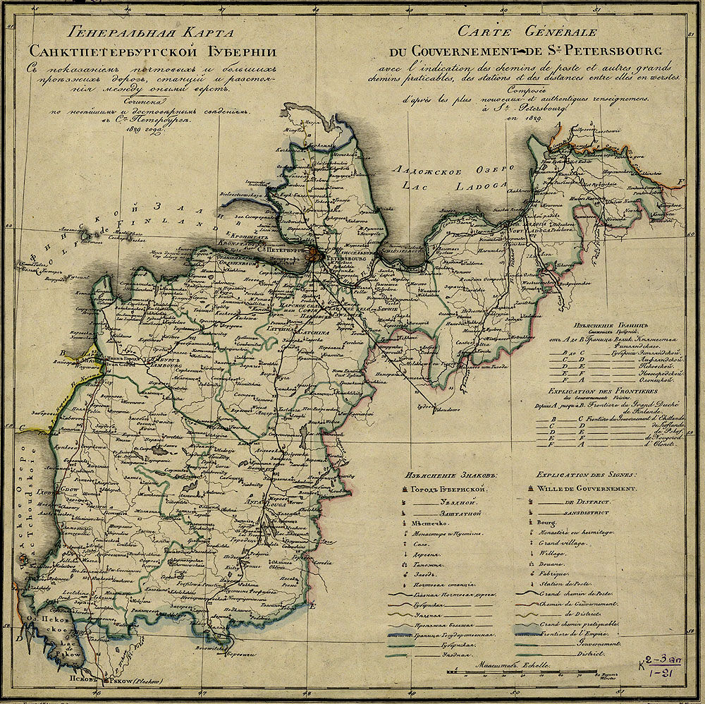
General'naya karta Sanktpeterburgskoi gubernii s pokazaniem pochtovykh i bol'shikh proezzhikh dorog, stantsii irazstoianiya mezhdu onymi verst.
General Map of Saint Petersburg Province Showing Postal Roads and Large Highways, Stations and Distances between them in Versts (verst = 3500 ft.). Compiled on the Basis of Recent and Reliable Data at Saint Petesburg in 1829.= Carte Generale du Gouvernement de St. Petersbourg avec l'indication des chemins praticables, des tations et des distances entre elles en werstes. Composee d'apres les plus nowoceaux et authentiques renseignemens a St. Petersbourg en 1829. Compiled and Engraved by Piadyshev. Text is Engraved by M.Ivanov. Saint Petersburg, 1829.
Scale approximately: 1:1 092 000.
1 pl. 34Ñ
34 cm. Lithograph. Hand-Coloured.
With the parallel French title, conventional signs and place names.
(electronic version)
The map shows administrative boundaries of 3 types, populated places (6 groups), monasteries and cloisters, custom houses, factories, postal stations, postal roads of 3 types and large highways.
The map was a part of the Atlas of the Russian Empire, the Kingdom of Poland and the Grand Duchy of Finland (Atlas Rossiiskoi Imperii, Tsarstva Pol'skogo i Velikogo kniazhestva Finliandskogo) compiled by Colonel V.Piadyshev (1758 - 1835).
(ÑŴṠ. ÑŴṁÑÑÑÑ)
Piadyshev worked for the Military Topographic Depot, since 1820 he was Assistant Department Head for Engraving and Map-Printing. He was responsible for marking road distances on maps on the basis of diverse books of roads. As data provided in these books were not complete, Piadyshev himself produced Guidebook to the entire Russian Empire and the Kingdom of Poland (Saint Petersburg, 1818).
In addition to the guidebook, Piadyshev compiled road maps for each province at a large scale, which were included in the Atlas of the Russian Empire, the Kingdom of Poland and the Grand Duchy of Finland.
In preparing the compilation of the maps he used materials of topographical and land boundary surveys.
Topograficheskaya karta Sanktpeterburgskoi gubernii.
Topographical Map of St. Petersburg Province. Compiled at the Scale of 1:210,000 on the Basis of Major-General Fedor Schubert' Survey and Engraved at the Military Topographic Depot. Engraved by Several Hands. [Saint Petersburg], 1834.
Scale approximately: 1:210 000.
8 pl., 1 set of preliminary pages. 45Ñ
59 cm. Copperplate engraving.
(electronic version)
The map shows district boundaries, settlements (to individual homestead inclusive). A number of homesteads in villages are also recorded. Roads are indicated down to small country- and winter tracks. The map contains railways with stations, postal stations, monasteries, works and factories, mills of three types (watermills, windmills, animal mills) , telegraph offices, lighthouses, forests, shrubs, marshes.
The map was compiled by cartographers from the Military Topographic Depot under the direction of Major-General Fedor Schubert. It was one of the most accurate maps of Saint-Petersburg Province for those days. Fedor Schubert (1789-1865) was a noted Russian land-surveyor and map-maker, the head of the Military Topographic Depot of the General Staff, the founder and commander of Russian military topography corps, a honorary member of the Petersburg Academy of Sciences.
He was the chief surveyor for trigonometrical and topographical surveys carried out in quite a number of provinces. Schubert compiled and published the Treatise on calculus of trigonometrical surveys and works of the Military Topographic Depot (1858). All cartographic works by Fedor Schubert are of great importance. Especially noteworthy among them are the ten-verst (verst = 3500 ft.) special map of Western Russia (1811-1841) printed in 60 sheets and known as Schubert's map, as well as his works devoted to the study of the Earth's shape and size.
Ethnographische karte des St. Petersburgischen Gouvernements, angefertigt und erläutert vom Akademker, Dr P. v. Koeppen. Herasgegeben. von der Akademie der Wissenschaften zu St. Petersburg, 1849.
Ethnographical Map of St. Petersburg Province Compiled by Petr Keppen.
Scale approximately: 1:630 000.
1 pl. 34Ñ
60 cm. Copperplate engraving. Hand-Coloured.
(electronic version)
The map depicts the territories inhabited by Germans and Finnic peoples, including Votes, Izhorians, Ayramoisets (came from Ayrapaa nearby Viborg), Savakots (came from Savo); Estonians, Karelians. Borders of provinces are shown.
The Map was compiled by the Russian scientist, statistician, ethnographer Petr Keppen (1793-1864), who was one of founders of the Russian Geographical Society. He was the head of the Department of Statistics at the Society and systematicly collected data on the ethnic composition of the population of Russia. He published the first Ethnographical Map of European Russia (1851) and compiled the "Chronological Index of Materials for the History of Small Ethnic Groups of European Russia" (1861).
Karta promyshlennosti S.Peterburgskoi gubernii 1853.
Map of the Industry of Saint Petersburg Province 1853. Copiled by N. Overchenko. Saint Petersburg, A.Transchel's Lithographic Press, [1854].
Scale approximately: 1:840 000.
1 pl. 37Ñ
45 cm. Lithograph. Hand-Coloured.
The map shows boundaries of provinces and districts, populated places, roads, canals, navigable and floatable rives, wharfs, rapids, flagstone and limestone quarries, works and factories.
The map represents 116 works and fabrics. It is noteworthy that a clear majority of industrial enterprises in Petersburg district are metal working (five plants), paper (eight mills) and textile (six mills); the wine industry (twelve distilleries) prevails in Yamburg district; most of factories (five) in Luga district are glassware, mainly, bottle; the paper industry predominates in Peterhof district (seven mills); a large number of saw mills (five) are shown in Tsar's Selo district.
Geognosticheskaya karta S. Peterburgskoi gubernii.
Geognostic Map Saint Petersburg Province. Compiled in 1866 and 1867 by I. Bok. [S.l., 1867?].
Scale approximately: 1:840 000
1 pl. 37Ñ
49 cm. ŴḂolour lithograph.
(electronic version)
The map depicts boundaries of provinces and districts, populated places (6 groups), railways, mail and unpaved roads, marshes (some are named or have the nature of the vegetation).
This is one of the first geological maps of Saint Petersburg Province. Different colours are used to show layers of the Early Silurian and Devonian Systems. Rocks and petrifactions of these systems are given in Russian and Latin in a table. The map was compiled by Ivan Bok (1844 - 1916), a geologist and statistician. He also created a number of works, including the "Geognostic Desciption of the Early Silurian and Devonian Systems of Saint Petersburg Province" (1868); "Materials for Statistics on Manufactory and Factory Industry in European Russia for 1868" (1872); "About Water Supply for Saint Petersburg" (1894).
Plan mestnosti zanimaemoi nyne S-Petersburgom, sniatyi v 1698 g.
Map of the Territory now Occupied by Saint Petersburg, Made in 1698. Architect E.V.Schwartz. [Saint Petersburg: Ŵ. Ilyin's Cartographic Establishment, 1872].
Scale approximately: 1:50 400.
1 pl. 22Ñ
27 cm. Lithograph.
(electronic version)
1 ŴṠ. 22Ñ
27 ÑŴỳ. ŴŴẁÑŴẅŴġÑŴḞÑŴẁÑ.
In 1698, the commandant of the fortress of Nyenschantz, Swedish baron Avraam Cronjort made a map showing the Neva delta. In five years after that Saint Petersburg was founded.
In 1737 the map was revised by Ch.J. Schwartz employed at the Academy of Sciences in Petersburg. The Russian version was prepared by architect R.E. Schwartz in 1872 and published at A. Ilyin's Cartographic Establishment.
The map depicts the territory around the Neva delta as a rather abandoned area that does not reflect reality. Walls of the fortress and surrounding buildings are shown as the main objects.
The cardinal event, preceding the foundation of new capital, was the seizure of this fortress by Russian army during the Great Northern War. Later its fortifications were destroyed to the ground.
In 2000 a memorial sign was erected on the site of the fortress.
Etnograficheskaya karta S.Peterburgskoi gubernii
Ethnographical Map of St. Petersburg Province. S.l., [the second half of the 19th cent.?].
1 pl. 31Ñ
43 cm. Lithograph. Hand-Coloured.
Scale approximately: 1:1 000 000.
(electronic version)
The map depicts the territories inhabited by Germans and Finnic peoples, including Votes, Izhorians, Ayramoisets (came from Ayrapaa nearby Viborg), Savakots (came from Savo); Estonians, Karelians. Borders of provinces are shown.
The Ethnographical Map of St. Petersburg Province by Petr Keppen was probably used in the compilation of this map.
Karta S.Peterburgskoi gubernii.
Map of St. Petersburg Province. St. Petersburg, A. Ilyin's Cartographic Establishment, [1897-1906?].
1 pl. 38Ñ
50 cm.
Hand-Coloured borders.
Lithograph.
Scale: 1:840 000.
A supllementary map: St. Petersburg. Scale: 1:84 000.
(electronic version)
The map shows administratve boundaries from provinces to districts, populated places, roads, postal stations, marshes.
A. Ilyin's Cartographic Establishment, founded in 1859, was Russia's leading civilian enterprise in the field of cartography before the Revolution. It issued numerous basic atlases of the world and Russia, thematic maps, educational maps and atlases. The Establishment still exists today.
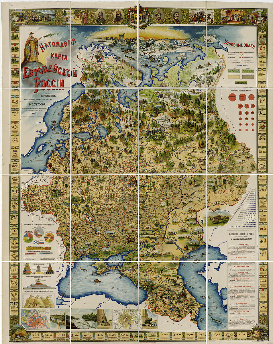
Nagliadnaia karta Evropeiskoi Rossii.
Pictorial Map of European Russia. Compiled by M. Tomasik. Supplemented and Published by Teachers' Society under the Editorship of V. Urusov. Warsaw, Samuel Orgelbrand's Joint-stock Company, 1903.
Scale approximately: 1:2 100 000
1 pl. 204 Ñ
160 cm. ŴḂolour lithograph.
(electronic version)
The map is an attempt to create an integrated educational material on Russia's geography for school children, covering objects of nature, animals, vegetables, peoples living in Russia, and main trades of local inhabitants. These all are represented on the same map. Compilers carried out an experiment to study Russia's geography as the unity of the natural environment and a man.
The map was awarded a prize in 1896 at the All-Russian Exhibition in Nizhny Novgorod. In 1903 it was re-issued.
The map is supplemented with the Pictorial Map of European Russia that includes guidelines for the use of the map, an alphabetical list of pictures on the map, and an alphabetical list of coats of arms of European Russia's provinces.
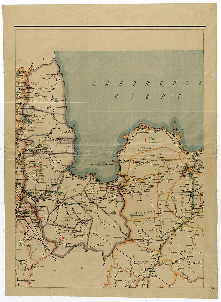
Karta Petrogradskoi gubernii.
Map of Petrograd Province. Compiled by the Evaluation Department of the Petrograd Provincial Government Council. Petrograd: Petrograd Provincial Council (Zemstvo), A. Ilyin's Cartographic Establishment, 1916.
Scale approximately: 1:210 000.
7 pl. placed in a common frame of 52Ñ
71 cm. ŴḂolour lithograph.
(electronic version)
The map shows boundaries of provincial districts and their subdivisions (volosts), roads, schools (9 groups), medical institutions (10 groups), summer housing estates and country places, telephone exchanges, churches, including Protestant ones and prayerful houses.
It includes a list of volosts by district.
The detailed mapŴṁ clearly demonstrates the great organization work of Petrograd provincial and district government councils on the establishment of schools and medical institutions.
A. Ilyin's Cartographic Establishment, founded in 1859, was Russia's leading civilian enterprise in the field of cartography before the Revolution. It issued numerous basic atlases of the world and Russia, thematic maps, educational maps and atlases. The Establishment still exists today.
Naselenie. Vaesto. Population. Leaves 1-2. The Population Density of Leningrad Oblast. Compiled by the Geographic Economic Research Institution under the editorship of the Leningrad Oblastal Planning Committee. [Leningrad: the Geographic Economic Research Institution, 1934].
Scale: 1:1 000 000
2 sh. 71 Ñ
38 cm, folded to 46 Ñ
38 cm. ŴḂolour lithograph.
Titles of maps in the Atlas are written in Finish and English parallel to Russian.
The map Population consists of two sheets (the northern and southern parts of Leningrad Oblast). It mainly shows the population density (the number of peoples over area of land measured in km2).
A majority of population is concentrated in Leningrad Oblast, as well as along rivers. Nevertheless, unsettled lands are even to be found in the immediate environs of Leningrad .
The supplementary map Ethnic Composition of Leningrad Oblast and the Karelian Autonomous Soviet Socialist Republic (Karelian ASSR) is also presented to the view. In contrast to Ethnographic Map by Petr Keppen, this map represents much more ethnic groups, including Russians, Letts, Saami and Kvens, Veps and Chuhari. Nomad camps of Lapps, Nenetses, Izhems are also marked.
The same sheet also contains:
- a diagram that illustrates the distribution of various age groups in Leningrad Oblast. It is evident that most of able-bodied adults (who are between the ages of 16 and 59) inhabit cities and towns. The rural residents are mainly persons of other age groups.
- a cartogram that displays the numbers of people living in urban and rural areas in Leningrad Oblast by district and the population densities by district.
The map was included in the Atlas of Leningrad Oblast and the Karelian ASSR. Leningrad: the Geographic Economic Research Institution, 1934. P.4-5.
The atlas is provided with accompanying text and an alphabetical index.
Promyshlennost'. Teollisuus. Industry. Leaf 2. The Sectoral Structure of the Industry of Leningrad Oblast in 1932. Compiled by the Geographic Economic Research Institution under the editorship of the Leningrad Oblastal Planning Committee. [Leningrad: the Geographic Economic Research Institution, 1934].
Scale: 1:1 750 000
1 sh. (2 maps) 34 Ñ
38 ÑŴỳ, folded to 46 Ñ
38 cm. ŴḂolour lithograph.
Titles of maps in the Atlas are written in Finish and English parallel to Russian.
BR>This sheet contains two maps: the Labour Force by Sector in 1932 and the Sectoral Shares in Gross Domestic Product in 1932.
These maps show, that only small number of cities, in addition to Leningrad, are homes to various sectors of the industry.
But most of industrial places has a single sector, often even a sole enterprise. In addition to Leningrad and industrially developed Oranienbaum, Volosovo, Krasnogvardeysk (Gatchina), Mga and Tosno Districts, new industrial areas formed. Among them is, for example, an industrial complex in the area of the town of Volkhovstroy, founded on the basis of the Volkhov hydroelectric plant and Tikhvin bauxite ore.
Another noticeable complex was created along the Oktyabrskaya Railway towards Moscow nearby the towns of Chudovo - Malaya Vishera (the extraction and processing of raw materials) and Okulovka - Borovichi (the pulp and paper industry and the production of building materials)
The map was included in the Atlas of Leningrad Oblast and the Karelian ASSR. Leningrad: the Geographic Economic Research Institution, 1934. P.32. The atlas is provided with accompanying text and an alphabetical index.
Energetika. Energeetiikka. Energetic. Leaf 3. The Electrification of Leningrad Oblast. Compiled by the Geographic Economic Research Institution under the editorship of the Leningrad Oblastal Planning Committee. [Leningrad: the Geographic Economic Research Institution, 1934].
Scale: 1:1 750 000
1 sh. (2 maps) 34 Ñ
38 cm, folded to 46 Ñ
38 cm. ŴḂolour lithograph
Titles of maps in the Atlas are written in Finish and English parallel to Russian.
The maps the Growth of the Capacity of Electric Power Plants in the First Five-year Period 1927/28 - 1932 and the Electric Power Generation Growth in the First Five-year Period 1927/28 - 1932 shows the locations of electric power plants in Leningrad Oblast.
The map of the capacity allows to note a very large increase of the capacity of electric power plants in Leningrad Oblast thanks to the expansion of regional stations under the drop in the capacity of industrial electric plants. It represents a number of large power plants operated by newly-erected industrial enterprises. The electric power plants are located nearby large industrial complexes.
The map of the electric power generation allows to estimate the use of capacity of electric power stations. Industrial plants gradually replace small-scale local stations and serve surrounding towns and villages, some supply public high voltage electricity networks. Capacity factor of regional stations is especially big, it increased twice over the five-year period.
The diagram shows that the proportion of electric power produced by the electric power plants of Leningrad Oblast accounted for 13,6 percent of the total USSR generated electric power in 1932.
The map was included in the Atlas of Leningrad Oblast and the Karelian ASSR. Leningrad: the Geographic Economic Research Institution, 1934. P.38. The atlas is provided with accompanying text and an alphabetical index.
Lesa. Metsat. Forests. Leaves 1-2. Forests and Forestry of Leningrad Oblast. Compiled by the Institute of Forestry Studies of the USSR Academy of Sciences under the editorship of the Leningrad Oblastal Planning Committee and the Geographic Economic Research Institution
Scale: 1:1 000 000
2 sh. (1 map) 34Ñ
38 cm. ŴḂolour lithograph
Titles of maps in the Atlas are written in Finish and English parallel to Russian.
The first leaf of the map represents the northern part of Leningrad Oblast, the second one portrays the southern part.
The map of forests was based on the manuscript summary map of forests of state importance in Leningrad Oblast (scale: 1:420 000) compiled in 1931 at the North-western Forest Industry Press (Sevzaplesprom) under the direction of S.Stepanov.
The map shows that the most wooded lands are mainly in the north-eastern and, to a lesser degree, in the central areas, which have the highest percentage of forestland (41-50 percent and 59-70 percent) in the region.
A number of districts have a lower percentage of forestland. It account for 30 percent and less in the south-east, south and west. A overwhelming majority of the forests in the region are considered to be of state importance. This type, at 8 378 thousand hectares, makes up approximately 81 percent of all Leningrad forests. Dominant trees of the forests include pine (36 percent) and fir (about 37 percent). Greatly fewer deciduous trees, with birch predominating (21 percent), are found growing in the region.
The total forest yield is estimated at 692,7 million m2.
The map contains the cartograms: the Percentage of Forest Land, the Total Forest Yield per 1 km2 on Average, the Diagram of Forest Exploitation Areas, the Total Forest Yield per one Rural Inhabitant, the Total Forest Yield per one Working Horse on Average and diagrams the Distribution of Forest versions across Categories, the Distribution of Forest versions across Forests of State and Local Importance".
The map was included in the Atlas of Leningrad Oblast and the Karelian ASSR. Leningrad: the Geographic Economic Research Institution, 1934. P.41-42. The atlas is provided with accompanying text and an alphabetical index.
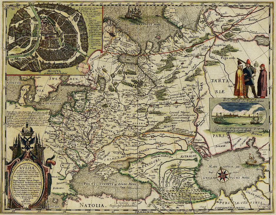
![Russiae, Moscoviae et Nartariae descriptio AuÑtore Antonio Jenkensono Anglo? Edita Londini Anno 1562 et dedicate illustris D.Henrico Sydneo Walliae praesidi. [ London, 1562].](images/01.jpg)
![Russia cum confinijs. Per Gerardum Mercatorem. [Duysburg, 1595].](images/02.jpg)
![Evropa. J.Hondius inuentor. I le Clerc excudit. [Amsterdam], 1602.](images/03.jpg)
![Nova tabula Magni Ducatus Finlanmdiae in Provincias DivisaâḊPer F. de Witt. [Amsterdam, 1680-1690].](images/05.jpg)
![Imperii Russici sive Moscoviae Status Generalis, in ejus Regna Ducatus, Provincias, Populosque Subjacentes DiviusâḊ Per F. de Witt. [Amsterdam,1687-1692].](images/06.jpg)
![Geographical Drawing of Ingermanland with its Towns, Districts and (their Subdivisions -) Pogosty, Churches, Chapels, Homesteads and Villages, and well as with all Lakes, Rivers and Streams, Bakeries and Saw-mills, Mills and Fisheries and Anchorages etc. Engraved by Adriaen Schoonebeck. Ŵoscow, St.-Petersburg: the Moscow State Armoury, the Travelling Engraving Workshop, 1705].](images/07.jpg)
![Map of Russian-Swedish Borders by the Perpetual Peace Terms of 1722 AD. Engraved by Pieter Pickaerdt. [Saint Petersburg: Saint Petersburg printing house, 1724].](images/08.jpg)
![...New and Authentic Map of the Entire Ingermanland Containing Towns and Fortresses, Suburbs, Factories, Estates, Villages, Mills, Rivers, Lakes and Part of the Gulf of Finland and Lake Ladoga as well as the Ladoga and others Canals and Major Roads etc...Ivan Kirilov. Engraved by Alexei Rostovtsev. [Saint Petersburg: Synodal printing house], 1727.](images/09.jpg)
![Lake Ladoga and the Gulf of Finland with the Surrounding Area. Lacus Ladoga et sinus Finnicus cum interiacentibus et adiacentibus Regionibus. J. Grimel del. [The cartouche was engraved by J.E. Grimmel. St.-Petersburg: The Geographical Department of the Academy of Sciences, 1741-1742].](images/10.jpg)
![Map of the Neva Riva from Lake Ladoga to Saint Petersburg. Fluvius Newa e Lacu Ladoga Petropolin versus procurrens. J.Grimel del. [The cartouche was engraved by J.E. Grimmel. St.-Petersburg: The Geographical Department of the Academy of Sciences, before 1742].](images/11.jpg)
![Map of Ingermanland and Karelia Printed at the Imperial Academy of Sciences. [The cartouche was engraved by J.E. Grimmel]. St.-Petersburg: [The Geographical Department of the Academy of Sciences, about 1742].](images/12.jpg)
![Ingermanlandiae seu Ingriae novissima Tabula luci tradita Per Homannianos Heredes Norib. A. MDCCXXXIV. [Nuremberg], 1734.](images/13.jpg)
![Flow of the Neva River from Lake Ladoga to Saint Petersburg. . Fluvius Newa e Lacu Ladoga Petropolin versus procurrens recens delineatus jam vero ad exemplar Petropolitanum aeri incissus a Matthaeus Seutter, Sac. Caes. Maj. Geogr. Aug.Vind. Cum Priv. Sumi. Vicariat. in part. Rheni, Franc. et Suev. jur. [Augsburg, 1740-1750s].](images/14.jpg)
![Ladoga Canal. Canalis Ladogenis nova Delineatio secundum exemplar Petropolitanum aeri incidit Matthaeus Seutter, Sac. Caes. Maj. Georg. Aug.V. Cum Priv.Sumi Vicariat in part Rheni, Franc. et Seuv. juris. [Augsburg, 1740-1750s].](images/15.jpg)
![Lake Ladoga and the Gulf of Finland with the Surrounding Area. Consspectus recens et accuratus magnae partis Lacus Ladogae et Sinus Finnici cum interjacentibus ad exemplar Petropolitanum in aes incidit Matthaeus Seutter, S.C.M.G. Aug.V.Cum Priv.Sumi Vicariat. in part Rhen:Suev:et Franc:Juris. Augsburg, [1740-1750s].](images/16.jpg)
![Nova et accurata delineatio Ingriae et Careliae cum magnna parte Sinus Finnici et hacus Ladogae, mec non Inssularum adjacentium Aeri incidit et excudit Matthaceus Seutter, S. Caes. Maj. Geogr. Aug. Vind. Cum Gratia et Privilegio S.R.Vicariatus in partileg Rheni, Franconici et Sveviae Juris. Matthaeus Seutter. [Augsburg, 1740-1750s].](images/17.jpg)
![Locations of Places between the Town of Arkhangelsk, Saint Petersburg and Vologda. [Saint Petersburg: the Geographical Department of the Academy of Sciences, 1745].](images/18.jpg)
![Map of Saint Petersburg Province Comprising Ingermanland, Part of Novgorod and Vyborg Provinces. Compiled by Ja.F. Schmidt in 1770. Engraved by S.Sklunov. [St. Petersburg: The Geographical Department of the Academy of Sciences], 1770.](images/19.jpg)
![Map of St. Petersburg Province. Compiled by Ŵlexander Vil'brekht. Engraved by Alexei Savinkov. [Engraver of the cartouche is] G. Kharitonov. [Saint Petersburg: the Geographical Department of the Cabinet, the Mining Academy's engineering school, 1792].](images/20.jpg)
![Map of Environs of Saint Petersburg. Compiled by Ŵ.Vil'brekht. Engraved by G.Kharitonov and A.Savinkov. [Saint Petersburg: The Geographic Department of the Cabinet of Her Imperial Majesty, the Mining Academy's engineering school, 1796-1800].](images/21.jpg)
![Topographical Map of St. Petersburg Province. Compiled at the Scale of 1:210,000 on the Basis of Major-General Fedor Schubert' Survey and Engraved at the Military Topographic Depot. Engraved by Several Hands. [Saint Petersburg], 1834.](images/23.jpg)
![Map of the Industry of Saint Petersburg Province 1853. Copiled by N. Overchenko. Saint Petersburg, A.Transchel's Lithographic Press, [1854].](images/25.jpg)
![Geognostic Map Saint Petersburg Province. Compiled in 1866 and 1867 by I. Bok. [S.l., 1867?].](images/26.jpg)
![Map of the Territory now Occupied by Saint Petersburg, Made in 1698. Architect E.V.Schwartz. [Saint Petersburg: Ŵ. Ilyin's Cartographic Establishment, 1872].](images/27.jpg)
![Ethnographical Map of St. Petersburg Province. S.l., [the second half of the 19th cent.?].](images/28.jpg)
![Map of St. Petersburg Province. St. Petersburg, A. Ilyin's Cartographic Establishment, [1897-1906?].](images/29.jpg)
![Naselenie. Vaesto. Population. Leaves 1-2. The Population Density of Leningrad Region. Compiled by the Geographic Economic Research Institution under the editorship of the Leningrad Regional Planning Committee. [Leningrad: the Geographic Economic Research Institution, 1934].](images/32.jpg)
![Promyshlennost'. Teollisuus. Industry. Leaf 2. The Sectoral Structure of the Industry of Leningrad Region in 1932. Compiled by the Geographic Economic Research Institution under the editorship of the Leningrad Regional Planning Committee. [Leningrad: the Geographic Economic Research Institution, 1934].](images/33.jpg)
![Energetika. Energeetiikka. Energetic. Leaf 3. The Electrification of Leningrad Region. Compiled by the Geographic Economic Research Institution under the editorship of the Leningrad Regional Planning Committee. [Leningrad: the Geographic Economic Research Institution, 1934].](images/34.jpg)