War Maps and Pans of the Russian Empire in the 18th Century
Northen War (1700-1721)

Peter the Great understood the importance of map-making for his reforms and invited foreign masters to Russia. By the order of Peter I, the Dutch print-maker Pieter Pickaerdt established a mobile engraving workshop for producing prints and maps during the Great Northern War. In 1703-1704, Pieter Pickaerdt's shop worked in the camps of Peter the Great near the Swedish fortresses of Nöteborg and Nyenskans (Nyenschantz) Shlisselburg, Narva, and an et cetera, to promtly reflect the war operations. Since 1705, the work continued at the Moscow Kremlin Armoury, from 1708 - at a workshop established at the Moscow Printing Yard, and since 1714 - in the first St. Petersburg Printing House.
The engravings depicted plans of sieges and attackes of fortresses, scenes of naval battles, warships, fireworks in honor of significant events and much more. The prints were distributed among the troops, went deep into the country, were sold at printing houses and were sent by Peter I with letters. The additional information on the plans reinforces their historical value. The names of the regiments and their commanders, the indications of the sections of the fortified walls through which the storming groups penetrated in - the numerous details of the plans make it possible to recreate the real course of the battles of the Northern War. Besides individual issues, engravings and maps were combined in the landmark of the Petrine era «The Book of Mars», the famous description of events of the Great Northern War.
In total, more than 30 plans on the battles of the Northern War were engraved. In the Maps Department of the National Library of Russia, some of these publications are kept.
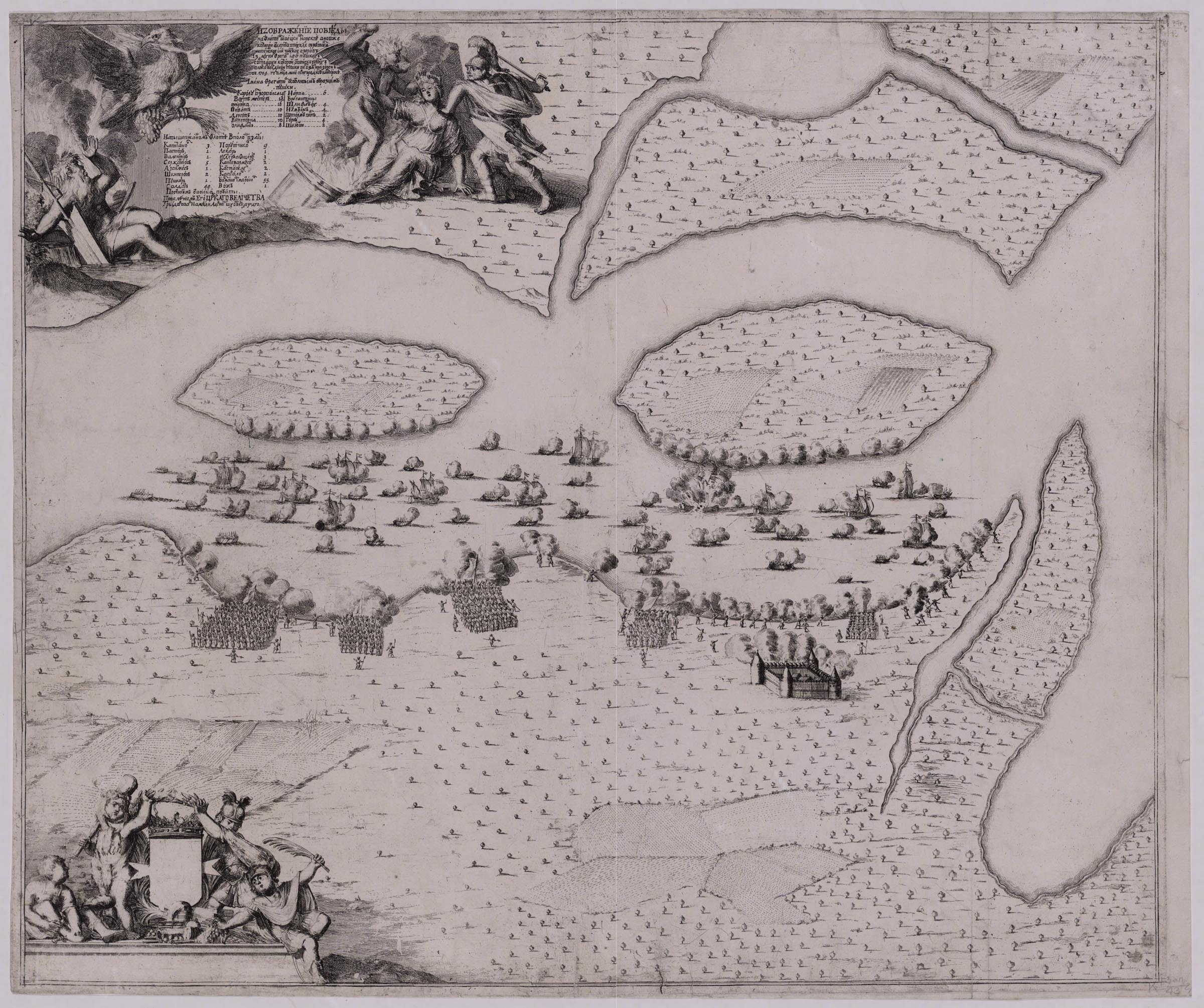
Perspective plan of the mouth of the Emajõgi River which flows into Lake Peipsi from the south-west. It shows the battle between the Swedish fleet and the Russian army in May 1704, when a detachment of Major-General N. von Verdin defeated by the Swedish flotilla and captured 12 ships with guns. The flagship "Carolus" escaped captivity - according to one version, the flotilla commander Admiral Karl Gustaf Löschern von Hertzfelt, blew up the ship and died together with the crew, but in the Peter I's «History of the Northern War» it is stated that the ship exploded 'from grenades, thrown onto it'. The result of the battle was the complete control of Russia of shipping movements on Lake Peipsi. The engraving was produced from a drawing, made at the place of the battle and sent to Adriaan Schoonebeeck for printmaking in the letter of General Admiral Count Feodor Golovin.
Part of the engraving of Shhonebek with a decrease was engraved and, in 1713, was included in the first edition of the Book of Mars under the name "Victory on Lake Peipsi". A reduced copy of a part of Schoonebeeck's print was re-engraved and, in 1713, was included in the first edition of the «Book of Mars» under the name "Victoria on Lake Chutsky".
K 1-Zap 2/43
Electronic resource
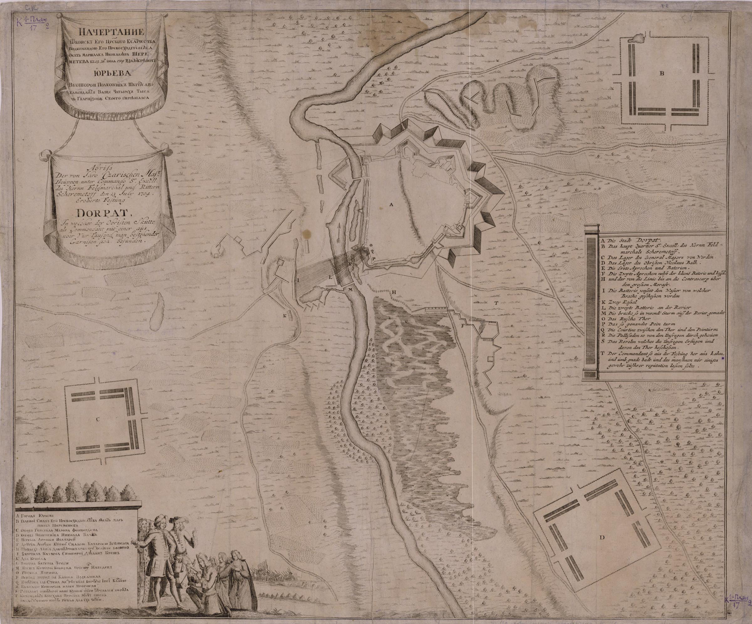
The plan depicts the siege of the City of Dorpat. To strengthen the Russian positions in the Baltic region after defeating the Swedish fleet on Lake Peipsi at the mouth of the Emajõgi, it was necessary to take the city of Dorpat (the former Yuryev, modern Tartu). The siege began on 9 June 9 1704. The city surrendered on 13 July.
The plan was compiled and drawn at Pieter Pickaerdt's mobile engraving workshop. The engraving from it was produced in Adriaan Schoonebeeck's workshop at the Moscow Kremlin Armoury. Later, the plate was printed in Amsterdam after an engraving by Jacob Keyser - an exact copy of the work of Schoonebeeck. In the 40-s of the 18th century, the plan was reprinted in St. Petersburg from the engraving by Jacob Keyser.
A reduced and amended copy of Schoonebeeck's print was re-engraved by A. Rostovtsev for the first edition of the «Book of Mars» in 1713.
K 1-Plan 2/17
Electronic resource
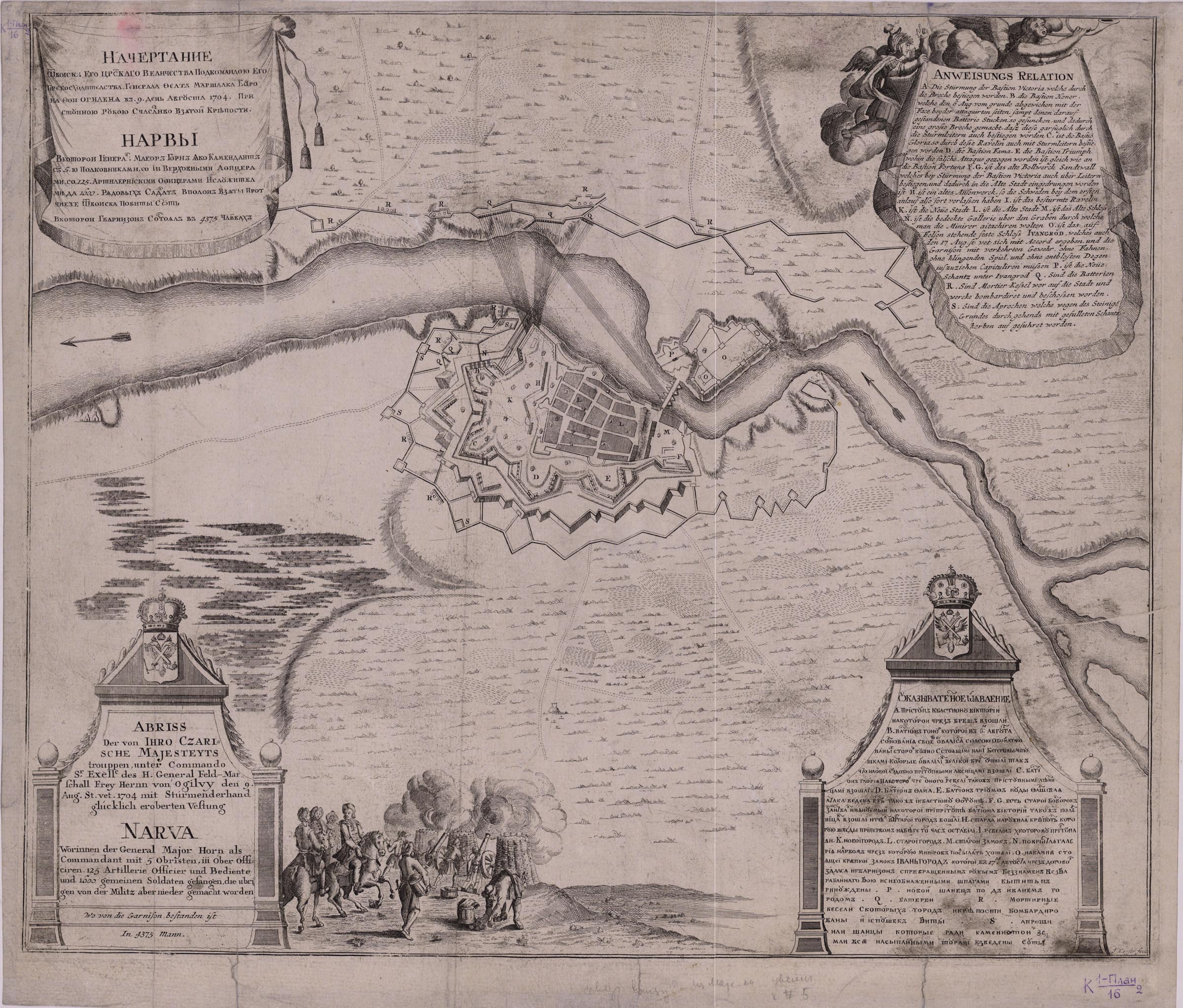
The plan depicts capturing the Fortress of Narva by the Russian troops. The assault began on 30 June 30 1704, the city surrendered on 9 July. The engraving was made in the workshop of Adriaan Schoonebeeck at the Kremlin Armoury, the plan was compiled and drawn in the mobile engraving workshop. Later, it was printed in Amsterdam from an engraving produced by Jacob Keyser - an exact copy of the work of Schoonebeeck. In the 40s of the 18th century, the plan was reprinted after Jacob Keyser's engraving in St. Petersburg.
K 1-Plan 2/16
Electronic resource
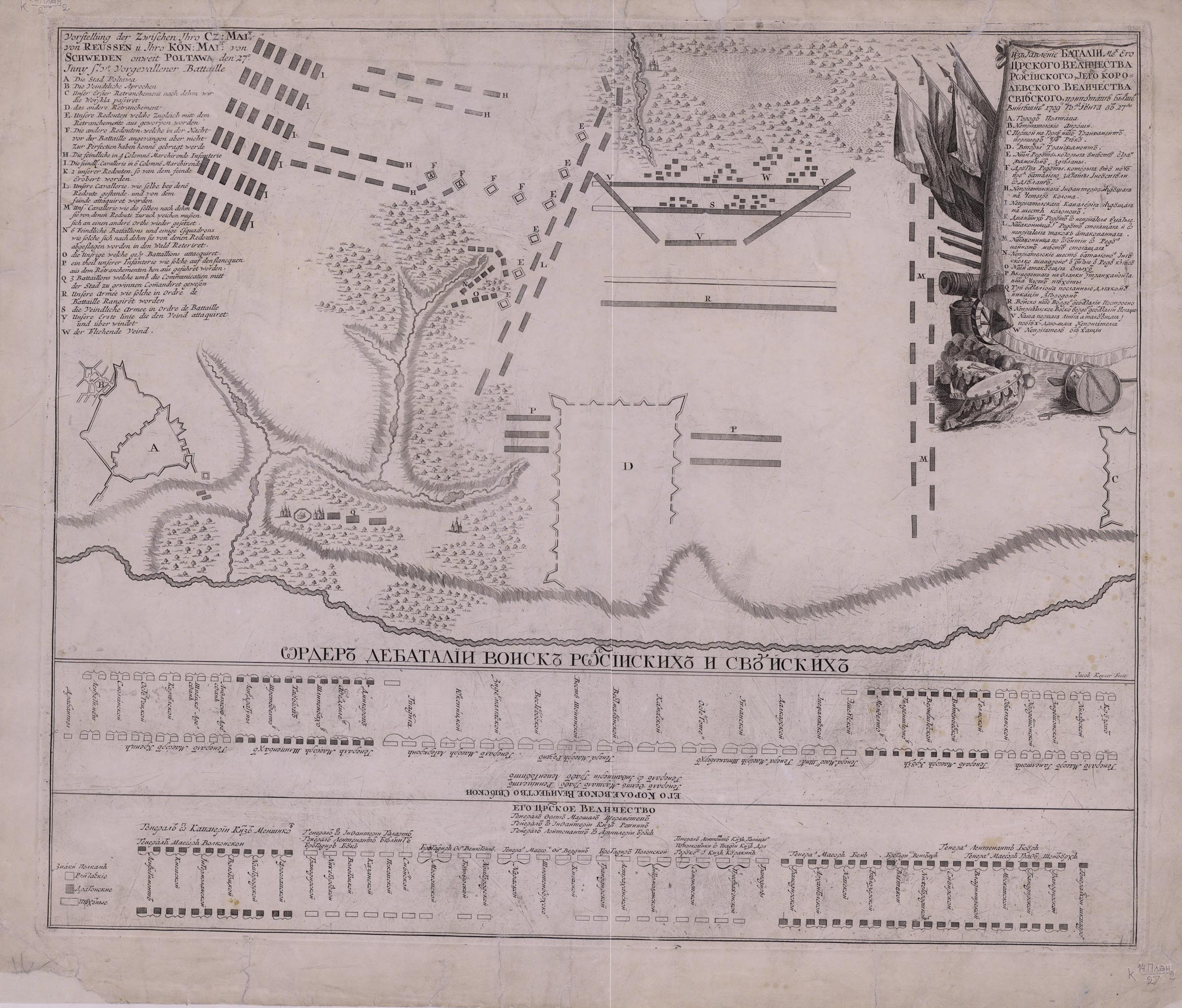
On 2 August 1709, Peter I sent "a drawing of the victory at Poltava" to I. Musin-Pushkin with an order "to cut out a board and to print five or six tens of copies from it …". It was this drawing that served as the basis for the engraving of P. Pickaerdt. The Maps Department held a copy engraved by Jacob Keyser, a later reprinting, with slight changes, of Pickaerdt's work.
Engraving of P. Pickaerdt under the title "The Battle of Poltava" in a reduced form was included in the Book of Mars of 1713.
Electronic resource
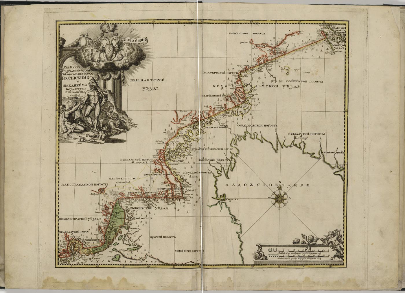
The map shows Russian-Swedish borders established by the Peace Treaty of Nystad which ended the Great Northern War in 1721.
A decorative cartouche has an allegorical picture of Hercules, releasing Theseus from the Underworld, as a symbol of the liberation of the primordial Russian territories from Swedes; at the top is the coat of arms of the Russian Empire.
Electronic resource