18th Century Plans
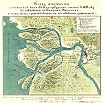 Russian, Finnish and Swedish settlements were located on the banks of the Neva River and along the coasts of the Gulf of Finland long before the founding of the city of St. Petersburg. In the 13th century, Russia possessed this land, but, after the Treaty of Stolbovo of 1617 which ended the Ingrian War between Sweden and Russia, the area was ceded to Sweden by Russia and renamed Ingria until the Great Northern War.
«Plan of the Territory now Occupied by Saint Petersburg…» shows the territory of the delta of the Neva River, the mouth of the Ohta River and the Swedish Nyenschantz fortress built in 1611 by the Swedish King Charles IX.
The plan was compiled and published in 1872, using the cartographic material made in 1698 the commandant of the Nyenschantz fortress, Swedish baron Avraam Cronjort. The area of the Neva delta is shown as a rather deserted site (contrary to facts), the main objects depicted on it are the fortress walls and adjacent buildings. The capture of the fortress by Russian troops during the Northern War was a decisive event in the history of the new Russian capital. Subsequently the Nyenschantz fortifications were razed to the ground, on their place there was located the Tar Works. In 2000, a memorial monument was erected on the site of the fortress.
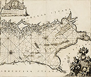
Especially valuable is the «Map of the Eastern Part of the Gulf of Finland» of 1703 — the first Russian printed map to show Saint Petersburg. It is also one of the first Russian nautical charts to be engraved by Pieter Pickaerdt at the mobile workshop established by the order of Peter I to promptly reflect operations of the Great Northern War.
 The maps of the 18th century contained art cartouches that carried an important meaning. For instance, a cartouche, depicting Neptune and the gods of four Russian seas, symbolizes the adding the Baltic Sea to the three seas that Russia already had. The god of the Baltic Sea, holding a harpoon and the key in his hand, represents the capture of the Swedish fortress of Nöteborg that later gave the name of Shlisselburg, meaning "Key-fortress" in German, which refers to Peter the Great's perception of the fortress as the "key to Ingria". The god of the Azov Sea with the inverted crescent on the harpoon indicates victory over Turkey. The god of the White Sea holding a fish-spear is a symbol of sea fishing; the god of the Caspian Sea is accompanied by an allegorical representation of the Volga River.
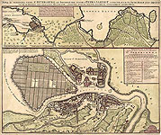 Peter the Great's active foreign policy, the large-scale transformation of the country attracted the attention of Europeans to Russia and its new capital. This resulted in the creation of a number of St. Petersburg plans by foreign authors.
The Map «Nova ac verissima urbis St. Petersburg...», issued by the Amsterdam cartographer and publisher Reiner Ottens, consists of two parts. Its upper portion is the map of the river Neva, that covers the territory of St. Petersburg Province from the Gulf of Finland to the Volkhov River. It was the first map to depict the Ladoga Canal which construction was completed in 1731. Along the coast of the Gulf of Finland are shown palaces and parks of Strelna, Peterhof and Oranienbaum.
At the bottom of the sheet there is depicted the central part of St. Petersburg.
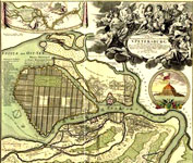 One of the most spectacular foreign plans is the «Topographical Description of New Russian Capital City…», issused by the engraver and mapmaker Johann Baptist Homann in Nuremberg during West European tours made by Peter I in 1716 and 1717. The plan reflects both the actual layout of the new capital (by the beginning of 1718), and the planned construction projects. In particular, it shows the rectangular grid of canals across Vasilievsky Island, designed by the Italian architect Domenico Trezzini. The project has never been implemented, however, the system of canals formed the basis for the modern 'lines' - parallel streets that run across the island.
The decorative cartouches adorning the plan, contain a portrait of Peter I, surrounded by allegorical figures, and a view of Kronschlot Fort - the first fortification of the town of Kronstadt. Top left there is the map of the Neva River from Lake Ladoga to the Gulf of Finland, with a decorative allegorical figure of St. Peter the Apostle, the holy patron of the city. These plans were based on visual and semi-instrumental measurements.
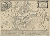 The next necessary step in mapping the city was conducting accurate surveys. The first instrumental surveys began to be conducted in the city of St. Petersburg by the Academy of Sciences from 1729. This made it possible to accurately mirror its actual layout and create the first fixation key plan, which was the «Plan of the Imperial Capital City of St. Petersburg, Composed in 1737». Future city's main thoroughfares are clearly visible on the map: Large Nevsky Prospect (Nevsky Prospect), Middle Prospect (Gorokhovaya Street), Liteiny Street (Liteiny Prospect), Garden Street (from Nevsky Prospect almost to Gorokhovaya Street).
The plan was produced at the Engravery of the Academy of Sciences. It was published in 1741 in the album: «Houses, Libraries and Curiousity Chambers of the Imperial Academy of Sciences in Petersburg».
This is the first Russian printed map of the city available today. The plan was based on the topographical surveys made by Academy of Sciences in Petersburg since 1729.
The plan objectively reflect the current layout of the city in detail and served as a basis for the work of the «Saint-Petersburg Construction Commission» established for purposes of the reconstruction of the capital, especially necessary after the fires in 1736 and 1737.
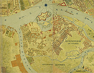 The task of compiling a general plan to guide the growth and land development of the whole city was assigned to Engineer Major Johann Siegheim, who conducted topographical survey of the city between 1737 and 1740. In 1738, Siegheim compiled a plan on the scale of 60 sazhens (measure of length = 2.34 metres) to inch, which has never been published. In the second half of the 19th century, P. Petrov produced a decreased reproduction of the plan.
The plan is the most comprehensive of its time and has a great historical significance.
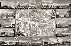 One of the most beautifully executed and impressive by its size was the «Plan of the Capital City of St. Petersburg with the Depiction of its Most Distinctive Views». It was published in 1753 to celebrate the first anniversary of the city. The plan of St. Petersburg was created to mark this event, and "for the glory and honor of the Russian Empire". It has become a recognized masterpiece of Russian engraving art. The plan was drawn in the Geographical Department of the Academy of Sciences under the direction of the junior scientific assistant I. F. Truskott. This plan gives an accurate account of Saint Petersburg's streets. It also shows upcoming buidling projects and some of the best-known places lost forever. The plan contains the prospective views of St. Petersburg’s best buildings.
The plan of 1753 reflects the significant changes that had taken place since 1737: between the Nevsky and Voznesensky Avenues, there was built the third central Saint Petersburg's major thoroughfare - "Middle Avenue" (now Gorokhovaya Street). Since then, the center of Saint Petersburg developed along three radial axes meeting at the Admiralty's spire: Nevsky Prospekt, Middle Prospekt and Voznesensky Prospekt. Thus, there was formed the structure of the city center, that still exists. That plan of 1753 forever cemented a strict and efficient street layout of the northern capital.
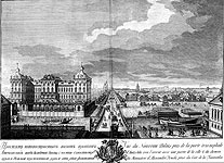
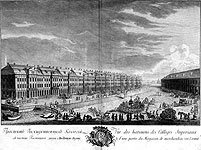 The plan is accompanied by twelve views of the city that show the historical appearance of St. Petersburg in the mid-18th century, and have independent artistic value. The illustrations were designed mainly by the graphic artist М.I. Makhaev, so that his name was extended to the whole plan which gained the common term of the «Makhaev's Map».
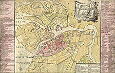 The «New Plan of the Capital City and Fortress of St. Petersburg» (1776) was compiled by the «Commission for the Stone Cnstruction in St. Petersburg and Moscow», established in 1762. Its task was to study the existing city planning and develop a new plan with the replacement of wooden structures by stone buildings.
Project plans were made up under the direction of the chief architect of the Commission Alexei Kvasov. The plan is a reduced engraved copy of the general project plans. It was compiled using materials of large-scale surveys of St. Petersburg during the period of 1765-1773. The plan served as a basis for almost all printed plans of the last quarter of the 18th century.
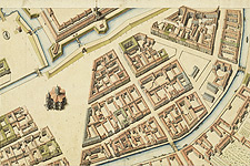 Then, during the period from 1764 to 1773, work was undertaken to create long-term plan of St. Petersburg. The plan was named the ««Plan of P. de Saint-Hilaire, A. Gorikhvostov, I. Sokolov» after the officials who made a topographical survey of the city. Students of the Academy of Arts were involved in the creation of the plan. Before being put on the plan, every building was measured and drawn in detail. The final total area of all sheets should have reached 590 m², but the plan was not completed. By now, 112 safe sheets and a number of fragments have survived and been described. The handwritten original plan is stored in the Russian State Archive of the Navy. The exhibited sheets with the images of the Peter and Paul Fortress and St. Isaac's Square are made after the completion of the survey and may represent a resumption of work on the compilation of long-term city plan.
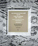 In 2003, the publishing house "Kriga" and the Russian State Archive of the Navy issued a facsimile edition of «Perspective Plan of St. Petersburg in 1765-1773», consisting of two books: the first book consists of sheets of the plan with a description as well as a map of the central city districts - Vasilievsky and Admiralty parts; the second contains the text of the scientific description. The plan is a unique source for the study of development of Vasilyevsky Island and Admiralty part, it presents picture of the two districts of St. Petersburg during the period of 1765-1773.